| dbo:abstract
|
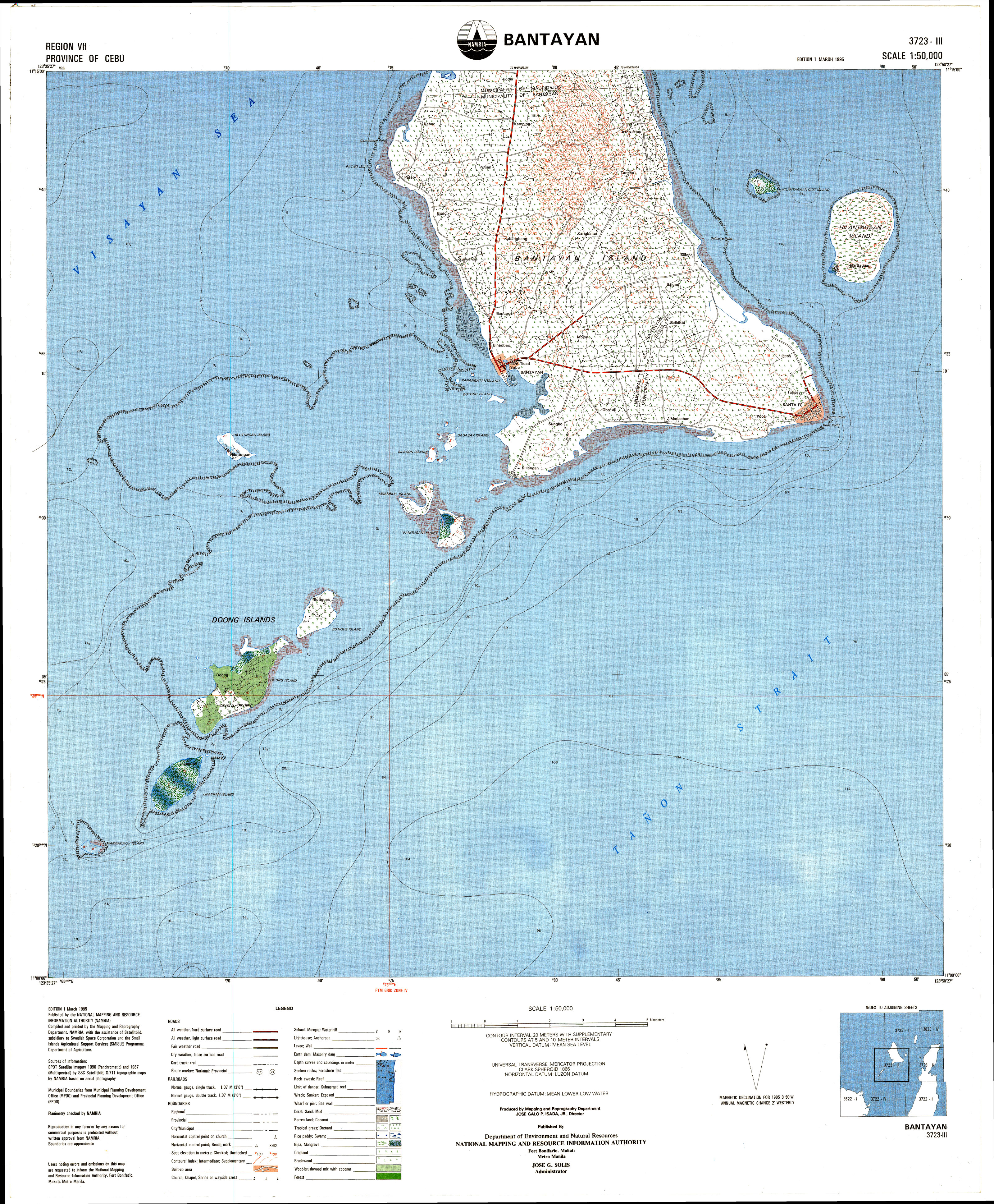
- Bantayan Island is an island located in the Visayan Sea, Philippines. It is situated to the west of the northern end of Cebu island, across the Tañon Strait. According to the 2015 census, it has a population of 145,436. String_Module_Error:_String_subset_index_out_of_range_1-1" class="reference"> The island is administratively divided into three municipalities:
* Bantayan (the largest municipality, covering the central part)
* Madridejos (covering the northern portion)
* Santa Fe (center of tourism in Bantayan Island, covering the southeastern portion) The island area is 108.77 square kilometers (42.00 sq mi). The island is mostly covered with coconut palms; the elevation is mostly below 10 meters (30 ft), with only one taller hill, at 26 meters (90 ft), in barangay Atop-atop. (en)
- Bantayan ist eine philippinische Insel in der Visayas-See. (de)
- L'Île Bantayan est une île située dans la mer de Visayan, dans les Philippines. Elle est située à l'ouest de l'extrémité nord de Cebu, à travers le détroit de Tañon. Selon le recensement de 2010, la population est de 139 960 habitants. L'île est divisée administrativement en trois municipalités :
* Bantayan (la plus grande municipalité, couvrant la partie centrale) ;
* Madridejos (couvrant la portion nord) ;
* Santa Fe (couvrant la portion est).
* Portail des Philippines
* Portail du monde insulaire (fr)
- Isla de Bantayan es una isla en las Filipinas situada en la parte oeste de la punta norte de la isla de Cebú. Es políticamente una parte de la provincia de Cebú. La isla es accesible desde la ciudad de Cebú (a través de la Terminal de Autobuses del Norte) y luego a través de un ferry.
* La isla se compone de tres municipios:
* Bantayan, Cebú
* Madridejos, Cebú
* Santa Fé, Cebú (es)
- バンタヤン島(英語: Bantayan Island)はフィリピン、ヴィサヤ海に位置する島。タノン海峡を挟んでセブ島の北端の西に位置している。2010年の国勢調査では住民が136,960人であった。 島はセブ州に属しており、島内中部で最大の都市、北部の、東部のの3自治体に分かれている。 (ja)
- Bantayan is een eiland in de Filipijnen. Het ligt ten noorden van het eiland Cebu en behoort tot de provincie Cebu. Volgens de officiële telling uit 2000 had het eiland ongeveer 120.000 bewoners. (nl)
- Bantayan är en liten ö i Filippinerna som ligger norr om Cebu. Bantayan är en tropisk ö med många aktiviteter. År 2000 hade ön 120 101 invånare.Antalet turister som besöker Bantayan har ökat under senare år. (sv)
- 班塔延島(宿霧語:pulo sa Bantayan;他加祿語:Pulo ng Bantayan;英語:Bantayan Island)是菲律宾的一个島嶼,位於宿霧島西北面的米沙鄢海,由宿霧省負責管轄,長16公里、寬11公里,面積116.4平方公里,前往該島的旅客人數近年不斷增加,2015年人口120,447。 (zh)
|
| rdfs:comment
|
- Bantayan ist eine philippinische Insel in der Visayas-See. (de)
- L'Île Bantayan est une île située dans la mer de Visayan, dans les Philippines. Elle est située à l'ouest de l'extrémité nord de Cebu, à travers le détroit de Tañon. Selon le recensement de 2010, la population est de 139 960 habitants. L'île est divisée administrativement en trois municipalités :
* Bantayan (la plus grande municipalité, couvrant la partie centrale) ;
* Madridejos (couvrant la portion nord) ;
* Santa Fe (couvrant la portion est).
* Portail des Philippines
* Portail du monde insulaire (fr)
- Isla de Bantayan es una isla en las Filipinas situada en la parte oeste de la punta norte de la isla de Cebú. Es políticamente una parte de la provincia de Cebú. La isla es accesible desde la ciudad de Cebú (a través de la Terminal de Autobuses del Norte) y luego a través de un ferry.
* La isla se compone de tres municipios:
* Bantayan, Cebú
* Madridejos, Cebú
* Santa Fé, Cebú (es)
- バンタヤン島(英語: Bantayan Island)はフィリピン、ヴィサヤ海に位置する島。タノン海峡を挟んでセブ島の北端の西に位置している。2010年の国勢調査では住民が136,960人であった。 島はセブ州に属しており、島内中部で最大の都市、北部の、東部のの3自治体に分かれている。 (ja)
- Bantayan is een eiland in de Filipijnen. Het ligt ten noorden van het eiland Cebu en behoort tot de provincie Cebu. Volgens de officiële telling uit 2000 had het eiland ongeveer 120.000 bewoners. (nl)
- Bantayan är en liten ö i Filippinerna som ligger norr om Cebu. Bantayan är en tropisk ö med många aktiviteter. År 2000 hade ön 120 101 invånare.Antalet turister som besöker Bantayan har ökat under senare år. (sv)
- 班塔延島(宿霧語:pulo sa Bantayan;他加祿語:Pulo ng Bantayan;英語:Bantayan Island)是菲律宾的一个島嶼,位於宿霧島西北面的米沙鄢海,由宿霧省負責管轄,長16公里、寬11公里,面積116.4平方公里,前往該島的旅客人數近年不斷增加,2015年人口120,447。 (zh)
- Bantayan Island is an island located in the Visayan Sea, Philippines. It is situated to the west of the northern end of Cebu island, across the Tañon Strait. According to the 2015 census, it has a population of 145,436. String_Module_Error:_String_subset_index_out_of_range_1-1" class="reference"> The island is administratively divided into three municipalities:
* Bantayan (the largest municipality, covering the central part)
* Madridejos (covering the northern portion)
* Santa Fe (center of tourism in Bantayan Island, covering the southeastern portion) (en)
|


.JPG)
.svg)
.jpg)