| dbo:abstract
|
- نور عبارة عن مياه ضحلة أو ضفة رملية عند مصب نهر التايمز في إنجلترا. ويمثل النقطة التي يلتقي فيها نهر التايمز مع بحر الشمال، في منتصف الطريق تقريبًا بين هافينغور كريك في إسيكس وواردين بوينت في جزيرة شيب في كنت. حتى عام 1964، كان يمثل الحد البحري لسلطة ميناء لندن. نظرًا لأن الضفة الرملية كانت تشكل خطراً كبيراً على الشحن القادم من وإلى لندن، في عام 1732 حصل على أول سفينة إضاءة في العالم. أصبح هذا معلما رئيسيا، وكان يستخدم كنقطة تجميع للشحن. اليوم يتم تمييزها بواسطة عوامة بحر رقم 1. أَطلق اسم نور على مرسى أو على طريق مفتوح، يستخدمه أسطول بحر الشمال الملكي، وقيادة RN المتمركزة هناك. كان موقع تمرد شهير في 1797. (ar)
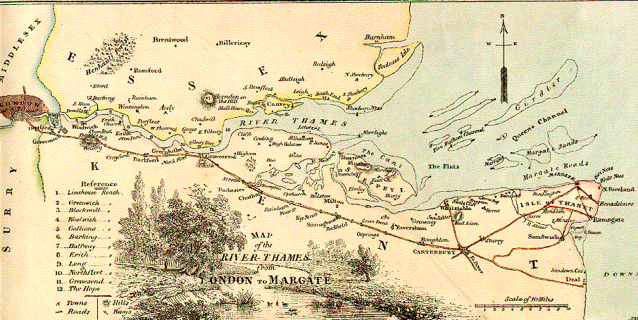
- The Nore is a long bank of sand and silt running along the south-centre of the final narrowing of the Thames Estuary, England. Its south-west is the very narrow Nore Sand. Just short of the Nore's easternmost point where it fades into the channels it has a notable point once marked by a lightship on the line where the estuary of the Thames nominally becomes the North Sea. A lit buoy today stands on this often map-marked divisor: between Havengore Creek in east Essex and Warden Point on the Isle of Sheppey in Kent. Until 1964 it marked the seaward limit of the Port of London Authority. As the sandbank was a major hazard for shipping coming in and out of London, in 1732 it received the world's first lightship. This became a major landmark, and was used as an assembly point for shipping. Today it is marked by Sea Reach No. 1 Buoy. The Nore is an anchorage, or open roadstead, used by the Royal Navy's North Sea Fleet, and to its local Command. It was the site of a notorious mutiny in 1797. The Great Nore is the cul-de-sac deep channel to the south of the Nore which opens out to the locally most deep water to the east, the Sheerness Approach. (en)
- Le Nore est un banc de sable dans l'estuaire de la Tamise en Angleterre, près de la ville de Sheerness sur l'île de Sheppey. Il marque le point où la Tamise rejoint la mer du Nord. (fr)
- 노어(Nore)는 잉글랜드의 템스 강에 위치한 사주로, 템스 강과 북해가 만나는 지점이다. (ko)
- ノア(英: Nore)は、イギリス、イングランドのテムズ川の三角江にある砂州。シェピー島にあるの町に近い。テムズ川と北海が出会う地点である。 ノアは海運の難所であり、1732年、世界初の灯台船が置かれた。灯台船はが特許をとった発案であり、ノアの灯台船はその実験として置かれたものである。1819年にはイングランドに9隻の灯台船があったことから、その実験は成功したということが知れる。ノアの灯台船は、トリニティ・ハウス(全国灯台協会、General Lighthouse Authority)によって運営されていた。 初期のノア灯台船は、小型の木造船で、しばしばオランダ製のギャリオット船が用いられた。19世紀末には回転式の灯火を装備した大型の船も使用されたが、1915年頃に当局によって灯台船の使用は廃止された。エセックス州の(Shoeburyness)とケント州のシェピー島の中間にあるシー・リーチ1番(Sea Reach No.1)ブイが、以前の灯台船の停泊地点を示している(2006年現在)。これはテムズ川の終わりと北海の始まりを定めている。 1899年から1955年まで、イギリス海軍は「ノア管区司令長官」の役職を置き、ロンドン港への入り口の防衛と大ブリテン島東海岸沿いの海運の保護の責任者としていた。 (ja)
- Il Nore è un banco di sabbia alla foce del Tamigi, in Inghilterra. Marca il punto in cui il Tamigi incontra il Mare del Nord, circa a metà tra , nell'Essex, e , sull'isola di Sheppey, nel Kent. Fino al 1964 segnalava il limite dell'. Siccome il banco di sabbia rappresenta un pericolo per la navigazione in entrata ed uscita da Londra, nel 1732 vi fu installata la prima nave faro al mondo. La nave faro divenne un importante punto cospicuo, utilizzato come punto di ritrovo dalle navi nell'area. Oggi la secca è segnalata dalla boa Sea Search 1. Il Nore dà il suo nome all'ancoraggio utilizzato dalla flotta del Mare del Nord della Royal Navy e alla base di comando della RN lì vicine. Fu il luogo di un famoso ammutinamento nel 1797. (it)
- Nore är en sandbank i floden Themsens mynning i England. Det ligger 5 km nordost om staden Sheerness, grevskapet Kent och 7 km sydost om Southend-on-Sea.Vid Nore utlades 1732 världens första fyrskepp. (sv)
- Нор — якорная стоянка в устье Темзы, Англия. Названа по одноименной песчаной банке. Расположена в месте впадения реки Темзы в Северное море, примерно на полпути между Хавенгор-крик в Эссексе и Уорден-пойнт в графстве Кент. (ru)
|
| rdfs:comment
|
- Le Nore est un banc de sable dans l'estuaire de la Tamise en Angleterre, près de la ville de Sheerness sur l'île de Sheppey. Il marque le point où la Tamise rejoint la mer du Nord. (fr)
- 노어(Nore)는 잉글랜드의 템스 강에 위치한 사주로, 템스 강과 북해가 만나는 지점이다. (ko)
- ノア(英: Nore)は、イギリス、イングランドのテムズ川の三角江にある砂州。シェピー島にあるの町に近い。テムズ川と北海が出会う地点である。 ノアは海運の難所であり、1732年、世界初の灯台船が置かれた。灯台船はが特許をとった発案であり、ノアの灯台船はその実験として置かれたものである。1819年にはイングランドに9隻の灯台船があったことから、その実験は成功したということが知れる。ノアの灯台船は、トリニティ・ハウス(全国灯台協会、General Lighthouse Authority)によって運営されていた。 初期のノア灯台船は、小型の木造船で、しばしばオランダ製のギャリオット船が用いられた。19世紀末には回転式の灯火を装備した大型の船も使用されたが、1915年頃に当局によって灯台船の使用は廃止された。エセックス州の(Shoeburyness)とケント州のシェピー島の中間にあるシー・リーチ1番(Sea Reach No.1)ブイが、以前の灯台船の停泊地点を示している(2006年現在)。これはテムズ川の終わりと北海の始まりを定めている。 1899年から1955年まで、イギリス海軍は「ノア管区司令長官」の役職を置き、ロンドン港への入り口の防衛と大ブリテン島東海岸沿いの海運の保護の責任者としていた。 (ja)
- Nore är en sandbank i floden Themsens mynning i England. Det ligger 5 km nordost om staden Sheerness, grevskapet Kent och 7 km sydost om Southend-on-Sea.Vid Nore utlades 1732 världens första fyrskepp. (sv)
- Нор — якорная стоянка в устье Темзы, Англия. Названа по одноименной песчаной банке. Расположена в месте впадения реки Темзы в Северное море, примерно на полпути между Хавенгор-крик в Эссексе и Уорден-пойнт в графстве Кент. (ru)
- نور عبارة عن مياه ضحلة أو ضفة رملية عند مصب نهر التايمز في إنجلترا. ويمثل النقطة التي يلتقي فيها نهر التايمز مع بحر الشمال، في منتصف الطريق تقريبًا بين هافينغور كريك في إسيكس وواردين بوينت في جزيرة شيب في كنت. حتى عام 1964، كان يمثل الحد البحري لسلطة ميناء لندن. نظرًا لأن الضفة الرملية كانت تشكل خطراً كبيراً على الشحن القادم من وإلى لندن، في عام 1732 حصل على أول سفينة إضاءة في العالم. أصبح هذا معلما رئيسيا، وكان يستخدم كنقطة تجميع للشحن. اليوم يتم تمييزها بواسطة عوامة بحر رقم 1. (ar)
- The Nore is a long bank of sand and silt running along the south-centre of the final narrowing of the Thames Estuary, England. Its south-west is the very narrow Nore Sand. Just short of the Nore's easternmost point where it fades into the channels it has a notable point once marked by a lightship on the line where the estuary of the Thames nominally becomes the North Sea. A lit buoy today stands on this often map-marked divisor: between Havengore Creek in east Essex and Warden Point on the Isle of Sheppey in Kent. (en)
- Il Nore è un banco di sabbia alla foce del Tamigi, in Inghilterra. Marca il punto in cui il Tamigi incontra il Mare del Nord, circa a metà tra , nell'Essex, e , sull'isola di Sheppey, nel Kent. Fino al 1964 segnalava il limite dell'. Siccome il banco di sabbia rappresenta un pericolo per la navigazione in entrata ed uscita da Londra, nel 1732 vi fu installata la prima nave faro al mondo. La nave faro divenne un importante punto cospicuo, utilizzato come punto di ritrovo dalle navi nell'area. Oggi la secca è segnalata dalla boa Sea Search 1. Fu il luogo di un famoso ammutinamento nel 1797. (it)
|


