| dbp:caption
|
- 0001-01-27 (xsd:gMonthDay)
- 0001-03-21 (xsd:gMonthDay)
- 0001-04-11 (xsd:gMonthDay)
- 0001-04-24 (xsd:gMonthDay)
- 0001-09-12 (xsd:gMonthDay)
- 0001-09-28 (xsd:gMonthDay)
- (en)
- This image, taken by the microscopic imager, reveals shiny, spherical objects embedded within the trench wall (en)
- Closeup - Rock contains sulfur, magnesium and manganese. (en)
- Annotated version of MER-B traverse to Spirit Mound from Marathon Valley in late 2016 (en)
- A infographic showing the traverse from Victoria to Endeavour, Sol 2592 (en)
- HiRise image from MRO, was laid over 3-D topographic map of the terrain, with 5-fold vertical exaggeration; view looking west on to Perseverance Valley on the western rim of Endeavour crater (en)
- Opportunitys traverse up to February 2015 as it approached Spirit of Saint Louis Crater and Marathon Valley, and came close to traveling the distance of a traditional marathon (en)
- Looking south along Western rim of Endeavour crater, August 2011 (en)
- Traverse as of December 2014 from roughly sol 3750 to 3868 (en)
- Rover's arrival and subsequent path around Cape York, and its departure as it headed south into Botany Bay towards Solander Point between 2012 and 2013 (en)
- Map of the region around Opportunity shows the relative locations of several craters and the rover in May 2010. (en)
- Opportunity arrives at Endeavour crater, Sol 2710 (en)
- Opportunity images a Martian whirlwind (en)
- Opportunitys landing site (en)
- Overall location of Opportunity on the planet Mars (en)
- Landing ellipse of Opportunity; with Bopulu on the left, and the Endeavour, Iazu, unnamed on the right, below the ellipse (en)
- Spheres at Kirkwood, each are about 3 mm across (en)
- The view of Burns Cliff inside Endurance Crater. (en)
- In May 2015 the rover visited Spirit of St. Louis Crater, a shallow crater about long and across. In its center is Lindbergh Mound, about 2-3 meters high. This version of the panorma is annotated and in false color (en)
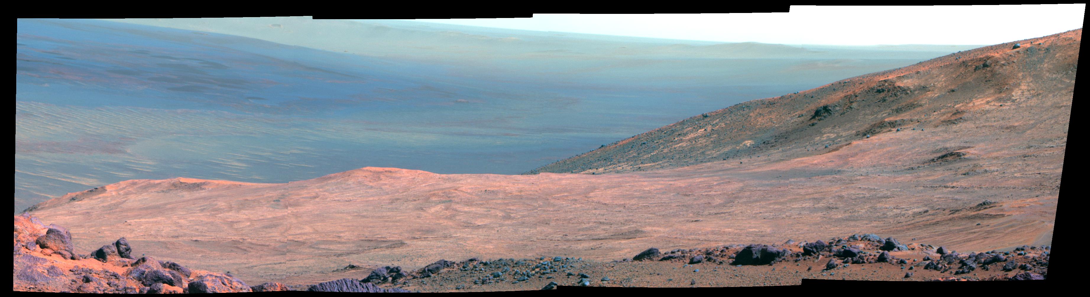
- Marathon Valley as viewed by the Opportunity rover . (en)
- Opportunity's first 360-degree grayscale panorama, taken by the navcam on Sol 1 of the mission, showing interior of Eagle crater at Meridiani Planum (en)
- Greeley Haven panorama – a view of Cape York and the Endeavour crater – was taken while overwintering at the Greeley Haven position at Cape York in the first half of 2012. This false-color panoramic view was combined from 817 individual images taken in the near-infrared, green and violet spectral bands. (en)
- Self-portrait of Opportunity near Endeavour Crater . Note the change in appearance in relation to the photo nine years earlier . (en)
- Opportunitys first self-portrait including the camera mast on Mars (en)
- The view from the rover's perspective from the location noted in the above top-down view. The white lines in the above view indicate the rover's field of view in this image. (en)
- Self-portrait of Opportunity taken early in the mission (en)
- "Mysterious" appearance of a rock shaped as a "jelly doughnut" - sol 3528 & 3540 . (en)
- First color panorama taken by Opportunity, showing the Martian landscape at Meridiani Planum (en)
- Color sat-view of MER-B's track along the Western edge of the crater up to December 2015 (en)
- Annotated elevation map of Opportunity landing site and some surrounding craters including Endeavour and Miyamato (en)
- After rover left Concepcion crater, it took this view southward spotting the rim of Bopulu crater away. (en)
- Traverse map showing location of Greely and the rover's track in 2012 (en)
- Location where "Pinnacle Island" rock was dislodged by rover; mystery solved . (en)
- Mapping out of various aspects of Opportunitys mission up to April 2004 as seen from orbit (en)
- Traverse as of June 2014 from roughly sol 3500 to 3689 (en)
- Traverse as of August 2014 from roughly sol 3728 to 3757 (en)
- Opportunitys path at Solander Point and along Murray Ridge up to February 2014 (en)
|


.jpg)
.jpg)