| dbo:abstract
|
- بتّير هي بلدة ريفية فلسطينية من قرى الريف الغربي لمحافظة بيت لحم، تمتاز بطبيعتها وبساتين الخضار التقليدية، كما أنها تشتهر . (ar)
- Battir —en àrab بتير, Battīr— és un municipi palestí en la governació de Betlem al centre de Cisjordània, situat 6,4 kilòmetres a l'oest de Betlem. Segons l'Oficina Central d'Estadístiques de Palestina (PCBS), tenia una població de 4.993 habitants en 2016. Es troba a uns 760 m sobre el nivell del mar. , de la que en pren el nom Battir, era un poble i fortalesa jueva del segle ii, el lloc de la batalla final de la revolta de Bar Kokhba. Va ser habitada durant els períodes islàmic i romà d'Orient, i en els censos del Mandat otomà i britànic la seva població es va registrar com a musulmana principalment. Battir està situada en el recorregut del , que va servir com la línia d'armistici entre Israel i Jordània des de 1949 fins a la Guerra dels Sis Dies, quan va ser capturada per Israel. En temps anteriors, la ciutat estava al llarg del recorregut de Jerusalem a Bayt Jibrin. El 2007 estava sota el control de l'Autoritat Nacional Palestina. (ca)
- Batir (arabsky بتير) je arabská vesnice v Judských horách, 7 km jihozápadně od Jeruzaléma. Vesnice je součástí Palestinské autonomie (tzv. území B, pod částečnou izraelskou kontrolou). Jméno vesnice zachovává pojmenování starověkého pevnostního města Bejtar (hebrejsky ביתר, také přepisováno Betar), jež jako poslední vzdorovalo Římanům za povstání Bar Kochby. Jeho zbytky jsou identifikovány v Chirbet al-Jahúd uvnitř současné obce. Vesnice a okolní kulturní krajina jsou od června 2014 chráněny jako památka UNESCO. (cs)
- Battir (arabisch بتير, DMG Battīr) oder Betar (hebräisch בֵּיתַּר) ist eine südwestlich von Jerusalem gelegene Siedlung, die seit 2014 zum UNESCO-Weltkulturerbe gehört. In der Ortschaft leben circa 4500 Menschen. Es liegt nordöstlich von „Khirbet el-Yahud“ (dt. Ruine der Juden), einer archäologischen Stätte, die die Ruinen des antiken Betar (hebräisch בֵּיתַּר) umfasst. Der arabische Name Battir bewahrt den hebräischen Namen dieser altorientalischen Siedlung. In unmittelbarer Nähe befindet sich die israelische Kommune Betar Illit. (de)
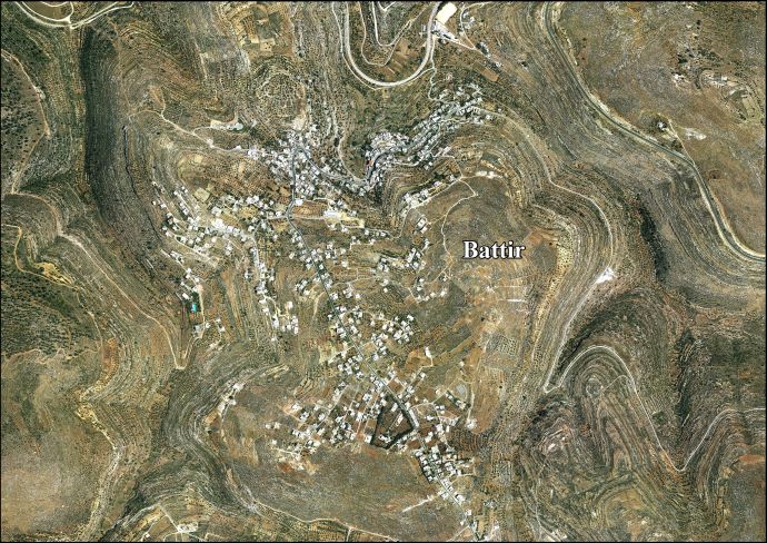
- Battir (Arabic: بتير) is a Palestinian village in the West Bank, 6.4 km west of Bethlehem, and southwest of Jerusalem. In 2017, the village had a population of 4,696. It was inhabited during the Byzantine and Islamic periods, and in the Ottoman and British Mandate censuses its population was recorded as primarily Muslim. In former times, the city lay along the route from Jerusalem to Bayt Jibrin. Battir is situated just above the modern route of the Jaffa–Jerusalem railway, which served as the armistice line between Israel and Jordan from 1949 until the Six-Day War, when it was occupied by Israel. In 2007, Battir had a population of about 4,000. In 2014, Battir was inscribed in the UNESCO World Heritage Site, as Land of Olives and Vines — Cultural Landscape of Southern Jerusalem, Battir. (en)
- Battir (en arabe بتير) est un village palestinien de Cisjordanie bâti sur le site de l'ancienne Betar. Le village est situé à 5 km à l'ouest de Bethléem et au sud-ouest de Jérusalem. Le site est occupé depuis l'âge du fer et c'est le lieu de la dernière bataille de la révolte de Bar Kokhba en 135. Le site est habité durant les périodes byzantines et ottomanes, et à l'époque du mandat britannique les habitants en sont enregistrés comme des musulmans. Battir est situé à proximité de la ligne de chemin de fer de Jaffa à Jérusalem, qui a servi de ligne d'armistice entre Israël et la Jordanie de 1949 jusqu'à la guerre des Six Jours, à l'issue de laquelle il a été occupé par Israël. Battir possède une population d'environ 4 000 personnes et dépend désormais de l'Autorité palestinienne. Les terrasses cultivées et le réseau d'irrigation sont classés au patrimoine mondial de l'UNESCO depuis 2014. (fr)
- Battir (en árabe, بتير) es un pueblo palestino localizado en Cisjordania, en la gobernación de Belén, a 5 km de Belén y al suroeste de Jerusalén. La localidad ya estuvo habitada durante los periodos bizantino e islámico, mientras que en los censos otomanos y británicos su población se manifestaba mayoritariamente musulmana. En el pasado, la aldea se ubicaba en la principal ruta que unía Jerusalén con , y actualmente se encuentra en la ruta del , que sirvió como línea de armisticio entre Israel y Jordania entre 1949 y 1967. Desde la Guerra de los Seis Días de 1967, Battir ha permanecido ocupada por Israel junto con el resto de Palestina. Tras la firma de los Acuerdos de Oslo en 1993, Battir se encuentra bajo la administración de la Autoridad Nacional Palestina. Tiene una población de aproximadamente 4.000 habitantes. En 2014, la Unesco proclamó el paisaje cultural de Battir como Patrimonio de la Humanidad, incluyéndolo en la lista del Patrimonio de la Humanidad en peligro. (es)
- Battir (bahasa Arab: بتير) adalah sebuah desa Palestina di Tepi Barat, 6.4 km dari barat Bethlehem, dan barat daya Yerusalem. , dinama nama Battir berasal, adalah desa dan benteng Yahudi abad kedua, situs pertempuran akhir pemberontakan Bar Kokhba. (in)
- Battir (in arabo بتير) è un villaggio palestinese di circa 4.000 abitanti, situato poco a sud di Gerusalemme. (it)
- Battir (Arabisch: بتير , ook geschreven als Bateer) is een Palestijnse plaats op de Westelijke Jordaanoever in de staat Palestina. Het valt onder de administratieve controle van het gouvernement Bethlehem. Battir ligt 6,4 km ten westen van Beit Jala en Bethlehem, 7 km ten zuidwesten van Jeruzalem. De plaats Al-Walaja ligt ten noorden ervan, in het zuiden en ten zuidoosten ervan. In het noorden en westen loopt de Groene Lijn, de wapenstilstandsgrens van 1949 tussen Israël en Jordanië.In 2007 woonden er volgens het Palestijns Centraal Bureau voor de Statistiek (PCBS) 3967 personen in 798 huishoudens in 981 huizen (nl)
- Battir (arab. بتير; hebr. בתיר) – wioska w muhafazie Betlejem w Autonomii Palestyńskiej. (pl)
- バティール(Battir, アラビア語: بتير)は、エルサレムの南西、ベツレヘムの西6.4キロメートルに位置するヨルダン川西岸地区のパレスチナの町である。町は古代にはベタル(Betar)の名で知られ、ユダヤのローマに対する戦争であるバル・コクバの乱の最後の戦場となった。現在の町はヤッファ=エルサレム線の鉄道路線沿いにあり、1949年からイスラエルによって占領された第三次中東戦争の時点まで、イスラエルとヨルダンの間の(グリーンライン)上に位置していた。 また、バティールには2,000年にわたって使用されてきた伝統的な灌漑システムと段々畑が存在する。2011年のパレスチナのユネスコ加盟後、パレスチナはバティールの文化的景観の世界遺産リスト登録を目指し、「オリーブとワインの地パレスチナ - エルサレム地方南部バティールの文化的景観」の名称で2014年に登録を果たした。 (ja)
- Battir (em árabe: بتير) é um povoado palestino localizado na Cisjordânia, na Província de Belém, a 5 quilômetros a sudoeste de Jerusalém Possui uma população de aproximadamente 4.000 habitantes e encontra-se sobre as vias férreas que comunicam Telavive e Jerusalém. Hoje em dia encontra-se sob a administração da Autoridade Nacional Palestina. (pt)
- 巴地尔(阿拉伯语:بتير),或译巴蒂尔,是巴勒斯坦約旦河西岸地區的一个村庄,位于伯利恒以西6.4千米,人口约4,000人。它在2014年以“巴勒斯坦:橄榄与葡萄树之地– 南耶路撒冷巴地尔”的名义列入联合国教科文组织世界文化遗产名录。其历史可以追溯至2世纪的一个犹太堡垒,现在还保留着罗马时代的灌溉设施。但现代的巴蒂尔是奥斯曼帝国统治时期才成型的。 (zh)
- Баттир — палестинская деревня, расположенная в 6,4 км к западу от Вифлеема и к юго-западу от Иерусалима, между городами Наблус и Хеврон. Население деревни по состоянию на 2007 год составляет (юридически) 3967 человек. В данной деревне используется уникальная система орошения небольших долин, представляющих своего рода каменные террасы, с помощью сети каналов, непосредственно питаемых от подземных источников воды. Некоторые из таких террас орошаются, и на них выращиваются различные овощные культуры. На тех участках террас, которые не орошаются, располагаются рощи оливковых деревьев и виноградные плантации. Ещё в 2011 году ЮНЕСКО выделило 15 тысяч долларов для целей сохранения ирригационной системы Баттира. 20 июня 2014 года культурный ландшафт, оливковые рощи и виноградники Баттира были включены в список Всемирного наследия ЮНЕСКО, будучи одновременно занесены также в список объектов Всемирного наследия, находящихся под угрозой уничтожения. Официальное название ЮНЕСКО на русском языке — Культурный ландшафт южной части Иерусалима, Батир (Палестина). (ru)
|
| rdfs:comment
|
- بتّير هي بلدة ريفية فلسطينية من قرى الريف الغربي لمحافظة بيت لحم، تمتاز بطبيعتها وبساتين الخضار التقليدية، كما أنها تشتهر . (ar)
- Batir (arabsky بتير) je arabská vesnice v Judských horách, 7 km jihozápadně od Jeruzaléma. Vesnice je součástí Palestinské autonomie (tzv. území B, pod částečnou izraelskou kontrolou). Jméno vesnice zachovává pojmenování starověkého pevnostního města Bejtar (hebrejsky ביתר, také přepisováno Betar), jež jako poslední vzdorovalo Římanům za povstání Bar Kochby. Jeho zbytky jsou identifikovány v Chirbet al-Jahúd uvnitř současné obce. Vesnice a okolní kulturní krajina jsou od června 2014 chráněny jako památka UNESCO. (cs)
- Battir (arabisch بتير, DMG Battīr) oder Betar (hebräisch בֵּיתַּר) ist eine südwestlich von Jerusalem gelegene Siedlung, die seit 2014 zum UNESCO-Weltkulturerbe gehört. In der Ortschaft leben circa 4500 Menschen. Es liegt nordöstlich von „Khirbet el-Yahud“ (dt. Ruine der Juden), einer archäologischen Stätte, die die Ruinen des antiken Betar (hebräisch בֵּיתַּר) umfasst. Der arabische Name Battir bewahrt den hebräischen Namen dieser altorientalischen Siedlung. In unmittelbarer Nähe befindet sich die israelische Kommune Betar Illit. (de)
- Battir (bahasa Arab: بتير) adalah sebuah desa Palestina di Tepi Barat, 6.4 km dari barat Bethlehem, dan barat daya Yerusalem. , dinama nama Battir berasal, adalah desa dan benteng Yahudi abad kedua, situs pertempuran akhir pemberontakan Bar Kokhba. (in)
- Battir (in arabo بتير) è un villaggio palestinese di circa 4.000 abitanti, situato poco a sud di Gerusalemme. (it)
- Battir (arab. بتير; hebr. בתיר) – wioska w muhafazie Betlejem w Autonomii Palestyńskiej. (pl)
- バティール(Battir, アラビア語: بتير)は、エルサレムの南西、ベツレヘムの西6.4キロメートルに位置するヨルダン川西岸地区のパレスチナの町である。町は古代にはベタル(Betar)の名で知られ、ユダヤのローマに対する戦争であるバル・コクバの乱の最後の戦場となった。現在の町はヤッファ=エルサレム線の鉄道路線沿いにあり、1949年からイスラエルによって占領された第三次中東戦争の時点まで、イスラエルとヨルダンの間の(グリーンライン)上に位置していた。 また、バティールには2,000年にわたって使用されてきた伝統的な灌漑システムと段々畑が存在する。2011年のパレスチナのユネスコ加盟後、パレスチナはバティールの文化的景観の世界遺産リスト登録を目指し、「オリーブとワインの地パレスチナ - エルサレム地方南部バティールの文化的景観」の名称で2014年に登録を果たした。 (ja)
- Battir (em árabe: بتير) é um povoado palestino localizado na Cisjordânia, na Província de Belém, a 5 quilômetros a sudoeste de Jerusalém Possui uma população de aproximadamente 4.000 habitantes e encontra-se sobre as vias férreas que comunicam Telavive e Jerusalém. Hoje em dia encontra-se sob a administração da Autoridade Nacional Palestina. (pt)
- 巴地尔(阿拉伯语:بتير),或译巴蒂尔,是巴勒斯坦約旦河西岸地區的一个村庄,位于伯利恒以西6.4千米,人口约4,000人。它在2014年以“巴勒斯坦:橄榄与葡萄树之地– 南耶路撒冷巴地尔”的名义列入联合国教科文组织世界文化遗产名录。其历史可以追溯至2世纪的一个犹太堡垒,现在还保留着罗马时代的灌溉设施。但现代的巴蒂尔是奥斯曼帝国统治时期才成型的。 (zh)
- Battir —en àrab بتير, Battīr— és un municipi palestí en la governació de Betlem al centre de Cisjordània, situat 6,4 kilòmetres a l'oest de Betlem. Segons l'Oficina Central d'Estadístiques de Palestina (PCBS), tenia una població de 4.993 habitants en 2016. Es troba a uns 760 m sobre el nivell del mar. (ca)
- Battir (Arabic: بتير) is a Palestinian village in the West Bank, 6.4 km west of Bethlehem, and southwest of Jerusalem. In 2017, the village had a population of 4,696. It was inhabited during the Byzantine and Islamic periods, and in the Ottoman and British Mandate censuses its population was recorded as primarily Muslim. In former times, the city lay along the route from Jerusalem to Bayt Jibrin. Battir is situated just above the modern route of the Jaffa–Jerusalem railway, which served as the armistice line between Israel and Jordan from 1949 until the Six-Day War, when it was occupied by Israel. In 2007, Battir had a population of about 4,000. (en)
- Battir (en árabe, بتير) es un pueblo palestino localizado en Cisjordania, en la gobernación de Belén, a 5 km de Belén y al suroeste de Jerusalén. La localidad ya estuvo habitada durante los periodos bizantino e islámico, mientras que en los censos otomanos y británicos su población se manifestaba mayoritariamente musulmana. En el pasado, la aldea se ubicaba en la principal ruta que unía Jerusalén con , y actualmente se encuentra en la ruta del , que sirvió como línea de armisticio entre Israel y Jordania entre 1949 y 1967. Desde la Guerra de los Seis Días de 1967, Battir ha permanecido ocupada por Israel junto con el resto de Palestina. Tras la firma de los Acuerdos de Oslo en 1993, Battir se encuentra bajo la administración de la Autoridad Nacional Palestina. Tiene una población de aprox (es)
- Battir (en arabe بتير) est un village palestinien de Cisjordanie bâti sur le site de l'ancienne Betar. Le village est situé à 5 km à l'ouest de Bethléem et au sud-ouest de Jérusalem. Le site est occupé depuis l'âge du fer et c'est le lieu de la dernière bataille de la révolte de Bar Kokhba en 135. Le site est habité durant les périodes byzantines et ottomanes, et à l'époque du mandat britannique les habitants en sont enregistrés comme des musulmans. (fr)
- Battir (Arabisch: بتير , ook geschreven als Bateer) is een Palestijnse plaats op de Westelijke Jordaanoever in de staat Palestina. Het valt onder de administratieve controle van het gouvernement Bethlehem. (nl)
- Баттир — палестинская деревня, расположенная в 6,4 км к западу от Вифлеема и к юго-западу от Иерусалима, между городами Наблус и Хеврон. Население деревни по состоянию на 2007 год составляет (юридически) 3967 человек. (ru)
|


