| dbo:PopulatedPlace/areaTotal
| |
| dbo:abstract
|
- Al-Khader, també al-Khadr (àrab: الخضر, al-Ḫadr), és un municipi palestí en la governació de Betlem al centre de Cisjordània, situat 5 kilòmetres a l'oest de Betlem. Segons l'Oficina Central d'Estadístiques de Palestina (PCBS), tenia una població de 12.301 habitants en 2016. L'àrea al voltant d'al-Khader és assenyalada amb vinyes, oliveres i figueres. La part més antiga d'al-Khader es troba en un turó en forma de muntanya que s'enfronta a una cresta escarpada cap al sud i zones obertes al nord, a les terres altes centrals de Cisjordània. Limita amb el camp de refugiats de Dheisheh a l'est, la vila d'Artas més a l'est, Beit Jala al nord-est, al-Walaja i l'assentament israelià de Har Gilo al nord, Battir i Husan al nord-oest, Nahalin i l'assentament de Beitar Illit a l'oest, l'assentament de Neve Daniel al sud-est, i l'assentament d'Elazar al sud. (ca)
- ( هذه المقالة عن الخضر القرية الفلسطينية فلسطين. لمعانٍ أخرى، طالع الخضر (توضيح).) الخضر بلدة فلسطينية تقع إلى الغرب من مدينة بيت لحم، وتبعد عنها حوالي 5 كيلومترات، يصلها طريق محلي يربطها بالطريق الرئيسي القدس – الخليل طوله 1.4كيلومتر، ترتفع عن سطح البحر 839 مترا، وتبلغ المساحة العمرانية للقرية 800 دونمًا، يدير شؤونها رئيس لبلدية، وترجع تسميتها إلى دير أقيم تخليدًا للقديس جورج/الخضر أقيم في المكان. (ar)
- Al-Khader (Arabic: الخضر) is a Palestinian town in the Bethlehem Governorate in the south-central West Bank. It is located 5 kilometers (3.1 mi) west of Bethlehem. According to the Palestinian Central Bureau of Statistics, the town had a population of 11,856 in 2017. The area around al-Khader is marked by vineyards, and olive and fig trees. Solomon's Pools, the Monastery of St. George, and Al-Hamadiyya Mosque are al-Khader's main landmarks. (en)
- Al-Khader (en árabe: الخضر) es un pueblo palestino de la Gobernación de Belén, en el centro-sur de Cisjordania. Se encuentra a 5 kilómetros (3,1 millas) al oeste de Belén. Según la Oficina Central de Estadísticas de Palestina, la ciudad tenía una población de 9.774 habitantes en 2007. (es)
- Al-Khader (in arabo الخضر) è una città palestinese del Governatorato di Betlemme nella parte sud della West Bank. Si trova a 5 km ad ovest di Betlemme. Secondo il Palestinian Central Bureau of Statistics, la città aveva 9.774 abitanti nel 2007. (it)
- Al-Chadr (arab. الخضر) – miasto w Autonomii Palestyńskiej (środkowy Zachodni Brzeg, muhafaza Betlejem). Według danych oficjalnych na rok 2007 liczyło 9651 mieszkańców. (pl)
|
| dbo:areaTotal
|
- 19900000.000000 (xsd:double)
|
| dbo:country
| |
| dbo:governmentType
| |
| dbo:politicalLeader
| |
| dbo:populationTotal
|
- 11960 (xsd:nonNegativeInteger)
|
| dbo:subdivision
| |
| dbo:thumbnail
| |
| dbo:wikiPageExternalLink
| |
| dbo:wikiPageID
| |
| dbo:wikiPageLength
|
- 26065 (xsd:nonNegativeInteger)
|
| dbo:wikiPageRevisionID
| |
| dbo:wikiPageWikiLink
| |
| dbp:areaTotalDunam
| |
| dbp:areaTotalKm
| |
| dbp:blankInfoSec
|
- "the [town] of Saint George" (en)
|
| dbp:blankNameSec
| |
| dbp:establishedTitle
| |
| dbp:governmentType
| |
| dbp:gridName
| |
| dbp:gridPosition
| |
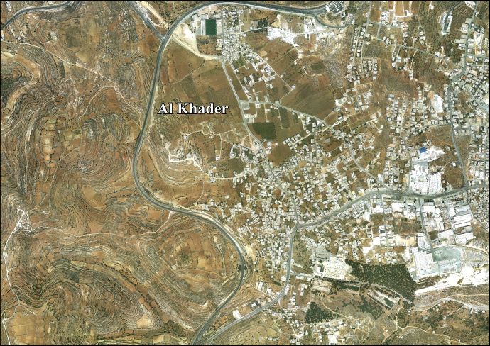
| dbp:imageCaption
|
- Eastern al-Khader and Solomon's Pools (en)
|
| dbp:imageSkyline
| |
| dbp:leaderName
| |
| dbp:leaderTitle
|
- Head of Municipality (en)
|
| dbp:name
| |
| dbp:populationAsOf
| |
| dbp:populationDensityKm
| |
| dbp:populationTotal
| |
| dbp:pushpinMap
| |
| dbp:pushpinMapCaption
|
- Location of al-Khader within Palestine (en)
|
| dbp:subdivisionName
| |
| dbp:subdivisionType
| |
| dbp:translitLang
| |
| dbp:translitLang1Info
| |
| dbp:translitLang1Type
| |
| dbp:type
| |
| dbp:unitPref
| |
| dbp:wikiPageUsesTemplate
| |
| dcterms:subject
| |
| gold:hypernym
| |
| georss:point
|
- 31.692777777777778 35.16638888888889
|
| rdf:type
| |
| rdfs:comment
|
- ( هذه المقالة عن الخضر القرية الفلسطينية فلسطين. لمعانٍ أخرى، طالع الخضر (توضيح).) الخضر بلدة فلسطينية تقع إلى الغرب من مدينة بيت لحم، وتبعد عنها حوالي 5 كيلومترات، يصلها طريق محلي يربطها بالطريق الرئيسي القدس – الخليل طوله 1.4كيلومتر، ترتفع عن سطح البحر 839 مترا، وتبلغ المساحة العمرانية للقرية 800 دونمًا، يدير شؤونها رئيس لبلدية، وترجع تسميتها إلى دير أقيم تخليدًا للقديس جورج/الخضر أقيم في المكان. (ar)
- Al-Khader (Arabic: الخضر) is a Palestinian town in the Bethlehem Governorate in the south-central West Bank. It is located 5 kilometers (3.1 mi) west of Bethlehem. According to the Palestinian Central Bureau of Statistics, the town had a population of 11,856 in 2017. The area around al-Khader is marked by vineyards, and olive and fig trees. Solomon's Pools, the Monastery of St. George, and Al-Hamadiyya Mosque are al-Khader's main landmarks. (en)
- Al-Khader (en árabe: الخضر) es un pueblo palestino de la Gobernación de Belén, en el centro-sur de Cisjordania. Se encuentra a 5 kilómetros (3,1 millas) al oeste de Belén. Según la Oficina Central de Estadísticas de Palestina, la ciudad tenía una población de 9.774 habitantes en 2007. (es)
- Al-Khader (in arabo الخضر) è una città palestinese del Governatorato di Betlemme nella parte sud della West Bank. Si trova a 5 km ad ovest di Betlemme. Secondo il Palestinian Central Bureau of Statistics, la città aveva 9.774 abitanti nel 2007. (it)
- Al-Chadr (arab. الخضر) – miasto w Autonomii Palestyńskiej (środkowy Zachodni Brzeg, muhafaza Betlejem). Według danych oficjalnych na rok 2007 liczyło 9651 mieszkańców. (pl)
- Al-Khader, també al-Khadr (àrab: الخضر, al-Ḫadr), és un municipi palestí en la governació de Betlem al centre de Cisjordània, situat 5 kilòmetres a l'oest de Betlem. Segons l'Oficina Central d'Estadístiques de Palestina (PCBS), tenia una població de 12.301 habitants en 2016. L'àrea al voltant d'al-Khader és assenyalada amb vinyes, oliveres i figueres. (ca)
|
| rdfs:label
|
- Al-Khader (en)
- الخضر (بيت لحم) (ar)
- Al-Khader (ca)
- Al-Khadr (es)
- Al-Khader (it)
- Al-Chadr (pl)
|
| owl:sameAs
| |
| geo:geometry
|
- POINT(35.166389465332 31.692777633667)
|
| geo:lat
| |
| geo:long
| |
| prov:wasDerivedFrom
| |
| foaf:depiction
| |
| foaf:isPrimaryTopicOf
| |
| foaf:name
| |
| is dbo:location
of | |
| is dbo:wikiPageRedirects
of | |
| is dbo:wikiPageWikiLink
of | |
| is dbp:location
of | |
| is foaf:primaryTopic
of | |


