| dbo:abstract
|
- Cleeve Hill (també conegut com a Cleeve Cloud) és el punt més alt de la serralada dels Cotswolds i dins el comtat de Gloucestershire, amb 1,083 peus (330 m). Des d'aquest punt es pot veure el Riu Severn i Gal·les; i al nord fins Winchcombe. Cleeve Hill, que es tracta d'una muntanya d'origen sedimentari del Juràssic, és el punt més alt de la conca del Riu Tàmesi. Cleeve Common, el qual està situat a Cleeve Hill, està designat com lloc d'especial interès científic (Site of Special Scientific Interest) per la (ca)
- تلة كليف (بالإنجليزية: Cleeve Hill) هي أعلى نقطة في سلسلة الكوتسوولدز. يبلغ ارتفاعها 330 مترا. (ar)
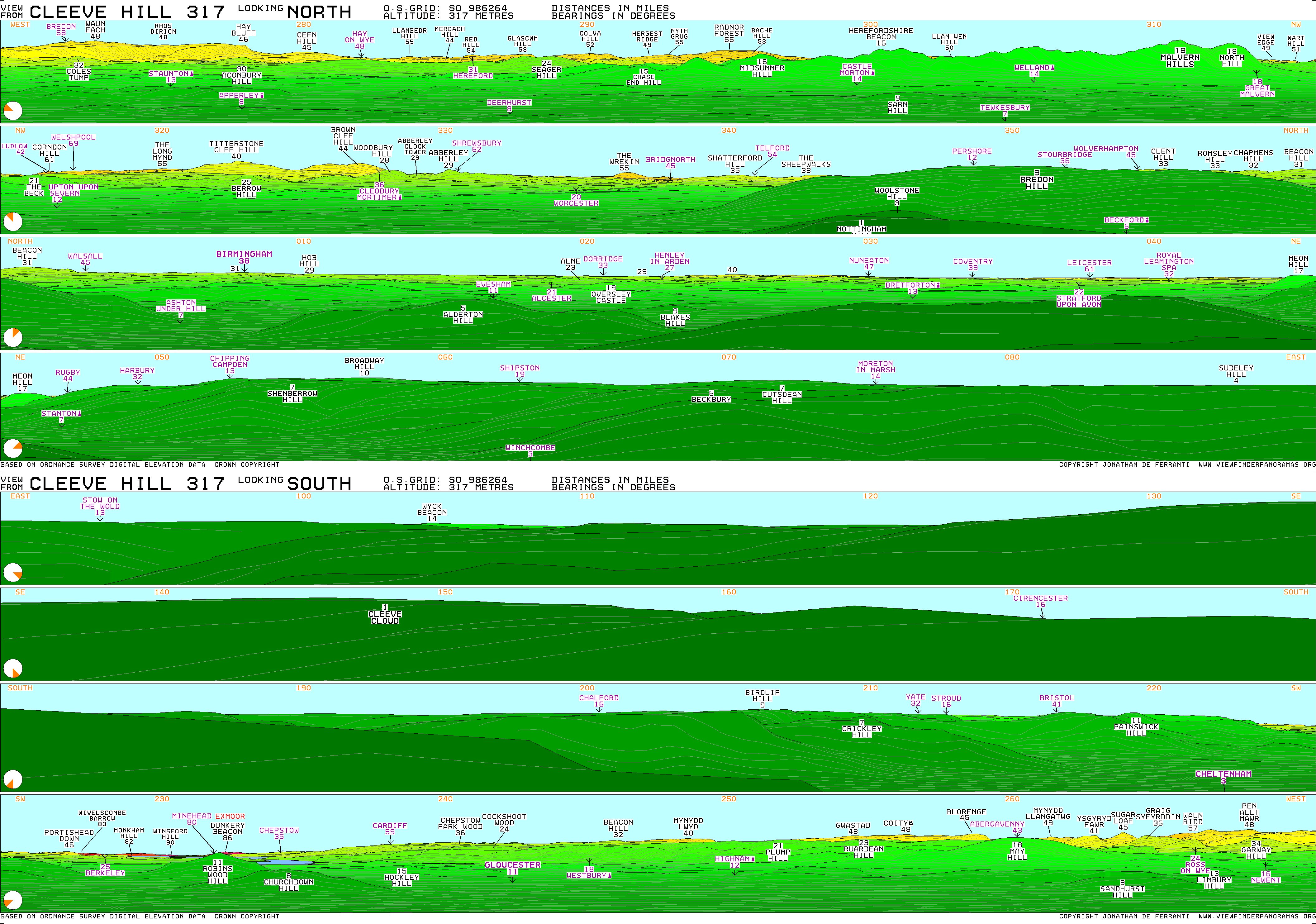
- Cleeve Hill (also known as Cleeve Cloud) is the highest point both of the Cotswolds hill range and of the county of Gloucestershire, at 330 m (1,080 ft). It is located on Cleeve Common which is a Site of Special Scientific Interest (SSSI) looked after by a small charity called Cleeve Common Trust (formally Cleeve Common Board of Conservators). It commands a clear view to the west, over Cheltenham and the racecourse, over the River Severn and into Wales; and to the north over Winchcombe. It is a conspicuous outcrop on the edge of the limestone escarpment, (sometimes called the "Cotswold Edge"). It is crossed by the Cotswold Way footpath. With the hill's south slopes draining to the River Coln, Cleeve Hill is the highest point in the drainage basin of the River Thames. (en)
- Is cnoc i Sasana ė Cleeve Hill, atá suite i gGloucestershire. (ga)
- Cleeve Hill, ou Cleeve Common, ou encore Cleeve Cloud, est un sommet du Royaume-Uni culminant à 330 mètres d'altitude dans le comté du Gloucestershire, dont il constitue le point culminant, en Angleterre. C'est également le plus haut sommet des Cotswolds. (fr)
- Cleeve Hill är en kulle i Storbritannien. Den ligger i grevskapet Gloucestershire och riksdelen England, i den södra delen av landet, 140 km väster om huvudstaden London. Toppen på Cleeve Hill är 312 meter över havet. Terrängen runt Cleeve Hill är platt åt nordväst, men åt sydost är den kuperad. Den högsta punkten i närheten är 329 meter över havet, 1,9 km sydost om Cleeve Hill. Runt Cleeve Hill är det ganska tätbefolkat, med 72 invånare per kvadratkilometer. Närmaste större samhälle är Gloucester, 17,1 km sydväst om Cleeve Hill. Trakten runt Cleeve Hill består till största delen av jordbruksmark. Kustklimat råder i trakten. Årsmedeltemperaturen i trakten är 8 °C. Den varmaste månaden är juli, då medeltemperaturen är 16 °C, och den kallaste är januari, med 0 °C. (sv)
|
| dbo:elevation
| |
| dbo:locatedInArea
| |
| dbo:mountainRange
| |
| dbo:nationalTopographicSystemMapNumber
|
- OSExplorer 179
- OSLandranger 163
|
| dbo:prominence
| |
| dbo:thumbnail
| |
| dbo:wikiPageExternalLink
| |
| dbo:wikiPageID
| |
| dbo:wikiPageLength
|
- 5913 (xsd:nonNegativeInteger)
|
| dbo:wikiPageRevisionID
| |
| dbo:wikiPageWikiLink
| |
| dbp:age
| |
| dbp:easiestRoute
| |
| dbp:elevationM
| |
| dbp:gridRefUk
| |
| dbp:labelPosition
| |
| dbp:listing
| |
| dbp:location
| |
| dbp:mapCaption
|
- Cleeve Hill in Gloucestershire (en)
|
| dbp:mapSize
| |
| dbp:name
| |
| dbp:parentPeak
| |
| dbp:photo
| |
| dbp:photoCaption
|
- The trig point on the northern part of Cleeve Hill at SO985263. There is also a toposcope at this location (en)
|
| dbp:prominenceM
| |
| dbp:range
| |
| dbp:topo
|
- OS Landranger 163
OS Explorer 179 (en)
|
| dbp:type
| |
| dbp:wikiPageUsesTemplate
| |
| dcterms:subject
| |
| georss:point
| |
| rdf:type
| |
| rdfs:comment
|
- Cleeve Hill (també conegut com a Cleeve Cloud) és el punt més alt de la serralada dels Cotswolds i dins el comtat de Gloucestershire, amb 1,083 peus (330 m). Des d'aquest punt es pot veure el Riu Severn i Gal·les; i al nord fins Winchcombe. Cleeve Hill, que es tracta d'una muntanya d'origen sedimentari del Juràssic, és el punt més alt de la conca del Riu Tàmesi. Cleeve Common, el qual està situat a Cleeve Hill, està designat com lloc d'especial interès científic (Site of Special Scientific Interest) per la (ca)
- تلة كليف (بالإنجليزية: Cleeve Hill) هي أعلى نقطة في سلسلة الكوتسوولدز. يبلغ ارتفاعها 330 مترا. (ar)
- Is cnoc i Sasana ė Cleeve Hill, atá suite i gGloucestershire. (ga)
- Cleeve Hill, ou Cleeve Common, ou encore Cleeve Cloud, est un sommet du Royaume-Uni culminant à 330 mètres d'altitude dans le comté du Gloucestershire, dont il constitue le point culminant, en Angleterre. C'est également le plus haut sommet des Cotswolds. (fr)
- Cleeve Hill (also known as Cleeve Cloud) is the highest point both of the Cotswolds hill range and of the county of Gloucestershire, at 330 m (1,080 ft). It is located on Cleeve Common which is a Site of Special Scientific Interest (SSSI) looked after by a small charity called Cleeve Common Trust (formally Cleeve Common Board of Conservators). It commands a clear view to the west, over Cheltenham and the racecourse, over the River Severn and into Wales; and to the north over Winchcombe. It is a conspicuous outcrop on the edge of the limestone escarpment, (sometimes called the "Cotswold Edge"). It is crossed by the Cotswold Way footpath. (en)
- Cleeve Hill är en kulle i Storbritannien. Den ligger i grevskapet Gloucestershire och riksdelen England, i den södra delen av landet, 140 km väster om huvudstaden London. Toppen på Cleeve Hill är 312 meter över havet. Kustklimat råder i trakten. Årsmedeltemperaturen i trakten är 8 °C. Den varmaste månaden är juli, då medeltemperaturen är 16 °C, och den kallaste är januari, med 0 °C. (sv)
|
| rdfs:label
|
- تلة كليف (ar)
- Cleeve Hill (ca)
- Cleeve Hill, Gloucestershire (en)
- Cleeve Hill (ga)
- Cleeve Hill (fr)
- Cleeve Hill (sv)
|
| owl:sameAs
| |
| geo:geometry
|
- POINT(-2.0069999694824 51.919998168945)
|
| geo:lat
| |
| geo:long
| |
| prov:wasDerivedFrom
| |
| foaf:depiction
| |
| foaf:homepage
| |
| foaf:isPrimaryTopicOf
| |
| foaf:name
| |
| is dbo:deathPlace
of | |
| is dbo:wikiPageDisambiguates
of | |
| is dbo:wikiPageRedirects
of | |
| is dbo:wikiPageWikiLink
of | |
| is dbp:deathPlace
of | |
| is dbp:parentPeak
of | |
| is dbp:source
of | |
| is foaf:primaryTopic
of | |


