| dbo:PopulatedPlace/areaTotal
| |
| dbo:abstract
|
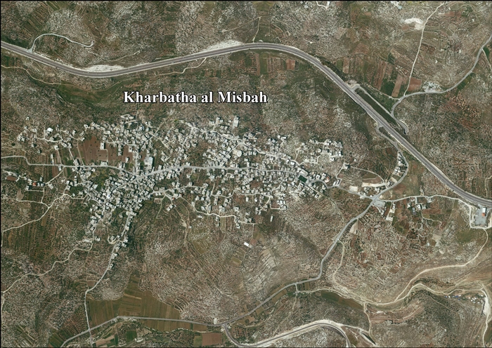
- Kharbatha al-Misbah—en àrab خربثا المصباح, Ḫarbaṯa al-Miṣbāḥ, «ruïnes de la llum»— és una vila palestina de la governació de Ramal·lah i al-Bireh, al centre de Cisjordània, situada 15 km a l'oest de Ramal·lah. Segons l'Oficina Central d'Estadístiques de Palestina (PCBS), tenia una població de 6.668 habitants en 2016. Limita amb Beit Liqya al sud i Beit Ur al-Tahta a l'est. La seva àrea és de 4,431 dúnams, dels quals 644 són àrea edificada i la resta pastures, terra llaurada o forestes. (ca)
- خربثا المصباح هي بلدة فلسطينية في وسط الضفة الغربية، وتقع على 12.5 كيلومتر (7.8 ميل) غرب مدينة رام الله في محافظة رام الله والبيرة. وفقًا للجهاز المركزي للإحصاء الفلسطيني، كان عدد سكان البلدة 5,211 نسمة في عام 2007. وتبلغ مساحتها الإجمالية 4,431 دونمًا، منها 644 دونمًا منطقة عمرانية والباقي أراض زراعية وغابات. (ar)
- Kharbatha al-Misbah (Arabic: خربثا المصباح) is a Palestinian town in the central West Bank, located 12.5 kilometers (7.8 mi) west of Ramallah in the Ramallah and al-Bireh Governorate. According to the Palestinian Central Bureau of Statistics, the town had a population of 5,211 in 2007. It has a total land area of 4,431 dunams, of which 644 are built-up areas and the remainder agricultural lands and forests. (en)
- Charbata al-Misbah (arab. خربثا المصباح, Ḫarbaṯa al-Miṣbāḥ) – wieś w Palestynie, w muhafazie Ramallah i Al-Bira. Według danych szacunkowych Palestyńskiego Centralnego Biura Statystycznego w 2016 roku miejscowość liczyła 6668 mieszkańców. (pl)
|
| dbo:areaTotal
|
- 4400000.000000 (xsd:double)
|
| dbo:country
| |
| dbo:elevation
| |
| dbo:governmentType
| |
| dbo:politicalLeader
| |
| dbo:populationTotal
|
- 5211 (xsd:nonNegativeInteger)
|
| dbo:subdivision
| |
| dbo:thumbnail
| |
| dbo:wikiPageExternalLink
| |
| dbo:wikiPageID
| |
| dbo:wikiPageLength
|
- 14701 (xsd:nonNegativeInteger)
|
| dbo:wikiPageRevisionID
| |
| dbo:wikiPageWikiLink
| |
| dbp:areaTotalDunam
| |
| dbp:areaTotalKm
| |
| dbp:blankInfoSec
|
- "The Ruins of the son of the wild beast, or "of seven"" (en)
|
| dbp:blankNameSec
| |
| dbp:elevationM
| |
| dbp:establishedTitle
| |
| dbp:governmentType
| |
| dbp:gridName
| |
| dbp:gridPosition
| |
| dbp:imageCaption
|
- Kharbatha al-Misbah, east entrance (en)
|
| dbp:imageSkyline
|
- File:Misbach7752.JPG (en)
|
| dbp:leaderName
|
- Sa'di Jabir Ibrahim Daraj (en)
|
| dbp:leaderTitle
|
- Head of Municipality (en)
|
| dbp:name
| |
| dbp:populationAsOf
| |
| dbp:populationDensityKm
| |
| dbp:populationTotal
| |
| dbp:pushpinMap
| |
| dbp:pushpinMapCaption
|
- Location of Kharbatha al-Misbah within Palestine (en)
|
| dbp:subdivisionName
| |
| dbp:subdivisionType
| |
| dbp:translitLang
| |
| dbp:translitLang1Info
|
- Kharbatha al-Misbah (en)
- Khirbet al-Misbah, Khurbetha ibn es Seba (en)
- خربثا المصباح (en)
|
| dbp:translitLang1Type
| |
| dbp:type
| |
| dbp:unitPref
| |
| dbp:wikiPageUsesTemplate
| |
| dcterms:subject
| |
| gold:hypernym
| |
| georss:point
|
- 31.884722222222223 35.071666666666665
|
| rdf:type
| |
| rdfs:comment
|
- Kharbatha al-Misbah—en àrab خربثا المصباح, Ḫarbaṯa al-Miṣbāḥ, «ruïnes de la llum»— és una vila palestina de la governació de Ramal·lah i al-Bireh, al centre de Cisjordània, situada 15 km a l'oest de Ramal·lah. Segons l'Oficina Central d'Estadístiques de Palestina (PCBS), tenia una població de 6.668 habitants en 2016. Limita amb Beit Liqya al sud i Beit Ur al-Tahta a l'est. La seva àrea és de 4,431 dúnams, dels quals 644 són àrea edificada i la resta pastures, terra llaurada o forestes. (ca)
- خربثا المصباح هي بلدة فلسطينية في وسط الضفة الغربية، وتقع على 12.5 كيلومتر (7.8 ميل) غرب مدينة رام الله في محافظة رام الله والبيرة. وفقًا للجهاز المركزي للإحصاء الفلسطيني، كان عدد سكان البلدة 5,211 نسمة في عام 2007. وتبلغ مساحتها الإجمالية 4,431 دونمًا، منها 644 دونمًا منطقة عمرانية والباقي أراض زراعية وغابات. (ar)
- Kharbatha al-Misbah (Arabic: خربثا المصباح) is a Palestinian town in the central West Bank, located 12.5 kilometers (7.8 mi) west of Ramallah in the Ramallah and al-Bireh Governorate. According to the Palestinian Central Bureau of Statistics, the town had a population of 5,211 in 2007. It has a total land area of 4,431 dunams, of which 644 are built-up areas and the remainder agricultural lands and forests. (en)
- Charbata al-Misbah (arab. خربثا المصباح, Ḫarbaṯa al-Miṣbāḥ) – wieś w Palestynie, w muhafazie Ramallah i Al-Bira. Według danych szacunkowych Palestyńskiego Centralnego Biura Statystycznego w 2016 roku miejscowość liczyła 6668 mieszkańców. (pl)
|
| rdfs:label
|
- خربثا المصباح (ar)
- Kharbatha al-Misbah (ca)
- Kharbatha al-Misbah (en)
- Charbata al-Misbah (pl)
|
| owl:sameAs
| |
| geo:geometry
|
- POINT(35.071666717529 31.884721755981)
|
| geo:lat
| |
| geo:long
| |
| prov:wasDerivedFrom
| |
| foaf:depiction
| |
| foaf:isPrimaryTopicOf
| |
| foaf:name
| |
| is dbo:wikiPageRedirects
of | |
| is dbo:wikiPageWikiLink
of | |
| is foaf:primaryTopic
of | |


