| dbo:abstract
|
- Beitillu (àrab: بيتللو, Baytillū) és un antic municipi palestí en la governació de Ramal·lah i al-Bireh al centre de Cisjordània, situat 19 kilòmetres al nord-oest de Ramal·lah. Segons l'Oficina Central d'Estadístiques de Palestina (PCBS), tenia una població de 3.083 habitants en 2006. Des de 1997 forma part del nou municipi d'Al-Ittihad. (ca)
- بيتللو قرية فلسطينية من قرى الضفة الغربية في محافظة رام الله والبيرة، تقع إلى الشمال من القدس. بلغ عدد سكانها حوالي 3,465 نسمة (لا يشمل المغتربين) حسب التعداد العام للسكان والمساكن والمنشآت عام 2017. وهي من القرى المحتلة في حرب عام 1967. (ar)
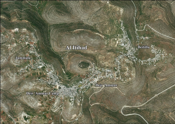
- Beitillu (Arabic: بيت إللو) is a Palestinian town located in the Ramallah and al-Bireh Governorate in the northern West Bank, 19 kilometers Northwest of Ramallah. According to the Palestinian Central Bureau of Statistics, it had a population of approximately 3,083 in mid-year 2006 Presently much of the villagers' traditional land, springs, gardens with olive and fig trees, near the Israeli settlement of Nachliel cannot be accessed, because their way is barred by Israeli soldiers or settlers, often with dogs. Beitillu, together with Deir 'Ammar and Jammala, form the new town of Al-Ittihad. (en)
|
| dbo:country
| |
| dbo:elevation
| |
| dbo:governmentType
| |
| dbo:populationTotal
|
- 3083 (xsd:nonNegativeInteger)
|
| dbo:subdivision
| |
| dbo:thumbnail
| |
| dbo:wikiPageExternalLink
| |
| dbo:wikiPageID
| |
| dbo:wikiPageLength
|
- 17578 (xsd:nonNegativeInteger)
|
| dbo:wikiPageRevisionID
| |
| dbo:wikiPageWikiLink
| |
| dbp:blankInfoSec
| |
| dbp:blankNameSec
| |
| dbp:elevationM
| |
| dbp:establishedTitle
| |
| dbp:governmentType
| |
| dbp:gridName
| |
| dbp:gridPosition
| |
| dbp:imageCaption
| |
| dbp:imageSkyline
|
- قرية بيتللو فلسطين.JPG (en)
|
| dbp:name
| |
| dbp:populationAsOf
| |
| dbp:populationDensityKm
| |
| dbp:populationTotal
| |
| dbp:pushpinMap
| |
| dbp:pushpinMapCaption
|
- Location of Beitillu within Palestine (en)
|
| dbp:subdivisionName
| |
| dbp:subdivisionType
| |
| dbp:translitLang
| |
| dbp:translitLang1Info
|
- Beitillu (en)
- بيت إللو (en)
|
| dbp:translitLang1Type
| |
| dbp:type
| |
| dbp:unitPref
| |
| dbp:wikiPageUsesTemplate
| |
| dcterms:subject
| |
| gold:hypernym
| |
| georss:point
|
- 31.975833333333334 35.115
|
| rdf:type
| |
| rdfs:comment
|
- Beitillu (àrab: بيتللو, Baytillū) és un antic municipi palestí en la governació de Ramal·lah i al-Bireh al centre de Cisjordània, situat 19 kilòmetres al nord-oest de Ramal·lah. Segons l'Oficina Central d'Estadístiques de Palestina (PCBS), tenia una població de 3.083 habitants en 2006. Des de 1997 forma part del nou municipi d'Al-Ittihad. (ca)
- بيتللو قرية فلسطينية من قرى الضفة الغربية في محافظة رام الله والبيرة، تقع إلى الشمال من القدس. بلغ عدد سكانها حوالي 3,465 نسمة (لا يشمل المغتربين) حسب التعداد العام للسكان والمساكن والمنشآت عام 2017. وهي من القرى المحتلة في حرب عام 1967. (ar)
- Beitillu (Arabic: بيت إللو) is a Palestinian town located in the Ramallah and al-Bireh Governorate in the northern West Bank, 19 kilometers Northwest of Ramallah. According to the Palestinian Central Bureau of Statistics, it had a population of approximately 3,083 in mid-year 2006 Presently much of the villagers' traditional land, springs, gardens with olive and fig trees, near the Israeli settlement of Nachliel cannot be accessed, because their way is barred by Israeli soldiers or settlers, often with dogs. Beitillu, together with Deir 'Ammar and Jammala, form the new town of Al-Ittihad. (en)
|
| rdfs:label
|
- Beitillu (en)
- بيتللو (ar)
- Beitillu (ca)
|
| owl:sameAs
| |
| geo:geometry
|
- POINT(35.115001678467 31.975833892822)
|
| geo:lat
| |
| geo:long
| |
| prov:wasDerivedFrom
| |
| foaf:depiction
| |
| foaf:isPrimaryTopicOf
| |
| foaf:name
| |
| is dbo:wikiPageRedirects
of | |
| is dbo:wikiPageWikiLink
of | |
| is foaf:primaryTopic
of | |
%D9%81%D9%84%D8%B3%D8%B7%D9%8A%D9%86.jpg?width=300)


فلسطين.jpg?width=300)
فلسطين.jpg)