| dbo:abstract
|
- Al-Ram (àrab: الرّام, ar-Rām), oficialment Ar Ram & Dahiyat al Bar, és una ciutat palestina de la governació de Jerusalem, a Cisjordània, situada 8,1 kilòmetres al nord de Jerusalem. Forma part de l'àrea urbana urbanitzada de Jerusalem, la zona industrial d' i Beit Hanina es troben cap a l'oest, i la limita al sud. Té una àrea edificada de 3.289 dúnams. Segons l'Oficina Central Palestina d'Estadístiques tenia una població de 23.800 habitants el 2016. El cap del consell municipal d'ar-Ram village estima que hi viuen 58.000 persones, i que més de la meitat d'ells porten targetes d'identitat israelianes. (ca)
- الرام تقع 8 كم إلى الشمال من القدس وتغطى مساحة وتصل غلى 6708 دونماً، منها 2613 دونماً مبنية. ترتفع الرام 750 متراً عن سطح البحر. تحدّها من الشرق قرية جبع، من الشمال كفر عقب ومخيم قلنديا، ومن الغرب بير نبالا، ومن الجنوب بيت حنينا. وتعتبر منطقة «ضاحية البريد» الحيّ الجنوبي لقرية الرام، وهي محاطة بالمستعمرات من ثلاث جهات: «بسغات زئيف» من الجنوب، «النفيه يعكوف» من الجنوب الشرقي، و«جفعات بنيامين» من الشرق. وفقاً لمجلس محلي الرام، فإن مساحة ضاحية البريد ما يقارب 1000 دونم يسكنها ما يقارب 5000 نسمة. اقتطع جدار الضمّ والتوسع مساحة من ضاحية البريد وأصبحت في الجهة التي تخضع للسيطرة الإسرائيلية الأمنية (أي أضيفت إلى منطقة القدس)، دون أن تضمّ إلى نفوذ بلدية الاحتلال في القدس. وتقع في هذه المنطقة مكاتب عدد من مؤسسات المجتمع المدنيّ الدّولية. (ar)
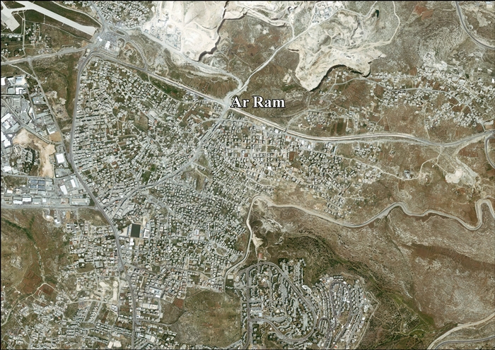
- Al-Ram (Arabic: الرّام), also transcribed as Al-Ramm, El-Ram, Er-Ram, and A-Ram, is a Palestinian town which lies northeast of Jerusalem, just outside the city's municipal border. The village is part of the built-up urban area of Jerusalem, the Atarot industrial zone and Beit Hanina lie to the west, and Neve Yaakov borders it on the south, with a built-up area of 3,289 dunums. According to the Palestinian Central Bureau of Statistics, a-Ram had a population of 25,595 in 2006. The head of A-Ram's village council estimates that 58,000 people live there, more than half of them holding Israeli identity cards. (en)
- Al-Ram (en árabe: الرام), también transcrito Al-Ramm, Ar-Ram o A-Ram, es una ciudad palestina que se encuentra al noreste de Jerusalén, a las afueras de la frontera municipal de la ciudad. El pueblo es parte del área urbana urbanizada de Jerusalén y linda con la zona industrial de Atarot y el barrio de Jerusalén Este Beit Hanina al oeste, con el asentamiento israelí de al sur y con el pueblo palestino de Kalandia al norte. Tiene un área construida de 3289 dunams. Según la Oficina Central de Estadísticas de Palestina, al-Ram tenía una población de 25.595 habitantes en 2006. Antes de la construcción del muro de separación, el pueblo era un barrio de las afueras de Jerusalén Este con la que tradicionalmente mantenía estrechas relaciones familiares, laborales, educativas, culturales y sanitarias. Pero, al igual que pasó con otras poblaciones palestinas cercanas como al-Azariya, Abu Dis and , el trazado del muro ha aislado Al-Ram no solo de Jerusalén sino también de los pueblos palestinos vecinos, diseccionando el espacio palestino. El jefe del consejo municipal de Al-Ram consideraba en 2005 que 58.000 personas residían allí, más de la mitad de ellas con documentos de identidad israelíes. Antes de que finalizara la construcción del muro de separación, miles de ellas se trasladaron a Jerusalén Este. (es)
- A-Ram ' atau al-Ramm ' (bahasa Arab: الرّام;) adalah kota Palestina yang terletak di timur laut Yerusalem, tepat di luar perbatasan kota. Desa ini adalah bagian dari kawasan perkotaan Yerusalem, dan zona industri Atarot dan Beit Hanina terletak di Barat, dan berbatasan di Selatan. dengan luas bangunan 3,289 dunums. Menurut , a-Ram memiliki populasi 25,595 pada tahun 2006. Kepala dewan desa a-Ram memperkirakan bahwa 58,000 orang tinggal disana, lebih dari setengah dari mereka memegang kartu identitas Israel. (in)
- 알람(아랍어: الرّام)은 팔레스타인 요르단강 서안 지구에 위치한 도시로 면적은 3.3km2, 인구는 25,595명(2006년 기준)이다. 예루살렘의 북동쪽에 위치하며 행정 구역상으로는 예루살렘주에 속한다. 고대에 작성된 성경, 중세 시대에 예루살렘 원정에 나섰던 십자군의 문헌에 등장할 정도로 오랜 역사를 갖고 있으며 1161년에 마을이 형성되었다. (ko)
- Al-Ram, conosciuta anche come A-Ram, Er-Ram o al-Ramm, è una città dei territori palestinesi, sita a circa sette chilometri a NE di Gerusalemme. (it)
- Ar-Ram/Ar-Ramah, officieel Ar Ram & Dahiyat al Bareed (Arabisch: الرامّ ) is een Palestijnse stad op de Westelijke Jordaanoever, gelegen in het gouvernement Jeruzalem.Het ligt 8,1 km ten noorden van de Jeruzalem, en grenst in het oosten aan , in het noorden aan en (vluchtelingenkamp), in het westen aan en in het zuiden aan . De meeste van deze Palestijnse dorpen en stadjes van de Palestijnse Autoriteit zijn kort na Zesdaagse Oorlog van 1967 door de Israëlische regering tegelijk met Oost-Jeruzalem wederrechtelijk geannexeerd en onder bestuur van Israëlische gemeente Jeruzalem gebracht. Door Israël is een groot deel van de landerijen en grondgebied van Ar-Ram geconfisqueerd voor diverse Israëlische doelen als de bouw van Israëlische nederzettingen en industrie, militaire bases, Israëlische snelwegen (zogenoemde 'bypass-roads'), militaire controleposten (checkpoints) en bufferzones. De confiscaties en annexatie van door Israël bezet Palestijns gebied zijn door diverse Resoluties van de Verenigde Naties en de Veiligheidsraad veroordeeld, zoals onder meer Resolutie 478 Veiligheidsraad Verenigde Naties. (nl)
- Ar-Ram (arab. الرامّ) – miasto w Autonomii Palestyńskiej (Zachodni Brzeg). Według danych szacunkowych na rok 2008 liczy 33 940 mieszkańców. (pl)
|
| rdfs:comment
|
- Al-Ram (àrab: الرّام, ar-Rām), oficialment Ar Ram & Dahiyat al Bar, és una ciutat palestina de la governació de Jerusalem, a Cisjordània, situada 8,1 kilòmetres al nord de Jerusalem. Forma part de l'àrea urbana urbanitzada de Jerusalem, la zona industrial d' i Beit Hanina es troben cap a l'oest, i la limita al sud. Té una àrea edificada de 3.289 dúnams. Segons l'Oficina Central Palestina d'Estadístiques tenia una població de 23.800 habitants el 2016. El cap del consell municipal d'ar-Ram village estima que hi viuen 58.000 persones, i que més de la meitat d'ells porten targetes d'identitat israelianes. (ca)
- الرام تقع 8 كم إلى الشمال من القدس وتغطى مساحة وتصل غلى 6708 دونماً، منها 2613 دونماً مبنية. ترتفع الرام 750 متراً عن سطح البحر. تحدّها من الشرق قرية جبع، من الشمال كفر عقب ومخيم قلنديا، ومن الغرب بير نبالا، ومن الجنوب بيت حنينا. وتعتبر منطقة «ضاحية البريد» الحيّ الجنوبي لقرية الرام، وهي محاطة بالمستعمرات من ثلاث جهات: «بسغات زئيف» من الجنوب، «النفيه يعكوف» من الجنوب الشرقي، و«جفعات بنيامين» من الشرق. وفقاً لمجلس محلي الرام، فإن مساحة ضاحية البريد ما يقارب 1000 دونم يسكنها ما يقارب 5000 نسمة. اقتطع جدار الضمّ والتوسع مساحة من ضاحية البريد وأصبحت في الجهة التي تخضع للسيطرة الإسرائيلية الأمنية (أي أضيفت إلى منطقة القدس)، دون أن تضمّ إلى نفوذ بلدية الاحتلال في القدس. وتقع في هذه المنطقة مكاتب عدد من مؤسسات المجتمع المدنيّ الدّولية. (ar)
- Al-Ram (Arabic: الرّام), also transcribed as Al-Ramm, El-Ram, Er-Ram, and A-Ram, is a Palestinian town which lies northeast of Jerusalem, just outside the city's municipal border. The village is part of the built-up urban area of Jerusalem, the Atarot industrial zone and Beit Hanina lie to the west, and Neve Yaakov borders it on the south, with a built-up area of 3,289 dunums. According to the Palestinian Central Bureau of Statistics, a-Ram had a population of 25,595 in 2006. The head of A-Ram's village council estimates that 58,000 people live there, more than half of them holding Israeli identity cards. (en)
- A-Ram ' atau al-Ramm ' (bahasa Arab: الرّام;) adalah kota Palestina yang terletak di timur laut Yerusalem, tepat di luar perbatasan kota. Desa ini adalah bagian dari kawasan perkotaan Yerusalem, dan zona industri Atarot dan Beit Hanina terletak di Barat, dan berbatasan di Selatan. dengan luas bangunan 3,289 dunums. Menurut , a-Ram memiliki populasi 25,595 pada tahun 2006. Kepala dewan desa a-Ram memperkirakan bahwa 58,000 orang tinggal disana, lebih dari setengah dari mereka memegang kartu identitas Israel. (in)
- 알람(아랍어: الرّام)은 팔레스타인 요르단강 서안 지구에 위치한 도시로 면적은 3.3km2, 인구는 25,595명(2006년 기준)이다. 예루살렘의 북동쪽에 위치하며 행정 구역상으로는 예루살렘주에 속한다. 고대에 작성된 성경, 중세 시대에 예루살렘 원정에 나섰던 십자군의 문헌에 등장할 정도로 오랜 역사를 갖고 있으며 1161년에 마을이 형성되었다. (ko)
- Al-Ram, conosciuta anche come A-Ram, Er-Ram o al-Ramm, è una città dei territori palestinesi, sita a circa sette chilometri a NE di Gerusalemme. (it)
- Ar-Ram (arab. الرامّ) – miasto w Autonomii Palestyńskiej (Zachodni Brzeg). Według danych szacunkowych na rok 2008 liczy 33 940 mieszkańców. (pl)
- Al-Ram (en árabe: الرام), también transcrito Al-Ramm, Ar-Ram o A-Ram, es una ciudad palestina que se encuentra al noreste de Jerusalén, a las afueras de la frontera municipal de la ciudad. El pueblo es parte del área urbana urbanizada de Jerusalén y linda con la zona industrial de Atarot y el barrio de Jerusalén Este Beit Hanina al oeste, con el asentamiento israelí de al sur y con el pueblo palestino de Kalandia al norte. Tiene un área construida de 3289 dunams. Según la Oficina Central de Estadísticas de Palestina, al-Ram tenía una población de 25.595 habitantes en 2006. (es)
- Ar-Ram/Ar-Ramah, officieel Ar Ram & Dahiyat al Bareed (Arabisch: الرامّ ) is een Palestijnse stad op de Westelijke Jordaanoever, gelegen in het gouvernement Jeruzalem.Het ligt 8,1 km ten noorden van de Jeruzalem, en grenst in het oosten aan , in het noorden aan en (vluchtelingenkamp), in het westen aan en in het zuiden aan . De meeste van deze Palestijnse dorpen en stadjes van de Palestijnse Autoriteit zijn kort na Zesdaagse Oorlog van 1967 door de Israëlische regering tegelijk met Oost-Jeruzalem wederrechtelijk geannexeerd en onder bestuur van Israëlische gemeente Jeruzalem gebracht. (nl)
|


.jpg)
.jpg)