| dbo:abstract
|
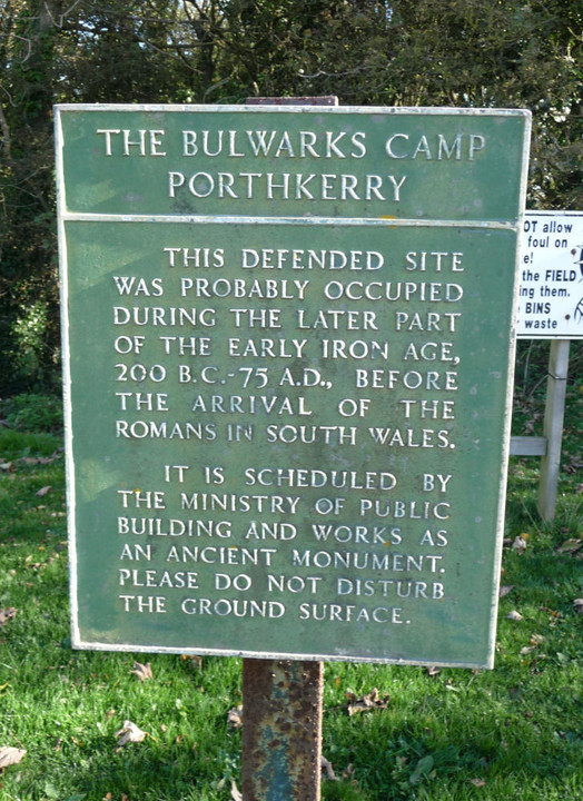
- The Bulwarks, Porthkerry is a promontory fort in Rhoose, Vale of Glamorgan, on the southern coast of Wales overlooking the Bristol Channel.It probably dates to the Iron Age and continued to be occupied during the Roman period in Britain. The ramparts and ditches along the west side are well preserved, but the fortifications are heavily overgrown. (en)
|
| dbo:thumbnail
| |
| dbo:wikiPageExternalLink
| |
| dbo:wikiPageID
| |
| dbo:wikiPageLength
|
- 7949 (xsd:nonNegativeInteger)
|
| dbo:wikiPageRevisionID
| |
| dbo:wikiPageWikiLink
| |
| dbp:alternateName
|
- The Bulwarks, Porthceri (en)
|
| dbp:built
| |
| dbp:caption
|
- Approach lights for Cardiff Airport runway 30 in the north section of the Bulwarks fort (en)
|
| dbp:condition
| |
| dbp:location
|
- Rhoose, Vale of Glamorgan (en)
|
| dbp:mapType
|
- Wales Vale of Glamorgan (en)
|
| dbp:name
|
- The Bulwarks, Porthkerry (en)
|
| dbp:otherDesignation
|
- NPRN 93015; ST 082664 (en)
|
| dbp:publicAccess
| |
| dbp:region
| |
| dbp:relief
| |
| dbp:type
| |
| dbp:wikiPageUsesTemplate
| |
| dcterms:subject
| |
| georss:point
| |
| rdf:type
| |
| rdfs:comment
|
- The Bulwarks, Porthkerry is a promontory fort in Rhoose, Vale of Glamorgan, on the southern coast of Wales overlooking the Bristol Channel.It probably dates to the Iron Age and continued to be occupied during the Roman period in Britain. The ramparts and ditches along the west side are well preserved, but the fortifications are heavily overgrown. (en)
|
| rdfs:label
|
- The Bulwarks, Porthkerry (en)
|
| owl:sameAs
| |
| geo:geometry
|
- POINT(-3.3215138912201 51.388595581055)
|
| geo:lat
| |
| geo:long
| |
| prov:wasDerivedFrom
| |
| foaf:depiction
| |
| foaf:isPrimaryTopicOf
| |
| is dbo:wikiPageWikiLink
of | |
| is foaf:primaryTopic
of | |


