| dbo:PopulatedPlace/areaTotal
| |
| dbo:abstract
|
- Ni'lin (àrab: نعلين, Niʿlīn) és un municipi palestí en la governació de Ramal·lah i al-Bireh, al centre de Cisjordània, situat 17 kilòmetres a l'oest de Ramal·lah. Segons l'Oficina Central d'Estadístiques de Palestina (PCBS), tenia una població de 5.852 habitants en 2016. Ni'lin es troba 3 kilòmetres a l'est de la Línia Verda de 1949, limitat per Deir Qaddis, els assentaments israelians de i al nord-est, la vila d'al-Midya i l'assentament de Modi'in Illit (Kiryat Sefer) al sud, i les viles de Budrus (4 km) i Qibya (5 km) al nord-oest. la superfície municipals és d'uns 15.000 dúnams dels quals 660 són urbans. Per l' el 93.3% de les terres del municipi han estat classificades com a . La majoria dels habitants del municipi es dediquen a l'agricultura, i abans de la Segona Intifada molts treballaven en la construcció a Israel. Està situada a 262 metres sobre el nivell del mar i té hiverns suaus i estius calorosos i secs amb temperatures diürnes de 32 °C (88 °F). (ca)
- نعلين بلدة فلسطينية، تقع في محافظة رام الله والبيرة, وسط الضفة الغربية. (ar)
- Ni'lin (arabisch نعلين) ist ein palästinensisches Dorf mit etwa 4.700 Einwohnern, das zu Ramallah und Al-Bireh in der zentralen Westbank gehört. (de)
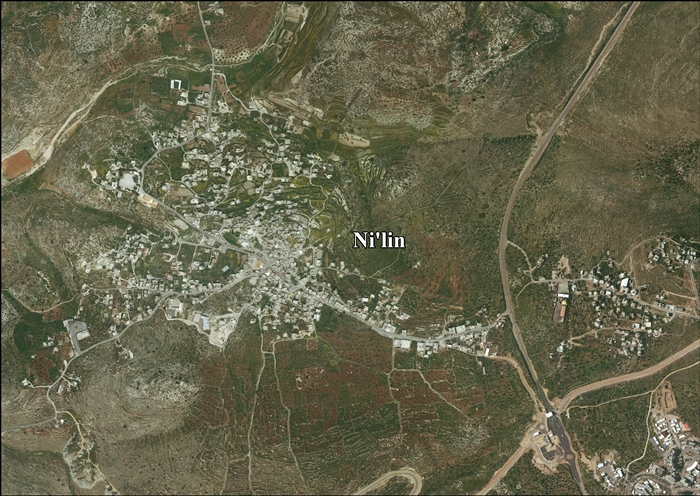
- Ni'lin (Arabic: نعلين) is a Palestinian town in the Ramallah and al-Bireh Governorate in the central West Bank, located 17 kilometers (11 mi) west of Ramallah. Ni'lin is about 3 kilometers (1.9 mi) east of the 1949 Armistice Line (Green Line) bordered by Deir Qaddis, the Israeli settlements of Nili and Na'ale to the northeast, the village of al-Midya and Modi'in Illit (Kiryat Sefer) settlement bloc are to the south, Budrus (4 km) and Qibya (5 km) villages are located to the northwest. The town's total land area consists of approximately 15,000 dunams of which 660 is urban. Under the Oslo II agreement, 93% of town lands has been classed as 'Area C'. Most of the town's inhabitants rely on agriculture for income and prior to the outbreak of the Second Intifada, many had jobs in construction in Israel. According to the Palestinian Central Bureau of Statistics, the town had a population of approximately 4,750 inhabitants in mid-year 2006. Situated 262 meters (860 feet) above sea level, Ni'lin has mild winters and hot, dry summers with temperatures averaging 32 °C (88 °F) during the day. (en)
- Ni'lin (bahasa Arab: نعلين) adalah sebuah kota Palestina di di tengah Tepi Barat, berjarak 17 kilometer (11 mi) dari barat Ramallah. Ni'lin berjarak sekitar 3 kilometer (1,9 mi) dari timur Garis Gencatan Senjata tahun 1949 (Garis Hijau) yang berbatasan dengan , pemukiman Israel dan di timur laut, desa dand blok pemukiman Modi'in Illit (Kiryat Sefer) di selatan, desa (4 km) dan (5 km) yang terletak di barat laut. (in)
- Nilin (arab. نعلين, Niʿlīn) – miasto w Palestynie, w muhafazie Ramallah i Al-Bira. Według danych szacunkowych Palestyńskiego Centralnego Biura Statystycznego w 2016 roku miejscowość liczyła 5852 mieszkańców. Mieszkańcy Nilin i działacze międzynarodowi często organizują demonstracje przeciwko ekspansji bariery izraelskiego Zachodniego Brzegu. (pl)
- Наалин (араб. نعلين) (англ. Nilin, Na'alin) — деревня в Палестинской автономии (Западный берег реки Иордан). Население 3500 жителей, площадь — 7,7 квадратного километра. Расположена в трёх километрах к востоку от зелёной линии. (ru)
|
| dbo:areaTotal
|
- 14800000.000000 (xsd:double)
|
| dbo:country
| |
| dbo:governmentType
| |
| dbo:politicalLeader
| |
| dbo:populationTotal
|
- 4573 (xsd:nonNegativeInteger)
|
| dbo:subdivision
| |
| dbo:thumbnail
| |
| dbo:wikiPageExternalLink
| |
| dbo:wikiPageID
| |
| dbo:wikiPageLength
|
- 30388 (xsd:nonNegativeInteger)
|
| dbo:wikiPageRevisionID
| |
| dbo:wikiPageWikiLink
| |
| dbp:areaTotalDunam
| |
| dbp:areaTotalKm
| |
| dbp:blankInfoSec
|
- N'alin, from na'l, a sandal (en)
|
| dbp:blankNameSec
| |
| dbp:date
| |
| dbp:establishedTitle
| |
| dbp:governmentType
| |
| dbp:gridName
| |
| dbp:gridPosition
| |
| dbp:imageSkyline
| |
| dbp:leaderName
| |
| dbp:leaderTitle
|
- Head of Municipality (en)
|
| dbp:name
| |
| dbp:populationAsOf
| |
| dbp:populationDensityKm
| |
| dbp:populationTotal
| |
| dbp:pushpinMap
| |
| dbp:pushpinMapCaption
|
- Location of Ni'lin within Palestine (en)
|
| dbp:reason
| |
| dbp:subdivisionName
| |
| dbp:subdivisionType
| |
| dbp:translitLang
| |
| dbp:translitLang1Info
| |
| dbp:translitLang1Type
| |
| dbp:type
| |
| dbp:unitPref
| |
| dbp:updated
| |
| dbp:wikiPageUsesTemplate
| |
| dcterms:subject
| |
| gold:hypernym
| |
| georss:point
|
- 31.946666666666665 35.02166666666667
|
| rdf:type
| |
| rdfs:comment
|
- نعلين بلدة فلسطينية، تقع في محافظة رام الله والبيرة, وسط الضفة الغربية. (ar)
- Ni'lin (arabisch نعلين) ist ein palästinensisches Dorf mit etwa 4.700 Einwohnern, das zu Ramallah und Al-Bireh in der zentralen Westbank gehört. (de)
- Ni'lin (bahasa Arab: نعلين) adalah sebuah kota Palestina di di tengah Tepi Barat, berjarak 17 kilometer (11 mi) dari barat Ramallah. Ni'lin berjarak sekitar 3 kilometer (1,9 mi) dari timur Garis Gencatan Senjata tahun 1949 (Garis Hijau) yang berbatasan dengan , pemukiman Israel dan di timur laut, desa dand blok pemukiman Modi'in Illit (Kiryat Sefer) di selatan, desa (4 km) dan (5 km) yang terletak di barat laut. (in)
- Nilin (arab. نعلين, Niʿlīn) – miasto w Palestynie, w muhafazie Ramallah i Al-Bira. Według danych szacunkowych Palestyńskiego Centralnego Biura Statystycznego w 2016 roku miejscowość liczyła 5852 mieszkańców. Mieszkańcy Nilin i działacze międzynarodowi często organizują demonstracje przeciwko ekspansji bariery izraelskiego Zachodniego Brzegu. (pl)
- Наалин (араб. نعلين) (англ. Nilin, Na'alin) — деревня в Палестинской автономии (Западный берег реки Иордан). Население 3500 жителей, площадь — 7,7 квадратного километра. Расположена в трёх километрах к востоку от зелёной линии. (ru)
- Ni'lin (àrab: نعلين, Niʿlīn) és un municipi palestí en la governació de Ramal·lah i al-Bireh, al centre de Cisjordània, situat 17 kilòmetres a l'oest de Ramal·lah. Segons l'Oficina Central d'Estadístiques de Palestina (PCBS), tenia una població de 5.852 habitants en 2016. Ni'lin es troba 3 kilòmetres a l'est de la Línia Verda de 1949, limitat per Deir Qaddis, els assentaments israelians de i al nord-est, la vila d'al-Midya i l'assentament de Modi'in Illit (Kiryat Sefer) al sud, i les viles de Budrus (4 km) i Qibya (5 km) al nord-oest. la superfície municipals és d'uns 15.000 dúnams dels quals 660 són urbans. Per l' el 93.3% de les terres del municipi han estat classificades com a . (ca)
- Ni'lin (Arabic: نعلين) is a Palestinian town in the Ramallah and al-Bireh Governorate in the central West Bank, located 17 kilometers (11 mi) west of Ramallah. Ni'lin is about 3 kilometers (1.9 mi) east of the 1949 Armistice Line (Green Line) bordered by Deir Qaddis, the Israeli settlements of Nili and Na'ale to the northeast, the village of al-Midya and Modi'in Illit (Kiryat Sefer) settlement bloc are to the south, Budrus (4 km) and Qibya (5 km) villages are located to the northwest. The town's total land area consists of approximately 15,000 dunams of which 660 is urban. Under the Oslo II agreement, 93% of town lands has been classed as 'Area C'. (en)
|
| rdfs:label
|
- نعلين (ar)
- Ni'lin (ca)
- Ni'lin (de)
- Ni'lin (in)
- Ni'lin (en)
- Nilin (pl)
- Наалин (ru)
|
| owl:sameAs
| |
| geo:geometry
|
- POINT(35.021667480469 31.946666717529)
|
| geo:lat
| |
| geo:long
| |
| prov:wasDerivedFrom
| |
| foaf:depiction
| |
| foaf:isPrimaryTopicOf
| |
| foaf:name
| |
| is dbo:wikiPageRedirects
of | |
| is dbo:wikiPageWikiLink
of | |
| is foaf:primaryTopic
of | |


