| dbo:PopulatedPlace/areaTotal
| |
| dbo:abstract
|
- خربة زنوتة قرية فلسطينية تقع في محافظة الخليل جنوب الضفة الغربية، وتقع على بعد 20 كم جنوب مدينة الخليل. وتشمل المناطق القريبة الضاحية إلى الشمال الغربي و إلى الشمال الغربي، بالإضافة إلى مستوطنتين إسرائيليتين هما تنيه عمرم من الغرب وشمعة من الشرق. تم بناء المنطقة الصناعية الواقعة إلى الشرق للمستوطنين. القرية مجاورة للخط الأخضر. (ar)
- Khirbet Zanuta o Zanuta —en àrab خربة زنوتا, Ḫirbat Zanūtā— és una vila palestina de la governació d'Hebron, a Cisjordània, situada 20 kilòmetres al nord-oest d'Hebron. Limita amb ad-Dhahiriya i Khirbet Shweika al nord-oest i amb els assentaments israelians de a l'oest i a l'est. La zona industrial de Meitarim just a l'est va ser construïda pels colons. La vila és adjacent a la Línia verda. Segons l'Oficina Central Palestina d'Estadístiques tenia una població de 6 habitants en 1997 que augmentaren a 60 habitants en 2007 i 130 habitants el 2013. Les principals famílies residents són els as-Samamera, al-Tel, al-Batat i al-Qaysiyah. En 2012 el nombre de famílies registrades a Zanuta era de 27. No hi ha escoles, centres d'atenció mèdica o farmàcies a Khirbet Zanuta i els residents recorren 10 quilòmetres fins Ad-Dhahiriya per obtenir aquests serveis. L'agricultura és la principal activitat econòmica, que empra la majoria dels residents treballadors del poble. L'àrea total de la terra és d'aproximadament 12,000 dúnams, dels quals aproximadament 3.000 es conreen. Gran part de l'àrea de la terra restant es consideren «espais oberts», mentre que un dúnam és classificat com a sòl urbà. Les autoritats israelianes estan pressionant als residents perquè se'n vagin. (ca)
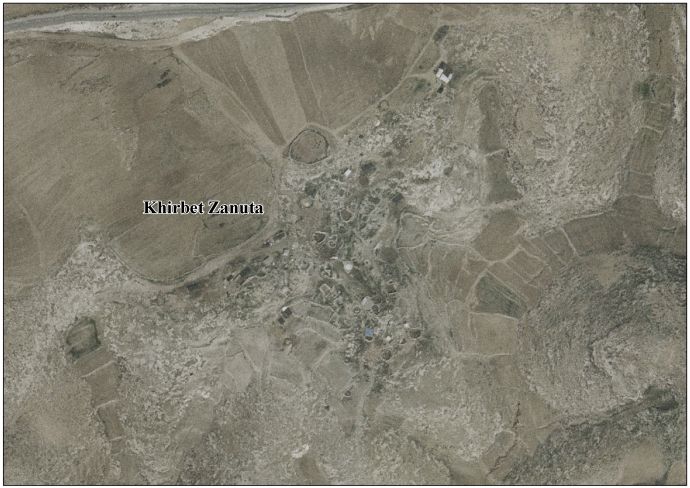
- Khirbet Zanuta (Arabic: خربة زنوتا) is a Palestinian village in the Hebron Governorate in the southern West Bank, located 20 kilometers south of Hebron. Nearby localities include ad-Dhahiriya to the northwest and Khirbet Shweika to the northwest, as well as two Israeli settlements, Teneh Omarim to the west and Shim'a to the east. The Meitarim industrial zone just to its east was built for the settlers. The village is adjacent to the Green Line. According to the Palestinian Central Bureau of Statistics (PCBS), Khirbet Zanuta had a population of 60 in the 2007 census. By 2013 it had 130 residents, a large increase from 1997 when six residents were recorded. The four principal families are the as-Samamera, al-Tel, al-Batat and al-Qaysiyah. In 2012 the number of families registered at Zanuta was 27. There are no schools, health care facilities or pharmacies in Khirbet Zanuta and residents travel 10 kilometers to ad-Dhahiriya to obtain those services. Agriculture is the main economic activity, employing most of the village's working residents. The total land area is approximately 12,000 dunams, of which roughly 3,000 are cultivated, mostly with field crops. Much of the remaining land area is considered "open spaces," while one dunam is classified as built-up areas. Israeli authorities are pressing the residents to leave. (en)
|
| dbo:areaTotal
|
- 12000000.000000 (xsd:double)
|
| dbo:country
| |
| dbo:governmentType
| |
| dbo:populationTotal
|
- 60 (xsd:nonNegativeInteger)
|
| dbo:subdivision
| |
| dbo:wikiPageExternalLink
| |
| dbo:wikiPageID
| |
| dbo:wikiPageLength
|
- 16977 (xsd:nonNegativeInteger)
|
| dbo:wikiPageRevisionID
| |
| dbo:wikiPageWikiLink
| |
| dbp:areaTotalDunam
| |
| dbp:areaTotalKm
| |
| dbp:blankInfoSec
|
- "The ruin of Zanuta" (en)
|
| dbp:blankNameSec
| |
| dbp:establishedTitle
| |
| dbp:governmentType
| |
| dbp:gridName
| |
| dbp:gridPosition
| |
| dbp:name
| |
| dbp:populationAsOf
| |
| dbp:populationDensityKm
| |
| dbp:populationTotal
| |
| dbp:pushpinMap
| |
| dbp:pushpinMapCaption
|
- Location of Khirbet Zanuta within Palestine (en)
|
| dbp:subdivisionName
| |
| dbp:subdivisionType
| |
| dbp:translitLang
| |
| dbp:translitLang1Info
|
- Zanuta (en)
- خربة زنوتا (en)
|
| dbp:translitLang1Type
| |
| dbp:type
| |
| dbp:unitPref
| |
| dbp:wikiPageUsesTemplate
| |
| dcterms:subject
| |
| gold:hypernym
| |
| georss:point
|
- 31.3725 35.005833333333335
|
| rdf:type
| |
| rdfs:comment
|
- خربة زنوتة قرية فلسطينية تقع في محافظة الخليل جنوب الضفة الغربية، وتقع على بعد 20 كم جنوب مدينة الخليل. وتشمل المناطق القريبة الضاحية إلى الشمال الغربي و إلى الشمال الغربي، بالإضافة إلى مستوطنتين إسرائيليتين هما تنيه عمرم من الغرب وشمعة من الشرق. تم بناء المنطقة الصناعية الواقعة إلى الشرق للمستوطنين. القرية مجاورة للخط الأخضر. (ar)
- Khirbet Zanuta o Zanuta —en àrab خربة زنوتا, Ḫirbat Zanūtā— és una vila palestina de la governació d'Hebron, a Cisjordània, situada 20 kilòmetres al nord-oest d'Hebron. Limita amb ad-Dhahiriya i Khirbet Shweika al nord-oest i amb els assentaments israelians de a l'oest i a l'est. La zona industrial de Meitarim just a l'est va ser construïda pels colons. La vila és adjacent a la Línia verda. Segons l'Oficina Central Palestina d'Estadístiques tenia una població de 6 habitants en 1997 que augmentaren a 60 habitants en 2007 i 130 habitants el 2013. Les principals famílies residents són els as-Samamera, al-Tel, al-Batat i al-Qaysiyah. En 2012 el nombre de famílies registrades a Zanuta era de 27. (ca)
- Khirbet Zanuta (Arabic: خربة زنوتا) is a Palestinian village in the Hebron Governorate in the southern West Bank, located 20 kilometers south of Hebron. Nearby localities include ad-Dhahiriya to the northwest and Khirbet Shweika to the northwest, as well as two Israeli settlements, Teneh Omarim to the west and Shim'a to the east. The Meitarim industrial zone just to its east was built for the settlers. The village is adjacent to the Green Line. (en)
|
| rdfs:label
|
- خربة زنوتة (ar)
- Khirbet Zanuta (ca)
- Khirbet Zanuta (en)
|
| owl:sameAs
| |
| geo:geometry
|
- POINT(35.005832672119 31.372499465942)
|
| geo:lat
| |
| geo:long
| |
| prov:wasDerivedFrom
| |
| foaf:isPrimaryTopicOf
| |
| foaf:name
| |
| is dbo:wikiPageRedirects
of | |
| is dbo:wikiPageWikiLink
of | |
| is foaf:primaryTopic
of | |


