| dbo:abstract
|
- Der Ferrocarril Chihuahua al Pacífico (abgekürzt ChP, daher häufig Chepe genannt) ist eine Eisenbahnstrecke sowie eine ehemalige Eisenbahngesellschaft in Mexiko. Die Strecke ist eingleisig, nicht elektrifiziert und gilt als eine der spektakulärsten Eisenbahnstrecken der Welt. (de)
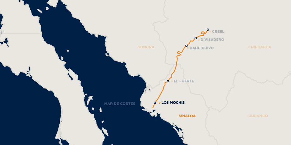
- El Ferrocarril Chihuahua-Pacífico, también conocido como Chepe, es una importante línea ferroviaria mexicana que opera en el noroeste de México; enlaza las ciudades de Chihuahua en el estado de Chihuahua y Los Mochis, en el estado de Sinaloa, en la costa del Océano Pacífico. Recorre 673 km, atravesando las Barrancas del Cobre, una serie de cañones escarpados que han llevado a algunos a llamarlo el viaje en tren más panorámico del continente. Es a la vez un sistema de transporte importante para los lugareños y un atractivo para los turistas de países extranjeros. Las vías pasan por 37 puentes y 86 túneles, elevándose hasta 2400 m sobre el nivel del mar cerca de Divisadero (Divisoria continental de Américal), un mirador popular sobre los cañones. Cada viaje de ida dura aproximadamente 16 horas. La pista también se cruza sobre sí misma para ganar altura. Las sedes a su vez estaban ubicadas en la Ciudad de México, Chihuahua, Chihuahua y Los Mochis, Sinaloa. (es)
- The Ferrocarril Chihuahua al Pacífico (Chihuahua-Pacific Railway), also known as El Chepe from its reporting mark CHP, is a major rail line in northwest Mexico, linking Chihuahua City, to Los Mochis and its port, Topolobampo. It crosses the Sierra Madre Occidental, part of the range that in the United States is called the Rocky Mountains. There is no road covering the trajectory. It runs 673 km (418 mi), traversing the Copper Canyon, a rugged series of canyons that have led some to call this the most scenic railroad trip on the continent. It is both an important transportation system for locals and a draw for tourists. The tracks pass over 37 bridges and through 86 tunnels, rising as high as 2,400 m (7,900 ft) above sea level near Divisadero (the continental divide), a popular lookout spot over the canyons. Each one-way trip takes roughly 16 hours. The track also crosses over itself to gain elevation. The headquarters were in turn located in Mexico City, Chihuahua and Los Mochis. (en)
- Ferrocarril Chihuahua al Pacífico, Pazifikorako Chihuahua Burdinbidea edo Chepeko Trena, Mexikoko ipar-mendebaldeko burdinbide linea garrantzitsu bat da. Barnealdeko Chihuahua estatuko izen berdineko hiria eta Ozeano Barearen kostaldeko Sinaloa estatuko Los Mochis hiria elkarlotzen ditu. Bertako bidaiariez gain, turistek ere maiz erabiltzen duten garraiobidea da. Denera 673 kilometroko ibilbidea egiten du, tartean Barrancas del Cobre arroila zeharkatuz. (eu)
- Le chemin de fer Chihuahua-Pacifique, plutôt connu sous le pseudonyme d'El Chepe, est une importante ligne ferroviaire du nord-ouest du Mexique qui relie les villes de Chihuahua (état du même nom) et de Los Mochis (état de Sinaloa) sur la côte Pacifique. La ligne, exploitée par Ferromex, est classée comme l'une des treize merveilles du Mexique créées par l'homme. Elle traverse la chaîne de montagnes de la Sierra Madre occidentale et longe les Barrancas del Cobre (Canyons de Cuivre). La ligne accueille des trains touristiques, locaux et touristiques sous le nom de El Chepe, mais également des trains de fret, car la ligne est la seule voie de communication terrestre dans cette région. L'abréviation "CHEPE" provient du reporting mark CHP (pour Chihuahua et Pacifique), prononcées en espagnol. (fr)
- チワワ太平洋鉄道(チワワたいへいようてつどう、Ferrocarril Chihuahua al Pacífico, ChP, Chepe チェペ)は、メキシコ北西部の主要鉄道である。 (ja)
- 치와와 태평양 철도(Ferrocarril Chihuahua al Pacífico)는 멕시코 서부 시날로아주 로스모치스와 토폴로밤포에서부터 구리 협곡을 지나 치와와 시를 연결하는 열차 노선이다. 엘체페(El Chepe)라고도 불린다. 총 37개의 다리와 86개의 터널을 통과하며, 디비사데로 역 인근에서는 해발 2400미터까지 오른다. 1880년 공식적으로 구상되었으며, 1900년 경에 공사가 시작되었지만, 1961년에야 완성되었다. 1998년 페로멕스가 멕시코 정부로부터 인수하였다. (ko)
- De Ferrocarril Chihuahua al Pacifico, ook bekend als CHEPE, is een bekende spoorweglijn in Mexico. Hij verbindt Chihuahua met Los Mochis, aan de Grote Oceaan. De spoorlijn heeft een lengte van 653 kilometer. Op het traject bevinden zich 37 bruggen en 87 tunnels. Het hoogste punt ligt 2424 meter boven zeeniveau. Een deel van de spoorlijn loopt langs de Koperkloof (Barranca del Cobre), het diepste canyonsysteem ter wereld. De trein stopt gedurende 15 minuten bij het station El Divisadero, een van de meest adembenemende delen van de Koperkloof. De eerste aanzet van de bouw van de Chihuahua al Pacifíco was in 1880 toen president Manuel González een spoorwegconcessie gaf aan de utopisch socialist , die in Los Mochis een utopische kolonie wilde vestigen. Door financiële tegenvallers, een onrustig politiek klimaat en het lastige terrein duurde het tot 1961 voor de spoorlijn gereed was. Na de privatisering van de spoorwegen in 1998 kwam de Chihuahua al Pacífico in handen van . Sinds 2019 rijden er twee soorten treinen, de Chepe Express en de Chepe Regional, elk met een eigen schema van 3 dagen per week. Met de Chepe Express mogen zonder extra kosten twee tussenstops worden gemaakt. Met de Chepe Regional zijn dat er drie. Dit schema houdt in dat 3 tussenstops met de Regional een week duurt. (nl)
- La Ferrocarril Chihuahua al Pacífico, nota anche come El Chepe, con l'abbreviazione di CHP, o Ferrocarril Chihuahua-Pacífico, è una importante linea ferroviaria del nord-ovest del Messico, che collega la città di Chihuahua, nell'omonimo stato, con quella di Los Mochis, nello stato di Sinaloa, e il porto di Topolobampo. (it)
- Ferrocarril Chihuahua al Pacífico (El Chepe) är ett tidigare järnvägsbolag och en 653 kilometer lång normalspårig järnvägslinje mellan staden Chihuahua i delstaten Chihuahua i norra Mexiko och staden Los Mochis vid Stilla havet i delstaten Sinaloa. Järnvägen passerar Barranca del Cobre, en grupp av raviner i fjällkedjan Sierra Madre Occidental, och anses som en av världens vackraste järnvägslinjer. Järnvägen började byggas i slutet av 1800-talet då amerikanen Albert Kimsey Owen ville bygga en socialistisk mönsterstad vid stillahavskusten och förbinda den med en tåglinje till Kansas City i USA. Mönsterstaden byggdes aldrig och järnvägen, som byggdes mellan Chihuahua och Los Mochis, blev klar först 1961. Den går över 37 broar och genom 86 tunnlar. Den högsta stationen på linjen är Creel, som ligger 2 400 meter över havet. Resan tar mellan 9 och 16 timmar. Det ordinarie tåget Chepe Regional stannar på 13 stationer och används främst av lokalbefolkningen. Chepe Express, som invigdes i maj 2018, går endast från Los Mochis till Creel och stannar på tre stationer. (sv)
- Железная дорога Чиуауа — Тихий океан (исп. Ferrocarril Chihuahua al Pacífico), так же известна как Эль-Чепе (исп. El Chepe — акроним Chihuahua al Pacífico) — однопутная 688-километровая железнодорожная линия в Северной Мексике, которая связывает между собой столицу штата Чиуауа город Чиуауа с тихоокеанским по́ртом Тополобампо в штате Синалоа. Пересекает Медный Каньон и главный хребет Сьерры-Мадре Западной, притягивая туристов со всей Мексики и даже иностранцев. (ru)
|
| rdfs:comment
|
- Der Ferrocarril Chihuahua al Pacífico (abgekürzt ChP, daher häufig Chepe genannt) ist eine Eisenbahnstrecke sowie eine ehemalige Eisenbahngesellschaft in Mexiko. Die Strecke ist eingleisig, nicht elektrifiziert und gilt als eine der spektakulärsten Eisenbahnstrecken der Welt. (de)
- Ferrocarril Chihuahua al Pacífico, Pazifikorako Chihuahua Burdinbidea edo Chepeko Trena, Mexikoko ipar-mendebaldeko burdinbide linea garrantzitsu bat da. Barnealdeko Chihuahua estatuko izen berdineko hiria eta Ozeano Barearen kostaldeko Sinaloa estatuko Los Mochis hiria elkarlotzen ditu. Bertako bidaiariez gain, turistek ere maiz erabiltzen duten garraiobidea da. Denera 673 kilometroko ibilbidea egiten du, tartean Barrancas del Cobre arroila zeharkatuz. (eu)
- チワワ太平洋鉄道(チワワたいへいようてつどう、Ferrocarril Chihuahua al Pacífico, ChP, Chepe チェペ)は、メキシコ北西部の主要鉄道である。 (ja)
- 치와와 태평양 철도(Ferrocarril Chihuahua al Pacífico)는 멕시코 서부 시날로아주 로스모치스와 토폴로밤포에서부터 구리 협곡을 지나 치와와 시를 연결하는 열차 노선이다. 엘체페(El Chepe)라고도 불린다. 총 37개의 다리와 86개의 터널을 통과하며, 디비사데로 역 인근에서는 해발 2400미터까지 오른다. 1880년 공식적으로 구상되었으며, 1900년 경에 공사가 시작되었지만, 1961년에야 완성되었다. 1998년 페로멕스가 멕시코 정부로부터 인수하였다. (ko)
- La Ferrocarril Chihuahua al Pacífico, nota anche come El Chepe, con l'abbreviazione di CHP, o Ferrocarril Chihuahua-Pacífico, è una importante linea ferroviaria del nord-ovest del Messico, che collega la città di Chihuahua, nell'omonimo stato, con quella di Los Mochis, nello stato di Sinaloa, e il porto di Topolobampo. (it)
- Железная дорога Чиуауа — Тихий океан (исп. Ferrocarril Chihuahua al Pacífico), так же известна как Эль-Чепе (исп. El Chepe — акроним Chihuahua al Pacífico) — однопутная 688-километровая железнодорожная линия в Северной Мексике, которая связывает между собой столицу штата Чиуауа город Чиуауа с тихоокеанским по́ртом Тополобампо в штате Синалоа. Пересекает Медный Каньон и главный хребет Сьерры-Мадре Западной, притягивая туристов со всей Мексики и даже иностранцев. (ru)
- The Ferrocarril Chihuahua al Pacífico (Chihuahua-Pacific Railway), also known as El Chepe from its reporting mark CHP, is a major rail line in northwest Mexico, linking Chihuahua City, to Los Mochis and its port, Topolobampo. It crosses the Sierra Madre Occidental, part of the range that in the United States is called the Rocky Mountains. There is no road covering the trajectory. The headquarters were in turn located in Mexico City, Chihuahua and Los Mochis. (en)
- El Ferrocarril Chihuahua-Pacífico, también conocido como Chepe, es una importante línea ferroviaria mexicana que opera en el noroeste de México; enlaza las ciudades de Chihuahua en el estado de Chihuahua y Los Mochis, en el estado de Sinaloa, en la costa del Océano Pacífico. Recorre 673 km, atravesando las Barrancas del Cobre, una serie de cañones escarpados que han llevado a algunos a llamarlo el viaje en tren más panorámico del continente. Es a la vez un sistema de transporte importante para los lugareños y un atractivo para los turistas de países extranjeros. (es)
- Le chemin de fer Chihuahua-Pacifique, plutôt connu sous le pseudonyme d'El Chepe, est une importante ligne ferroviaire du nord-ouest du Mexique qui relie les villes de Chihuahua (état du même nom) et de Los Mochis (état de Sinaloa) sur la côte Pacifique. La ligne, exploitée par Ferromex, est classée comme l'une des treize merveilles du Mexique créées par l'homme. Elle traverse la chaîne de montagnes de la Sierra Madre occidentale et longe les Barrancas del Cobre (Canyons de Cuivre). L'abréviation "CHEPE" provient du reporting mark CHP (pour Chihuahua et Pacifique), prononcées en espagnol. (fr)
- De Ferrocarril Chihuahua al Pacifico, ook bekend als CHEPE, is een bekende spoorweglijn in Mexico. Hij verbindt Chihuahua met Los Mochis, aan de Grote Oceaan. De spoorlijn heeft een lengte van 653 kilometer. Op het traject bevinden zich 37 bruggen en 87 tunnels. Het hoogste punt ligt 2424 meter boven zeeniveau. Een deel van de spoorlijn loopt langs de Koperkloof (Barranca del Cobre), het diepste canyonsysteem ter wereld. De trein stopt gedurende 15 minuten bij het station El Divisadero, een van de meest adembenemende delen van de Koperkloof. (nl)
- Ferrocarril Chihuahua al Pacífico (El Chepe) är ett tidigare järnvägsbolag och en 653 kilometer lång normalspårig järnvägslinje mellan staden Chihuahua i delstaten Chihuahua i norra Mexiko och staden Los Mochis vid Stilla havet i delstaten Sinaloa. Järnvägen passerar Barranca del Cobre, en grupp av raviner i fjällkedjan Sierra Madre Occidental, och anses som en av världens vackraste järnvägslinjer. (sv)
|


.jpg)
.jpg)