| dbo:PopulatedPlace/areaTotal
| |
| dbo:abstract
|
- Beitin (àrab: بيتين, Baytīn) és una vila palestina en la governació de Ramal·lah i al-Bireh, al centre de Cisjordània, situada 5 kilòmetres al nord-est de Ramal·lah. Segons l'Oficina Central d'Estadístiques de Palestina (PCBS), tenia una població de 2.742 habitants en 2016. Està situada al llarg de l' i limita amb les viles de Dura al-Qar' i Ein Yabrud al nord, Rammun a l'est, Deir Dibwan al sud-est i al-Bireh al sud-oest. L'assentament israelià de Beit El és al nord-oest de Beitin. (ca)
- بيتَين هي قرية فلسطينية تقع في الضفة الغربية من أراض السلطة الفلسطينية. وتتبع محافظة رام الله والبيرة وقعت تحت الاحتلال الإسرائيلي في حرب 1967. (ar)
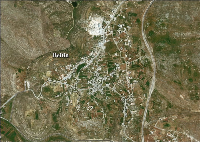
- Beitin (Arabic: بيتين Bitīn) is a Palestinian village in the Ramallah and al-Bireh Governorate in the central West Bank, located 5 kilometers (3.1 mi) northeast of Ramallah along the Ramallah-Nablus road. The Palestinian village of Dura al-Qar' and Ein Yabrud lie to the north, Rammun to the east, Deir Dibwan to the southeast and al-Bireh to the southwest. The Israeli settlement of Beit El is northwest of Beitin. (en)
- Beitin (bahasa Arab: بيتين Bitīn) adalah suatu kota Palestina di Kegubernuran Ramallah dan al-Bireh di Tepi Barat, terletak 5 kilometer (3,1 mi) timur laut Ramallah pada jalur Ramallah-Nablus. Kota-kota Palestina Dura al-Qar' dan Ein Yabrud terletak di sebelah utara, Rammun di timur, Deir Dibwan di tenggara dan al-Bireh di barat daya. Pemukiman Israel "Beit El" terletak di barat laut Beitin. (in)
- Bajtin – wieś w Palestynie, w muhafazie Ramallah i Al-Bira. Według danych Palestyńskiego Centralnego Biura Statystycznego w 2016 roku miejscowość liczyła 2742 mieszkańców. (pl)
|
| dbo:areaTotal
|
- 4800000.000000 (xsd:double)
|
| dbo:country
| |
| dbo:governmentType
| |
| dbo:politicalLeader
| |
| dbo:populationTotal
|
- 2242 (xsd:nonNegativeInteger)
|
| dbo:subdivision
| |
| dbo:thumbnail
| |
| dbo:wikiPageExternalLink
| |
| dbo:wikiPageID
| |
| dbo:wikiPageLength
|
- 30472 (xsd:nonNegativeInteger)
|
| dbo:wikiPageRevisionID
| |
| dbo:wikiPageWikiLink
| |
| dbp:areaTotalDunam
| |
| dbp:areaTotalKm
| |
| dbp:blankInfoSec
|
- corruption of the Hebrew "Bethel", house of God (en)
|
| dbp:blankNameSec
| |
| dbp:establishedDate
| |
| dbp:establishedTitle
| |
| dbp:governmentType
| |
| dbp:gridName
| |
| dbp:gridPosition
| |
| dbp:imageCaption
|
- Beitin, late 19th century, by Felix Bonfils (en)
|
| dbp:imageSkyline
|
- File:COLOR PHOTO FROM THE LATE 19TH CENTURY TAKEN BY FRENCH PHOTOGRAPHER, BONFILS, DEPICTING THE BET EL AREA NEAR JERUSALEM. צילום צבע מסוף המאה ה 19 פרי מצלמתו של הצלם הצרפתי בונפ.jpg (en)
|
| dbp:leaderName
|
- Tawfiq Musa Al-Hajya (en)
|
| dbp:leaderTitle
|
- Head of Municipality (en)
|
| dbp:name
| |
| dbp:populationAsOf
| |
| dbp:populationDensityKm
| |
| dbp:populationTotal
| |
| dbp:pushpinMap
| |
| dbp:pushpinMapCaption
|
- Location of Beitin within Palestine (en)
|
| dbp:subdivisionName
| |
| dbp:subdivisionType
| |
| dbp:translitLang
| |
| dbp:translitLang1Info
|
- Baytin (en)
- Bittin (en)
- بيتين (en)
|
| dbp:translitLang1Type
| |
| dbp:type
| |
| dbp:unitPref
| |
| dbp:wikiPageUsesTemplate
| |
| dcterms:subject
| |
| gold:hypernym
| |
| georss:point
|
- 31.928333333333335 35.23833333333334
|
| rdf:type
| |
| rdfs:comment
|
- Beitin (àrab: بيتين, Baytīn) és una vila palestina en la governació de Ramal·lah i al-Bireh, al centre de Cisjordània, situada 5 kilòmetres al nord-est de Ramal·lah. Segons l'Oficina Central d'Estadístiques de Palestina (PCBS), tenia una població de 2.742 habitants en 2016. Està situada al llarg de l' i limita amb les viles de Dura al-Qar' i Ein Yabrud al nord, Rammun a l'est, Deir Dibwan al sud-est i al-Bireh al sud-oest. L'assentament israelià de Beit El és al nord-oest de Beitin. (ca)
- بيتَين هي قرية فلسطينية تقع في الضفة الغربية من أراض السلطة الفلسطينية. وتتبع محافظة رام الله والبيرة وقعت تحت الاحتلال الإسرائيلي في حرب 1967. (ar)
- Beitin (Arabic: بيتين Bitīn) is a Palestinian village in the Ramallah and al-Bireh Governorate in the central West Bank, located 5 kilometers (3.1 mi) northeast of Ramallah along the Ramallah-Nablus road. The Palestinian village of Dura al-Qar' and Ein Yabrud lie to the north, Rammun to the east, Deir Dibwan to the southeast and al-Bireh to the southwest. The Israeli settlement of Beit El is northwest of Beitin. (en)
- Beitin (bahasa Arab: بيتين Bitīn) adalah suatu kota Palestina di Kegubernuran Ramallah dan al-Bireh di Tepi Barat, terletak 5 kilometer (3,1 mi) timur laut Ramallah pada jalur Ramallah-Nablus. Kota-kota Palestina Dura al-Qar' dan Ein Yabrud terletak di sebelah utara, Rammun di timur, Deir Dibwan di tenggara dan al-Bireh di barat daya. Pemukiman Israel "Beit El" terletak di barat laut Beitin. (in)
- Bajtin – wieś w Palestynie, w muhafazie Ramallah i Al-Bira. Według danych Palestyńskiego Centralnego Biura Statystycznego w 2016 roku miejscowość liczyła 2742 mieszkańców. (pl)
|
| rdfs:label
|
- Beitin (en)
- بيتين (ar)
- Beitin (ca)
- Beitin (Westjordanland) (de)
- Beitin (in)
- Bajtin (pl)
|
| owl:sameAs
| |
| geo:geometry
|
- POINT(35.238334655762 31.928333282471)
|
| geo:lat
| |
| geo:long
| |
| prov:wasDerivedFrom
| |
| foaf:depiction
| |
| foaf:isPrimaryTopicOf
| |
| foaf:name
| |
| is dbo:wikiPageRedirects
of | |
| is dbo:wikiPageWikiLink
of | |
| is foaf:primaryTopic
of | |


