This HTML5 document contains 222 embedded RDF statements represented using HTML+Microdata notation.
The embedded RDF content will be recognized by any processor of HTML5 Microdata.
| Prefix | IRI |
|---|---|
| dbt | http://dbpedia.org/resource/Template: |
| n50 | http://dbpedia.org/ontology/PopulatedPlace/ |
| wikipedia-en | http://en.wikipedia.org/wiki/ |
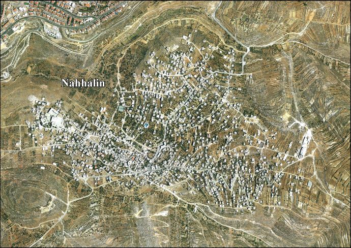
| n5 | http://www.palestineremembered.com/GeoPoints/Nahhalin_1449/ |
| dbr | http://dbpedia.org/resource/ |
| dbpedia-ar | http://ar.dbpedia.org/resource/ |
| geo | http://www.w3.org/2003/01/geo/wgs84_pos# |
| dbpedia-he | http://he.dbpedia.org/resource/ |
| georss | http://www.georss.org/georss/ |
| schema | http://schema.org/ |
| n29 | http://vprofile.arij.org/bethlehem/images/areal/ |
| n45 | http://commons.wikimedia.org/wiki/Special:FilePath/ |
| dbpedia-fr | http://fr.dbpedia.org/resource/ |
| n34 | https://archive.org/details/descriptiongogr06gugoog%7Cvolume=1: |
| n20 | http://web.nli.org.il/sites/nli/Hebrew/library/Pages/ |
| dcterms | http://purl.org/dc/terms/ |
| n23 | https://web.archive.org/web/20140224062612/http:/www.ochaopt.org/documents/ |
| rdfs | http://www.w3.org/2000/01/rdf-schema# |
| n48 | https://www.bbc.com/news/ |
| rdf | http://www.w3.org/1999/02/22-rdf-syntax-ns# |
| n35 | https://web.archive.org/web/20181103051759/http:/www.iaa-archives.org.il/zoom/ |
| n25 | http://dbpedia.org/resource/File: |
| dbp | http://dbpedia.org/property/ |
| n24 | https://www.welcometopalestine.com/destinations/bethlehem/nahalin/ |
| n47 | http://cs.anu.edu.au/~bdm/yabber/census/ |
| xsdh | http://www.w3.org/2001/XMLSchema# |
| dbo | http://dbpedia.org/ontology/ |
| n42 | https://books.google.com/ |
| dbc | http://dbpedia.org/resource/Category: |
| dbpedia-pl | http://pl.dbpedia.org/resource/ |
| yago | http://dbpedia.org/class/yago/ |
| wikidata | http://www.wikidata.org/entity/ |
| gold | http://purl.org/linguistics/gold/ |
| yago-res | http://yago-knowledge.org/resource/ |
| n43 | http://www.poica.org/editor/case_studies/ |
| n36 | https://global.dbpedia.org/id/ |
| n49 | http://www.palestineremembered.com/Articles/General-2/ |
| dbpedia-ca | http://ca.dbpedia.org/resource/ |
| n38 | https://www.un.org/unrwa/emergency/barrier/profiles/ |
| prov | http://www.w3.org/ns/prov# |
| dbpedia-nn | http://nn.dbpedia.org/resource/ |
| foaf | http://xmlns.com/foaf/0.1/ |
| n31 | http://vprofile.arij.org/bethlehem/pdfs/VP/ |
| n33 | http://vprofile.arij.org/bethlehem/pdfs/needsfordevelopment/ |
| n27 | http://arz.dbpedia.org/resource/ |
| n9 | https://archive.org/details/ |
| n41 | http://www.poica.org/ |
| freebase | http://rdf.freebase.com/ns/ |
| dbpedia-es | http://es.dbpedia.org/resource/ |
| n30 | http://vprofile.arij.org/bethlehem/pdfs/EN/ |
| owl | http://www.w3.org/2002/07/owl# |