| dbo:abstract
|
- زرعين تقوم على بقعة (يزراعيل) الكنعانية. وزرعين كلمة سريانية بمعنى (فلاحون ومزارعون) . وتقع إلى الشمال من مدينة جنين ، وتبعد عنها 11كم . وترتفع عن سطح البحر 100متر. تبلغ مساحة أراضيها (23920) دونما يحيط بها قرى نورس والمزار وتعنك . قدر عدد سكانها في عام 1922 (722) نسمة وعام 1945 حوالي (1420) نسمة . قامت المنظمات الصهيونية المسلحة بهدم القرية وتشريد أهلها البالغ عددهم عام 48 (1464) نسمة . وكان ذلك في 28-5-1948 ، وعلى أنقاضها أقام الصهاينة مستعمرة (يزراعيل) عام 1948 . ويبلغ مجموع اللاجئين من هذه القرية في عام 1998 حوالي (10116) نسمة. في عام 1933، أقيمت على أراضي تابعة للقرية مستوطنة «أفيتال». (ar)
- Zir'in (bahasa Arab: زرعين, juga disebut Zerein) adalah sebuah desa Arab Palestina di Lembah Jezreel, yang berjarak 11 kilometer (6,8 mi) dari utara Jenin. Diidentifikasikan sebagai kota kuno , desa terebut dikenal sebagai Zir'in pada masa kekuasaan Islam, dan berada di dekat situs Pertempuran Ain Jalut, dimana Mamluk menghadapi ekspansi Mongol dari wilayah selatan. Di bawah kekuasaan Utsmaniyah, desa tersebut menjadi sebuah desa kecil, diperlebar pada masa Mandat Britania pada awal abad ke-20. Setelah direbut oleh Israel pada 1948, Zir'in dihancurkan. (in)
- Zir'in (Arabic: زرعين, also spelled Zerein) was a Palestinian Arab village of over 1,400 in the Jezreel Valley, located 11 kilometers (6.8 mi) north of Jenin. Identified as the ancient town of Yizre'el (Jezreel), it was known as Zir'in during Islamic rule, and was near the site of the Battle of Ain Jalut, in which the Mamluks halted Mongol expansion southward. Under the Ottomans, it was a small village, expanding during the British Mandate in the early 20th century. After its capture by Israel in 1948, Zir'in was destroyed. The Israeli kibbutz of Yizre'el was established shortly after on the village lands of Zir'in. (en)
- Zirin (arab. زرعين) – nieistniejąca już arabska wieś, która była położona w Dystrykcie Dżaninu w Mandacie Palestyny. Wieś została wyludniona i zniszczona podczas I wojny izraelsko-arabskiej, po ataku Sił Obronnych Izraela w dniu 28 maja 1948. (pl)
|
| dbo:country
| |
| dbo:foundingDate
| |
| dbo:populationTotal
|
- 1420 (xsd:nonNegativeInteger)
|
| dbo:subdivision
| |
| dbo:synonym
| |
| dbo:thumbnail
| |
| dbo:wikiPageExternalLink
| |
| dbo:wikiPageID
| |
| dbo:wikiPageLength
|
- 21273 (xsd:nonNegativeInteger)
|
| dbo:wikiPageRevisionID
| |
| dbo:wikiPageWikiLink
| |
| dbp:areaTotalDunam
| |
| dbp:blank3InfoSec
| |
| dbp:blank3NameSec
| |
| dbp:blankInfoSec
|
- Military assault by Yishuv forces (en)
|
| dbp:blankNameSec
|
- Cause of depopulation (en)
|
| dbp:establishedDate
| |
| dbp:establishedTitle
|
- Date of depopulation (en)
|
| dbp:gridName
| |
| dbp:gridPosition
| |
| dbp:imageCaption
|
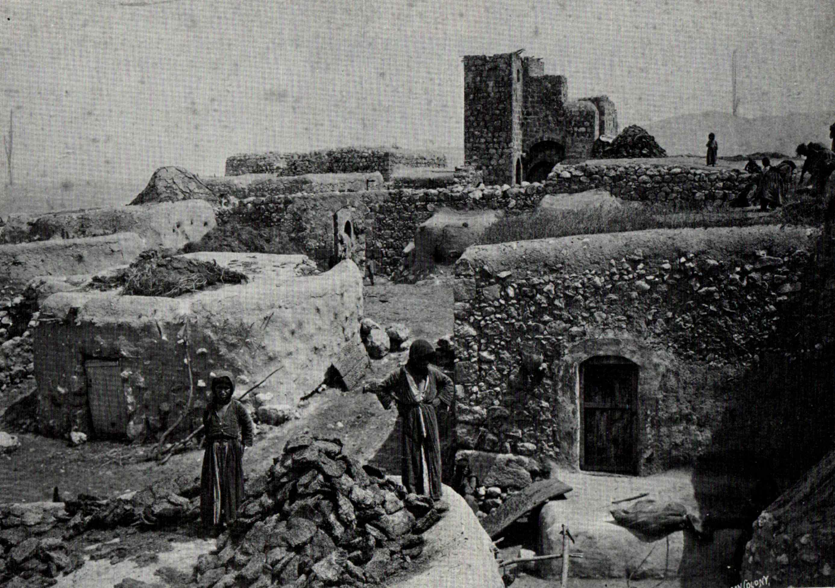
- The Tower House of Zir'in, by Felix Bonfils, before 1885. (en)
|
| dbp:imageSkyline
|
- REMNANTS OF AN ARAB PALACE IN GALILEE. COLOR PHOTO TAKEN IN THE LATE 19TH CENTURY BY FRENCH PHOTOGRAPHER, BONFILS. צילום צבע מסוף המאה ה19 של הצלם הצרפתי בונפיס אשר תעד במצלמת.jpg (en)
|
| dbp:mapCaption
|
- A series of historical maps of the area around Zir'in (en)
|
| dbp:name
| |
| dbp:nativeName
| |
| dbp:nativeNameLang
| |
| dbp:otherName
| |
| dbp:populationAsOf
| |
| dbp:populationTotal
| |
| dbp:pushpinMap
| |
| dbp:pushpinMapCaption
|
- Location within Mandatory Palestine (en)
|
| dbp:pushpinMapsize
| |
| dbp:subdivisionName
| |
| dbp:subdivisionType
| |
| dbp:unitPref
| |
| dbp:wikiPageUsesTemplate
| |
| dcterms:subject
| |
| gold:hypernym
| |
| georss:point
|
- 32.5575 35.327777777777776
|
| rdf:type
| |
| rdfs:comment
|
- زرعين تقوم على بقعة (يزراعيل) الكنعانية. وزرعين كلمة سريانية بمعنى (فلاحون ومزارعون) . وتقع إلى الشمال من مدينة جنين ، وتبعد عنها 11كم . وترتفع عن سطح البحر 100متر. تبلغ مساحة أراضيها (23920) دونما يحيط بها قرى نورس والمزار وتعنك . قدر عدد سكانها في عام 1922 (722) نسمة وعام 1945 حوالي (1420) نسمة . قامت المنظمات الصهيونية المسلحة بهدم القرية وتشريد أهلها البالغ عددهم عام 48 (1464) نسمة . وكان ذلك في 28-5-1948 ، وعلى أنقاضها أقام الصهاينة مستعمرة (يزراعيل) عام 1948 . ويبلغ مجموع اللاجئين من هذه القرية في عام 1998 حوالي (10116) نسمة. في عام 1933، أقيمت على أراضي تابعة للقرية مستوطنة «أفيتال». (ar)
- Zir'in (bahasa Arab: زرعين, juga disebut Zerein) adalah sebuah desa Arab Palestina di Lembah Jezreel, yang berjarak 11 kilometer (6,8 mi) dari utara Jenin. Diidentifikasikan sebagai kota kuno , desa terebut dikenal sebagai Zir'in pada masa kekuasaan Islam, dan berada di dekat situs Pertempuran Ain Jalut, dimana Mamluk menghadapi ekspansi Mongol dari wilayah selatan. Di bawah kekuasaan Utsmaniyah, desa tersebut menjadi sebuah desa kecil, diperlebar pada masa Mandat Britania pada awal abad ke-20. Setelah direbut oleh Israel pada 1948, Zir'in dihancurkan. (in)
- Zir'in (Arabic: زرعين, also spelled Zerein) was a Palestinian Arab village of over 1,400 in the Jezreel Valley, located 11 kilometers (6.8 mi) north of Jenin. Identified as the ancient town of Yizre'el (Jezreel), it was known as Zir'in during Islamic rule, and was near the site of the Battle of Ain Jalut, in which the Mamluks halted Mongol expansion southward. Under the Ottomans, it was a small village, expanding during the British Mandate in the early 20th century. After its capture by Israel in 1948, Zir'in was destroyed. The Israeli kibbutz of Yizre'el was established shortly after on the village lands of Zir'in. (en)
- Zirin (arab. زرعين) – nieistniejąca już arabska wieś, która była położona w Dystrykcie Dżaninu w Mandacie Palestyny. Wieś została wyludniona i zniszczona podczas I wojny izraelsko-arabskiej, po ataku Sił Obronnych Izraela w dniu 28 maja 1948. (pl)
|
| rdfs:label
|
- زرعين (ar)
- Zir'in (in)
- Zirin (pl)
- Zir'in (en)
|
| owl:sameAs
| |
| geo:geometry
|
- POINT(35.327777862549 32.557498931885)
|
| geo:lat
| |
| geo:long
| |
| prov:wasDerivedFrom
| |
| foaf:depiction
| |
| foaf:isPrimaryTopicOf
| |
| foaf:name
| |
| is dbo:wikiPageDisambiguates
of | |
| is dbo:wikiPageRedirects
of | |
| is dbo:wikiPageWikiLink
of | |
| is foaf:primaryTopic
of | |


