| dbo:abstract
|
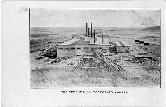
- Yocemento is an unincorporated community in Big Creek Township, Ellis County, Kansas, United States. The settlement lies across the banks of Big Creek against the base of bluffs capped by massive limestone blocks, in which lies the 20th-century origin of the community. The original settler name for the location was Hog Back, with a railway station first established there with that name in 1881. This station was later moved to Hog Back, Kansas. Hog Back was the local name for the high limestone and chalk ridge that runs from just west of old Fort Hays to Ellis. These bluffs are the local outcrop of the Fort Hays Limestone. Founded in 1906 by business partners Erasmus Haworth, the first state geologist of Kansas, and I. M. Yost, leading businessman and miller of Hays, Yocemento is one of the around the outskirts of the High Plains that were founded to use Fort Hays Limestone to manufacture Portland cement. (en)
- 約斯門托(英語:Yocemento)是位於美國堪薩斯州埃利斯縣的一個非建制地區。該地的面積和人口皆未知。 (zh)
|
| dbo:areaCode
| |
| dbo:elevation
| |
| dbo:postalCode
| |
| dbo:subdivision
| |
| dbo:thumbnail
| |
| dbo:timeZone
| |
| dbo:type
| |
| dbo:utcOffset
| |
| dbo:wikiPageExternalLink
| |
| dbo:wikiPageID
| |
| dbo:wikiPageLength
|
- 69711 (xsd:nonNegativeInteger)
|
| dbo:wikiPageRevisionID
| |
| dbo:wikiPageWikiLink
|
- dbr:Carlile_Shale
- dbr:Public_auction
- dbr:Roman_Catholicism
- dbr:Rome,_Ellis_County,_Kansas
- dbr:Midden
- dbc:History_of_Kansas
- dbr:Battle_of_the_Saline_River
- dbr:Big_Creek_(Kansas)
- dbr:Big_Creek_Township,_Ellis_County,_Kansas
- dbr:Bone_Wars
- dbr:Denver
- dbc:Cement_companies_of_the_United_States
- dbc:Woodland_period
- dbr:Anticline
- dbc:Unincorporated_communities_in_Ellis_County,_Kansas
- dbr:Area_code_785
- dbr:Hog_Back,_Kansas
- dbr:Hundredweight
- dbr:Hungarians
- dbr:List_of_counties_in_Kansas
- dbr:List_of_sovereign_states
- dbr:Pawnee_people
- dbr:Republican_River
- dbr:Robert_Benecke
- dbr:Union_Pacific_Railroad
- dbr:University_of_Kansas
- dbr:Victoria,_Kansas
- dbr:Deep_foundation
- dbr:Interstate_Commerce_Commission
- dbr:Level_crossing
- dbr:North_American_Numbering_Plan
- dbr:100th_meridian_west
- dbr:Confederate_States_of_America
- dbc:Geology_of_Kansas
- dbr:Medicine_Lodge_Treaty
- dbr:Salina,_Kansas
- dbr:Saline_River_(Kansas)
- dbr:Chetolah,_Kansas
- dbr:Cheyenne
- dbr:George_Augustus_Armes
- dbr:Outdoor_recreation
- dbr:Ellis,_Kansas
- dbr:Ellis_County,_Kansas
- dbr:Ellsworth,_Kansas
- dbr:Geographic_Names_Information_System
- dbr:Great_Plains
- dbr:Erasmus_Haworth
- dbc:1867_in_Kansas
- dbr:Arapaho
- dbr:Benton_Shale
- dbr:Boettcher_Foundation
- dbr:Smoky_Hill_River
- dbr:Smoky_Hills
- dbc:Landmarks_in_Kansas
- dbr:Comanche
- dbr:Denver_Tramway
- dbr:ZIP_code
- dbr:Dog_Soldier
- dbr:John_Kernan_Mullen
- dbr:Portland,_Fremont_County,_Colorado
- dbr:Portmanteau
- dbr:Buckeye_Township,_Ellis_County,_Kansas
- dbr:Buffalo_Bill
- dbr:Buffalo_Soldier
- dbr:Bunker_Hill,_Kansas
- dbr:Central_Time_Zone
- dbr:U.S._Route_40
- dbr:U.S._state
- dbr:Wallace,_Kansas
- dbr:Wilson,_Kansas
- dbr:Hays_Daily_News
- dbr:Silcrete
- dbr:Alexander_Gardner_(photographer)
- dbr:38th_United_States_Colored_Infantry_Regiment
- dbr:Federal_Information_Processing_Standard
- dbr:Ferdinand_Vandeveer_Hayden
- dbr:Fort_Hays
- dbr:Fort_Hays_Limestone_Member
- dbr:Guide_Rock_(hill)
- dbr:Guillaume_Delisle
- dbr:Hays,_Kansas
- dbr:Interstate_70
- dbr:County_seat
- dbr:Junction_City,_Kansas
- dbr:Kansas
- dbr:Kansas_City,_Missouri
- dbr:Kansas_City_Union_Station
- dbr:Kansas_Department_of_Transportation
- dbr:Kansas_Geological_Survey
- dbr:Kansas_Pacific_Railway
- dbr:Kansas_River
- dbr:Laporte,_Colorado
- dbr:Superior,_Nebraska
- dbr:Trego_County,_Kansas
- dbr:Woodland_period
- dbr:Platte_River
- dbr:Portland_cement
- dbr:Solomon_River
- dbr:Great_American_Desert
- dbr:Gristmill
- dbr:Kiowa
- dbr:Sheridan,_Kansas
- dbr:Yankton,_South_Dakota
- dbr:Santa_Fe_Trail
- dbr:Slump_(geology)
- dbr:Smoky_Hill_City,_Kansas
- dbr:Unincorporated_area
- dbr:Water_stop
- dbr:I._M._Yost
- dbr:File:Union_Station_Kansas_City_6122.JPG
- dbr:List_of_townships_in_Kansas
- dbr:Smoky_Hill_Trail
- dbr:Platted
- dbr:St._Louis,_Missouri
- dbr:Smoky_Hill_Chalk_Member
- dbr:File:SalineRiverAug1867.jpg
- dbr:File:Kansas_official_transportation_map_legend.png
- dbr:File:'Westward_The_Course_of_Empire_Ta...Louis,_Missouri,_October_19,_1867.jpg
- dbr:File:Comanche_1718.jpg
- dbr:File:No._49._Railway_Hotel_at_Ellis,_b...rom_the_Ellis_Quary._(7008415103).jpg
- dbr:File:No._51._The_'Hog_Back'_at_Ellis,_Kansas._(7008429651).jpg
- dbr:File:No._51._The_'Hog_Back'_at_Ellis,_Kansas._(redo_2016).jpg
- dbr:File:No._51._The_'Hog_Back'_at_Ellis,_Kansas_(Sportsmen).png
- dbr:File:No._52._Kansas_Pacific_Railway_Ro...se_at_Ellis,_Kansas._(7008438867).jpg
- dbr:File:On_the_Great_Plains,_Kansas,_294_...ri_River._(Boston_Public_Library).jpg
- dbr:File:Plan_of_Yocemento,_Mill_and_Grounds,_July_1907.png
- dbr:File:The_Cement_Mill,_Yocemento,_Kansa..._before_1917_Scan_04022021_082217.jpg
- dbr:File:The_Cement_Mill,_Yocemento,_Kansas._(SW).jpg
- dbr:File:Yocemento,_quarry_faced_of_Blue_Hill_Shale.jpg
- dbr:File:Yocemento_-_from_the_south_(cropped).jpg
- dbr:File:Yocemento_-_realigned.jpg
- dbr:File:Yocemento_Coop_-_elevator_and_bulk_fertilizer_(cropped).jpg
- dbr:File:Yocemento_and_the_old_Hog_Back_20170213.jpg
- dbr:File:Yocemento_mill_-_remaining_structures_(cropped).jpg
|
| dbp:areaCode
| |
| dbp:areaCodeType
| |
| dbp:blank1Info
| |
| dbp:blank1Name
| |
| dbp:blankInfo
| |
| dbp:blankName
| |
| dbp:elevationFt
| |
| dbp:establishedDate
|
- 1906 (xsd:integer)
- 1907 (xsd:integer)
|
| dbp:establishedTitle
| |
| dbp:imageCaption
|
- Yocemento and the bluffs that gave rise to its brief industry (en)
|
| dbp:imageMap
|
- Map of Ellis Co, Ks, USA.png (en)
|
| dbp:imageSkyline
|
- On the Great Plains, Kansas, 294 miles west of Missouri River. .jpg (en)
|
| dbp:mapCaption
|
- KDOT map of Ellis County (en)
|
| dbp:name
| |
| dbp:populationDensitySqMi
| |
| dbp:postalCode
| |
| dbp:postalCodeType
| |
| dbp:pushpinLabel
| |
| dbp:pushpinLabelPosition
| |
| dbp:pushpinMap
| |
| dbp:settlementType
| |
| dbp:subdivisionName
| |
| dbp:subdivisionType
| |
| dbp:timezone
| |
| dbp:timezoneDst
| |
| dbp:unitPref
| |
| dbp:utcOffset
| |
| dbp:utcOffsetDst
| |
| dbp:wikiPageUsesTemplate
| |
| dcterms:subject
| |
| gold:hypernym
| |
| georss:point
|
- 38.907222222222224 -99.42388888888888
|
| rdf:type
| |
| rdfs:comment
|
- 約斯門托(英語:Yocemento)是位於美國堪薩斯州埃利斯縣的一個非建制地區。該地的面積和人口皆未知。 (zh)
- Yocemento is an unincorporated community in Big Creek Township, Ellis County, Kansas, United States. The settlement lies across the banks of Big Creek against the base of bluffs capped by massive limestone blocks, in which lies the 20th-century origin of the community. (en)
|
| rdfs:label
|
- Yocemento, Kansas (en)
- 約斯門托 (堪薩斯州) (zh)
|
| rdfs:seeAlso
| |
| owl:sameAs
| |
| geo:geometry
|
- POINT(-99.423889160156 38.907222747803)
|
| geo:lat
| |
| geo:long
| |
| prov:wasDerivedFrom
| |
| foaf:depiction
|
- wiki-commons:Special:FilePath/No._51._The_'Hog_Back'_at_Ellis,_Kansas._(7008429651).jpg
- wiki-commons:Special:FilePath/On_the_Great_Plains,_...ri_River._(Boston_Public_Library).jpg
- wiki-commons:Special:FilePath/On_the_Great_Plains,_...st_of_Missouri_River._(redo_2016).jpg
- wiki-commons:Special:FilePath/Kansas_official_transportation_map_legend.png
- wiki-commons:Special:FilePath/Map_of_Ellis_Co,_Ks,_USA.png
- wiki-commons:Special:FilePath/No._49._Railway_Hotel...rom_the_Ellis_Quary._(7008415103).jpg
- wiki-commons:Special:FilePath/No._51._The_'Hog_Back'_at_Ellis,_Kansas._(redo_2016).jpg
- wiki-commons:Special:FilePath/No._51._The_'Hog_Back'_at_Ellis,_Kansas_(Sportsmen).png
- wiki-commons:Special:FilePath/No._52._Kansas_Pacifi...se_at_Ellis,_Kansas._(7008438867).jpg
- wiki-commons:Special:FilePath/Plan_of_Yocemento,_Mill_and_Grounds,_July_1907.png
- wiki-commons:Special:FilePath/The_Cement_Mill,_Yoce..._before_1917_Scan_04022021_082217.jpg
- wiki-commons:Special:FilePath/The_Cement_Mill,_Yocemento,_Kansas._(SW).jpg
- wiki-commons:Special:FilePath/Union_Station_Kansas_City_6122.jpg
- wiki-commons:Special:FilePath/Yocemento,_quarry_faced_of_Blue_Hill_Shale.jpg
- wiki-commons:Special:FilePath/Yocemento_-_from_the_south_(cropped).jpg
- wiki-commons:Special:FilePath/Yocemento_-_realigned.jpg
- wiki-commons:Special:FilePath/Yocemento_Coop_-_elevator_and_bulk_fertilizer_(cropped).jpg
- wiki-commons:Special:FilePath/Yocemento_and_the_old_Hog_Back_20170213.jpg
- wiki-commons:Special:FilePath/Yocemento_mill_-_remaining_structures_(cropped).jpg
- wiki-commons:Special:FilePath/Comanche_1718.jpg
- wiki-commons:Special:FilePath/SalineRiverAug1867.jpg
- wiki-commons:Special:FilePath/'Westward_The_Course_...Louis,_Missouri,_October_19,_1867.jpg
|
| foaf:isPrimaryTopicOf
| |
| foaf:name
| |
| is dbo:wikiPageRedirects
of | |
| is dbo:wikiPageWikiLink
of | |
| is foaf:primaryTopic
of | |
.jpg?width=300)


.jpg)
.jpg)
.jpg)
.png)
.jpg)
.jpg)
.jpg)
.jpg)
.jpg)
.jpg)
.jpg)
.jpg)
.jpg)
.jpg)
.jpg)
.png)
.jpg)
.jpg)
.jpg)
.jpg)
.jpg)