| dbo:abstract
|
- Van Vorst Park es un vecindario en el centro histórico de la ciudad de Jersey, condado de Hudson, Nueva Jersey, Estados Unidos, centrado en un parque que comparte el mismo nombre. El vecindario está ubicado al oeste de Paulus Hook y Marin Boulevard, al norte de Grand Street, al este de y al sur de y Christopher Columbus Drive. Gran parte está incluida en el Distrito Histórico del Parque Van Vorst. El parque fue una pieza central del municipio de , un municipio que existió en el condado de Hudson desde 1841 hasta 1851. Van Vorst se incorporó como municipio mediante una ley de la Legislatura de Nueva Jersey el 12 de abril de 1841, a partir de partes del . El 18 de marzo de 1851, Jersey City anexó el municipio de Van Vorst. El nombre Van Vorst proviene de una familia prominente en el área, la primera de las cuales llegó en la década de 1630 como superintendente del patrocinio Pavonia, el asentamiento europeo más antiguo en la orilla oeste del río Hudson en la provincia de Nueva Holanda. Su hogar en , además de otros en Communipaw, Paulus Hook, , se incorporaron más tarde a . Su homónimo y descendiente de octava generación, , fue el duodécimo desde 1860 hasta 1862. Al igual que Cove y al norte y al suroeste, el vecindario contiene casas adosadas y casas de piedra rojiza del siglo XIX. Es el hogar del , la escuela secundaria James J. Ferris (llamada así por el ciudadano de Jersey City que sentó las bases de con su firma Stillman, Delehanty and Ferris), y Old Colony Shopping Plaza. Los puntos de referencia incluyen y . La de la PATH está ubicada cerca al norte y es la avenida Jersey (estación HBLR) al sur. Van Vorst Park es un parque urbano de dos acres delimitado por Barrow Street al este, Montgomery Street al norte, Jersey Avenue al oeste y York Street al sur. El parque fue renovado en 1999 a un costo de dos millones de dólares con dinero recaudado por Friends of Van Vorst Park. (es)
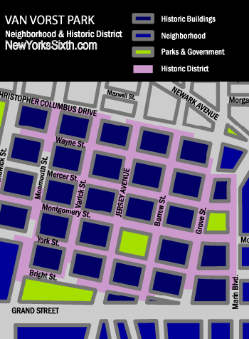
- Van Vorst Park is a neighborhood in the Historic Downtown of Jersey City, Hudson County, New Jersey, United States, centered on a park sharing the same name. The neighborhood is located west of Paulus Hook and Marin Boulevard, north of Grand Street, east of the Turnpike Extension, and south of The Village and Christopher Columbus Drive. Much of it is included in the Van Vorst Park Historical District. The park was a centerpiece of Van Vorst Township, a township that existed in Hudson County from 1841 to 1851. Van Vorst was incorporated as a township by an Act of the New Jersey Legislature on April 12, 1841, from portions of Bergen Township. On March 18, 1851, Van Vorst Township was annexed by Jersey City. The name Van Vorst comes from a prominent family in the area, the first of which arrived in the 1630s as superintendent of the patroonship Pavonia, the earliest European settlement on the west bank of the Hudson River in the province of New Netherland. His homestead at Harsimus, plus others at Communipaw, Paulus Hook, Minakwa, Pamrapo were later incorporated into Bergen. His namesake and eighth generation descendant, Cornelius Van Vorst, was the twelfth Mayor of Jersey City serving from 1860 to 1862. Like Harsimus Cove and Hamilton Park to the north and Bergen-Lafayette to the southwest, the neighborhood contains nineteenth century rowhouses and brownstones. It is home to the Jersey City Medical Center, James J. Ferris High School (named for the Jersey City citizen who laid the foundation of the Hudson and Manhattan Railroad Powerhouse with his firm Stillman, Delehanty and Ferris), and Old Colony Shopping Plaza. Landmarks include Barrow Mansion and Dixon Mills. The Grove Street PATH station is located nearby to the north and is the Jersey Avenue (HBLR station) to the south. (en)
|
| dbo:area
|
- 31160.794452 (xsd:double)
|
| dbo:location
| |
| dbo:nrhpReferenceNumber
| |
| dbo:thumbnail
| |
| dbo:wikiPageExternalLink
| |
| dbo:wikiPageID
| |
| dbo:wikiPageLength
|
- 7969 (xsd:nonNegativeInteger)
|
| dbo:wikiPageRevisionID
| |
| dbo:wikiPageWikiLink
|
- dbc:Neighborhoods_in_Jersey_City,_New_Jersey
- dbr:Barrow_Mansion
- dbr:Hudson_County,_New_Jersey
- dbr:Hudson_River
- dbr:Hudson_and_Manhattan_Railroad_Powerhouse
- dbr:Downtown_Jersey_City
- dbr:List_of_neighborhoods_in_Jersey_City,_New_Jersey
- dbr:Jersey_Avenue_(HBLR_station)
- dbr:Paulus_Hook
- dbc:Parks_in_Hudson_County,_New_Jersey
- dbr:Communipaw
- dbr:Grace_Church_Van_Vorst
- dbc:Parks_on_the_National_Register_of_Historic_Places_in_New_Jersey
- dbr:Cornelius_Van_Vorst
- dbr:Bergen,_New_Netherland
- dbr:Bergen-Lafayette,_Jersey_City
- dbc:Historic_districts_in_Hudson_County,_New_Jersey
- dbc:Squares_in_Jersey_City,_New_Jersey
- dbr:Pavonia,_New_Netherland
- dbr:Jersey_City_Medical_Center
- dbc:National_Register_of_Historic_Places_in_Hudson_County,_New_Jersey
- dbc:New_Jersey_Register_of_Historic_Places
- dbc:Houses_in_Hudson_County,_New_Jersey
- dbr:Greenville,_Jersey_City
- dbr:Hamilton_Park,_Jersey_City
- dbr:Harsimus
- dbr:Interstate_78_in_New_Jersey
- dbr:James_J._Ferris_High_School
- dbc:Houses_on_the_National_Register_of_Historic_Places_in_New_Jersey
- dbr:Jersey_City,_New_Jersey
- dbr:The_Village,_Jersey_City
- dbr:Dixon_Mills
- dbr:Grove_Street_(PATH_station)
- dbr:Brownstone
- dbr:New_Jersey
- dbr:New_Jersey_Legislature
- dbr:New_Netherland
- dbr:Van_Vorst_Township,_New_Jersey
- dbr:Pamrapo
- dbr:Township_(New_Jersey)
- dbr:Odonyms_in_Hudson_County,_New_Jersey
- dbr:List_of_mayors_of_Jersey_City
- dbr:Rowhouse
- dbr:List_of_Registered_Historic_Places_in_Hudson_County,_New_Jersey
- dbr:Patroonship
- dbr:Bergen_Township,_New_Jersey_(pre-1862)
- dbr:File:Gazebo_in_Van_Vorst_Park.jpg
|
| dbp:added
| |
| dbp:architecture
|
- Late 19th And 20th Century Revivals (en)
|
| dbp:designatedOther1Abbr
| |
| dbp:designatedOther1Color
| |
| dbp:designatedOther1Date
| |
| dbp:designatedOther1Link
|
- New Jersey Register of Historic Places (en)
|
| dbp:designatedOther1Name
|
- New Jersey Register of Historic Places (en)
|
| dbp:designatedOther1NumPosition
| |
| dbp:designatedOther1Number
| |
| dbp:location
|
- Roughly bounded by Mercer, Wayne, Montgomery, Grove, Bright, Varick and Monmouth Streets, Jersey City, New Jersey (en)
|
| dbp:locmapin
|
- USA New Jersey Hudson County#New Jersey#USA (en)
|
| dbp:name
|
- (en)
- Van Vorst Park Historic District (en)
|
| dbp:nocat
| |
| dbp:nrhpType
| |
| dbp:refnum
| |
| dbp:wikiPageUsesTemplate
| |
| dcterms:subject
| |
| gold:hypernym
| |
| georss:point
|
- 40.71861111111111 -74.04805555555555
|
| rdf:type
| |
| rdfs:comment
|
- Van Vorst Park es un vecindario en el centro histórico de la ciudad de Jersey, condado de Hudson, Nueva Jersey, Estados Unidos, centrado en un parque que comparte el mismo nombre. El vecindario está ubicado al oeste de Paulus Hook y Marin Boulevard, al norte de Grand Street, al este de y al sur de y Christopher Columbus Drive. Gran parte está incluida en el Distrito Histórico del Parque Van Vorst. La de la PATH está ubicada cerca al norte y es la avenida Jersey (estación HBLR) al sur. (es)
- Van Vorst Park is a neighborhood in the Historic Downtown of Jersey City, Hudson County, New Jersey, United States, centered on a park sharing the same name. The neighborhood is located west of Paulus Hook and Marin Boulevard, north of Grand Street, east of the Turnpike Extension, and south of The Village and Christopher Columbus Drive. Much of it is included in the Van Vorst Park Historical District. The Grove Street PATH station is located nearby to the north and is the Jersey Avenue (HBLR station) to the south. (en)
|
| rdfs:label
|
- Parque Van Vorst (es)
- Van Vorst Park (en)
|
| owl:sameAs
| |
| geo:geometry
|
- POINT(-74.048057556152 40.718612670898)
|
| geo:lat
| |
| geo:long
| |
| prov:wasDerivedFrom
| |
| foaf:depiction
| |
| foaf:isPrimaryTopicOf
| |
| foaf:name
|
- Van Vorst Park Historic District (en)
- (Boundary Increase) (en)
|
| is dbo:wikiPageRedirects
of | |
| is dbo:wikiPageWikiLink
of |
- dbr:Barrow_Mansion
- dbr:Bogus_(film)
- dbr:List_of_neighborhoods_in_Hudson_Waterfront_municipalities
- dbr:Downtown_Jersey_City
- dbr:List_of_neighborhoods_in_Hudson_County,_New_Jersey
- dbr:List_of_neighborhoods_in_Jersey_City,_New_Jersey
- dbr:List_of_place_names_of_Dutch_origin_in_the_United_States
- dbr:Communipaw
- dbr:Bergen,_New_Netherland
- dbr:Bergen-Lafayette,_Jersey_City
- dbr:Jersey_City_Museum
- dbr:Exchange_Place,_Jersey_City
- dbr:Palisade_Avenue_(Hudson_Palisades)
- dbr:Historic_districts_in_Hudson_County,_New_Jersey
- dbr:Joseph_Dixon_(inventor)
- dbr:The_Heights,_Jersey_City
- dbr:List_of_Hudson_County,_New_Jersey_placename_etymologies
- dbr:Hamilton_Park,_Jersey_City
- dbr:Harsimus
- dbr:Jacques_Singer
- dbr:Jersey_City,_New_Jersey
- dbr:Dixon_Mills
- dbr:Frederick_Clarke_Withers
- dbr:Hudson_Shakespeare_Company
- dbr:Brownstone
- dbr:Van_Vorst_Township,_New_Jersey
- dbr:Van_Vorst_House
- dbr:Van_Vorst_Park_Historic_District
|
| is foaf:primaryTopic
of | |


