| dbo:abstract
|
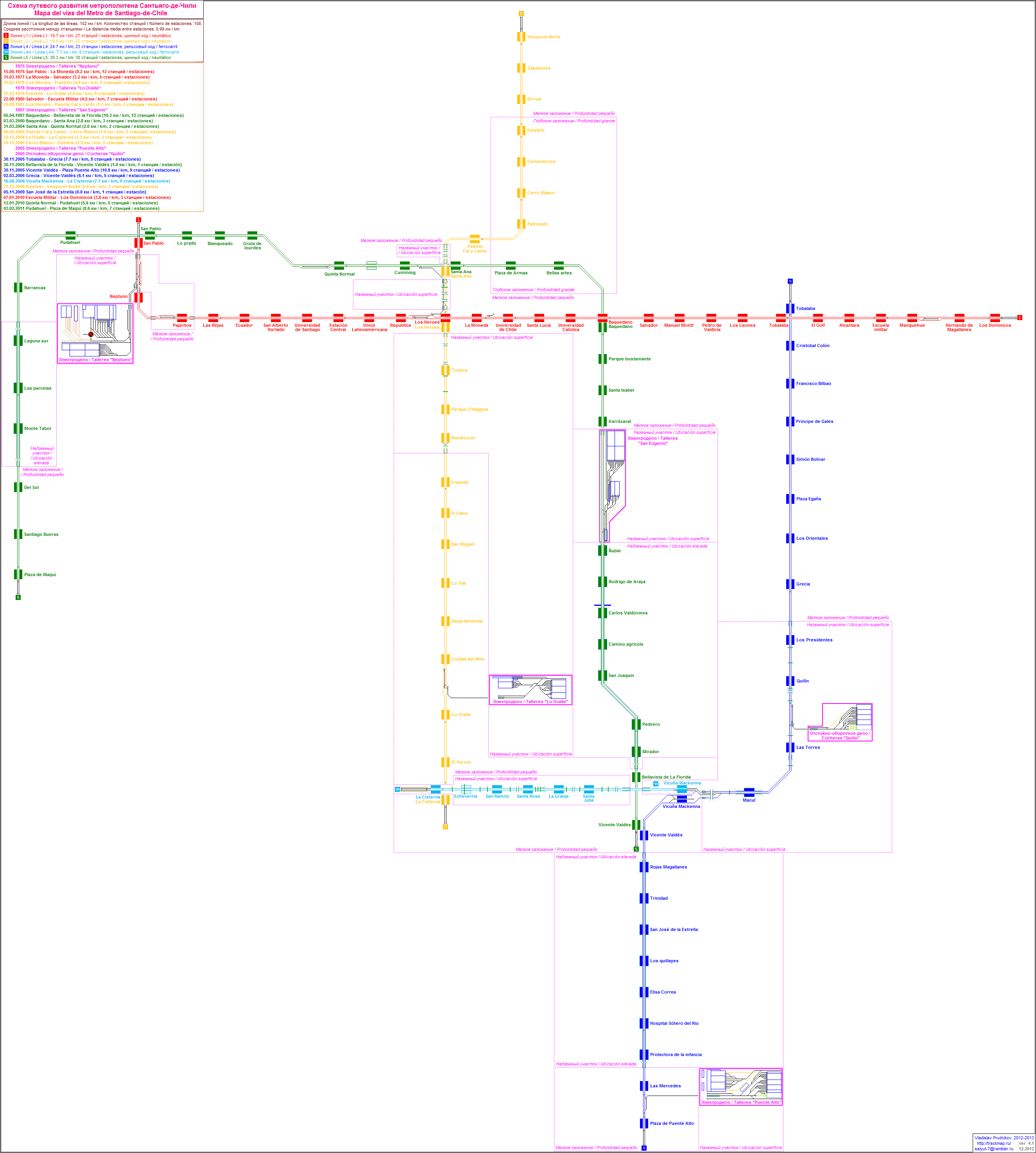
- La Línea 1 del Metro de Santiago es la más antigua de las siete líneas que conforman el ferrocarril metropolitano de la capital de Chile. Tiene un total de 27 estaciones a lo largo de sus 20,4 kilómetros construidos en cinco comunas, casi en su totalidad de forma subterránea. Ubicada principalmente a lo largo del eje formado por la Alameda del Libertador Bernardo O'Higgins y su continuación Providencia-Apoquindo, la Línea 1 es la principal línea y más utilizada de todas las que forman el Metro, realizando una función articuladora de toda la red. Se interconecta con la Línea 2 en la estación Los Héroes, con la Línea 3 en la estación Universidad de Chile, con la Línea 4 en la estación Tobalaba, con la Línea 5 en las estaciones San Pablo y Baquedano y con Línea 6 en la estación Los Leones. Asimismo hará lo propio con las futuras Línea 7, Línea 8 y Línea 9 en las estaciones Baquedano y Pedro de Valdivia, Los Leones y Santa Lucía, respectivamente, a partir de 2026 y 2027. El color distintivo es el rojo. En 2021, se realizaron 118,4 millones de viajes que representaron el 33% del total de los viajes efectuados en el Metro de Santiago, lo que la convierte en la más usada del sistema. (es)
- La ligne 1 est une des sept lignes du métro de Santiago, au Chili. Elle comporte vingt-sept stations réparties sur vingt kilomètres. (fr)
- Santiago Metro Line 1 is the oldest of the seven existing rapid transit lines that make up the Santiago Metro system. Being its busiest, it has a total of 27 stations along its 19.3 km (12.0 mi) length, constructed almost entirely underground (save for some open cut sections in the west), and is located primarily along the axis formed by the Avenida Libertador General Bernardo O'Higgins (Libertador General Bernardo O'Higgins Avenue, also known as the “Alameda”), Providencia Avenue and Apoquindo Avenue. In 2015, Line 1 accounted for 39.5% of all trips made on the metro system with a daily ridership of 705,200, making it the busiest line in the system. It currently connects with five of the six other lines – with Line 2 at Los Héroes station, with Line 3 at Universidad de Chile station, with Line 4 at Tobalaba station in the northeast, with Line 5 at both San Pablo station and Baquedano station and line 6 at Los Leones. There are plans for connections with the future Line 9 at Santa Lucía station, the future Line 7 at Baquedano and Pedro de Valdivia and the future Line 8 at Los Leones. Its distinctive colour on the network map is red. During the 2019 Chilean protests, several of the stations were burned and looted, with the closure of the entire system following soon afterwards. Since then, all of the stations have reopened. (en)
- Jalur 1 di angkutan cepat Santiago (bahasa Spanyol: Línea 1 del Metro de Santiago) merupakan jalur angkutan cepat pertama yang dibangun di Santiago, Chili. Konstruksi jalur ini dimulai pada tahun 1968 dan pertama kali dibuka pada tanggal 15 September 1975. Jalur ini dioperasikan oleh (in)
- Lijn 1 is een van de vijf lijnen die onderdeel zijn van de Metro van Santiago. Het traject bestaat uit 24 stations. Totale lengte is 14.9 kilometer. (nl)
- A Linha 1: San Pablo ↔ Los Dominicos é uma das linhas do Metrô de Santiago. (pt)
|
| dbo:isPartOf
| |
| dbo:lineLength
|
- 19300.000000 (xsd:double)
|
| dbo:location
| |
| dbo:numberOfStations
|
- 27 (xsd:nonNegativeInteger)
|
| dbo:openingDate
| |
| dbo:openingYear
| |
| dbo:railwayRollingStock
| |
| dbo:routeEnd
| |
| dbo:routeStart
| |
| dbo:speedLimit
| |
| dbo:status
| |
| dbo:thumbnail
| |
| dbo:type
| |
| dbo:wikiPageExternalLink
| |
| dbo:wikiPageID
| |
| dbo:wikiPageLength
|
- 16647 (xsd:nonNegativeInteger)
|
| dbo:wikiPageRevisionID
| |
| dbo:wikiPageWikiLink
| |
| dbp:caption
| |
| dbp:character
|
- Underground (en)
- Open cut (en)
|
| dbp:color
| |
| dbp:dailyRidership
| |
| dbp:depot
| |
| dbp:electrification
| |
| dbp:end
| |
| dbp:imageWidth
| |
| dbp:locale
|
- Western, central and northeast Santiago (en)
|
| dbp:logo
|
- Santiago de Chile L1.svg (en)
|
| dbp:logoAlt
|
- Santiago Metro Line 1 logo (en)
|
| dbp:logoWidth
| |
| dbp:mapState
| |
| dbp:name
|
- Santiago Metro Line 1 (en)
|
| dbp:open
| |
| dbp:operator
|
- Empresa de Transporte de Pasajeros Metro S.A. (en)
|
| dbp:owner
|
- Empresa de Transporte de Pasajeros Metro S.A. (en)
|
| dbp:start
| |
| dbp:stations
| |
| dbp:status
| |
| dbp:stock
|
- GEC-Alsthom Metropolis NS 93, CAF and (en)
|
| dbp:system
| |
| dbp:type
| |
| dbp:wikiPageUsesTemplate
| |
| dcterms:subject
| |
| rdf:type
| |
| rdfs:comment
|
- La ligne 1 est une des sept lignes du métro de Santiago, au Chili. Elle comporte vingt-sept stations réparties sur vingt kilomètres. (fr)
- Jalur 1 di angkutan cepat Santiago (bahasa Spanyol: Línea 1 del Metro de Santiago) merupakan jalur angkutan cepat pertama yang dibangun di Santiago, Chili. Konstruksi jalur ini dimulai pada tahun 1968 dan pertama kali dibuka pada tanggal 15 September 1975. Jalur ini dioperasikan oleh (in)
- Lijn 1 is een van de vijf lijnen die onderdeel zijn van de Metro van Santiago. Het traject bestaat uit 24 stations. Totale lengte is 14.9 kilometer. (nl)
- A Linha 1: San Pablo ↔ Los Dominicos é uma das linhas do Metrô de Santiago. (pt)
- La Línea 1 del Metro de Santiago es la más antigua de las siete líneas que conforman el ferrocarril metropolitano de la capital de Chile. Tiene un total de 27 estaciones a lo largo de sus 20,4 kilómetros construidos en cinco comunas, casi en su totalidad de forma subterránea. En 2021, se realizaron 118,4 millones de viajes que representaron el 33% del total de los viajes efectuados en el Metro de Santiago, lo que la convierte en la más usada del sistema. (es)
- Santiago Metro Line 1 is the oldest of the seven existing rapid transit lines that make up the Santiago Metro system. Being its busiest, it has a total of 27 stations along its 19.3 km (12.0 mi) length, constructed almost entirely underground (save for some open cut sections in the west), and is located primarily along the axis formed by the Avenida Libertador General Bernardo O'Higgins (Libertador General Bernardo O'Higgins Avenue, also known as the “Alameda”), Providencia Avenue and Apoquindo Avenue. (en)
|
| rdfs:label
|
- Santiago Metro Line 1 (en)
- Línea 1 del Metro de Santiago (es)
- Jalur 1 (angkutan cepat Santiago) (in)
- Ligne 1 du métro de Santiago (fr)
- Lijn 1 (metro van Santiago) (nl)
- Linha 1 do Metrô de Santiago (pt)
|
| owl:sameAs
| |
| prov:wasDerivedFrom
| |
| foaf:depiction
| |
| foaf:isPrimaryTopicOf
| |
| foaf:name
|
- Santiago Metro Line 1 (en)
|
| is dbo:wikiPageDisambiguates
of | |
| is dbo:wikiPageRedirects
of | |
| is dbo:wikiPageWikiLink
of | |
| is foaf:primaryTopic
of | |


