| dbo:abstract
|
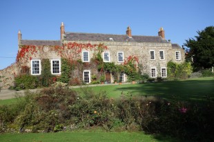
- Low Walworth is a hamlet in County Durham, England, 1.5 miles (2.4 km) to the north−west of the edge of Darlington. It consists of Low Walworth Hall, Low Walworth Farm and their respective cottages, flats and outbuildings. Several of these buildings are listed, and date from the 17th to the 19th century. Attached to one of the late-18th-century farm buildings is a gin gang, or building from which a horse powered a threshing machine by walking in a circle. The hall has accommodated at least one High Sheriff of Durham. (en)
- Low Walworth – osada w Anglii, w hrabstwie ceremonialnym Durham, w dystrykcie (unitary authority) Darlington. Leży 24 km na południe od miasta Durham i 355 km na północ od Londynu. (pl)
|
| dbo:areaCode
| |
| dbo:ceremonialCounty
| |
| dbo:country
| |
| dbo:gridReference
| |
| dbo:postalCode
| |
| dbo:thumbnail
| |
| dbo:wikiPageExternalLink
| |
| dbo:wikiPageID
| |
| dbo:wikiPageLength
|
- 8778 (xsd:nonNegativeInteger)
|
| dbo:wikiPageRevisionID
| |
| dbo:wikiPageWikiLink
| |
| dbp:centre
| |
| dbp:constituencyWestminster
| |
| dbp:country
| |
| dbp:dialCode
| |
| dbp:east
| |
| dbp:labelPosition
| |
| dbp:lieutenancyEngland
| |
| dbp:north
| |
| dbp:northeast
| |
| dbp:northwest
| |
| dbp:officialName
| |
| dbp:osGridReference
| |
| dbp:postTown
| |
| dbp:postcodeArea
| |
| dbp:postcodeDistrict
| |
| dbp:region
| |
| dbp:south
| |
| dbp:southeast
| |
| dbp:southwest
| |
| dbp:staticImageCaption
|
- Low Walworth Hall viewed from the west (en)
|
| dbp:staticImageName
|
- Low Walworth Hall. - geograph.org.uk - 162022.jpg (en)
|
| dbp:unitaryEngland
| |
| dbp:west
| |
| dbp:wikiPageUsesTemplate
| |
| dcterms:subject
| |
| gold:hypernym
| |
| georss:point
| |
| rdf:type
| |
| rdfs:comment
|
- Low Walworth is a hamlet in County Durham, England, 1.5 miles (2.4 km) to the north−west of the edge of Darlington. It consists of Low Walworth Hall, Low Walworth Farm and their respective cottages, flats and outbuildings. Several of these buildings are listed, and date from the 17th to the 19th century. Attached to one of the late-18th-century farm buildings is a gin gang, or building from which a horse powered a threshing machine by walking in a circle. The hall has accommodated at least one High Sheriff of Durham. (en)
- Low Walworth – osada w Anglii, w hrabstwie ceremonialnym Durham, w dystrykcie (unitary authority) Darlington. Leży 24 km na południe od miasta Durham i 355 km na północ od Londynu. (pl)
|
| rdfs:label
|
- Low Walworth (en)
- Low Walworth (pl)
|
| owl:sameAs
| |
| geo:geometry
|
- POINT(-1.6440000534058 54.56600189209)
|
| geo:lat
| |
| geo:long
| |
| prov:wasDerivedFrom
| |
| foaf:depiction
| |
| foaf:isPrimaryTopicOf
| |
| foaf:name
| |
| is dbo:wikiPageDisambiguates
of | |
| is dbo:wikiPageWikiLink
of | |
| is dbp:northeast
of | |
| is dbp:northwest
of | |
| is dbp:southeast
of | |
| is foaf:primaryTopic
of | |


