| dbo:abstract
|
- Terumbu Semarang Barat Kecil (englisch Louisa Reef) ist ein Korallenriff im südlichen Teil der Spratly-Inseln im Südchinesischen Meer. Terumbu Semarang Barat Kecil bedeutet wörtlich Kleines Westliches Semarang-Riff. Entsprechend gibt es auch ein Großes Westliches Semarang-Riff, (englisch Royal Charlotte Reef) weiter südwestlich. (de)
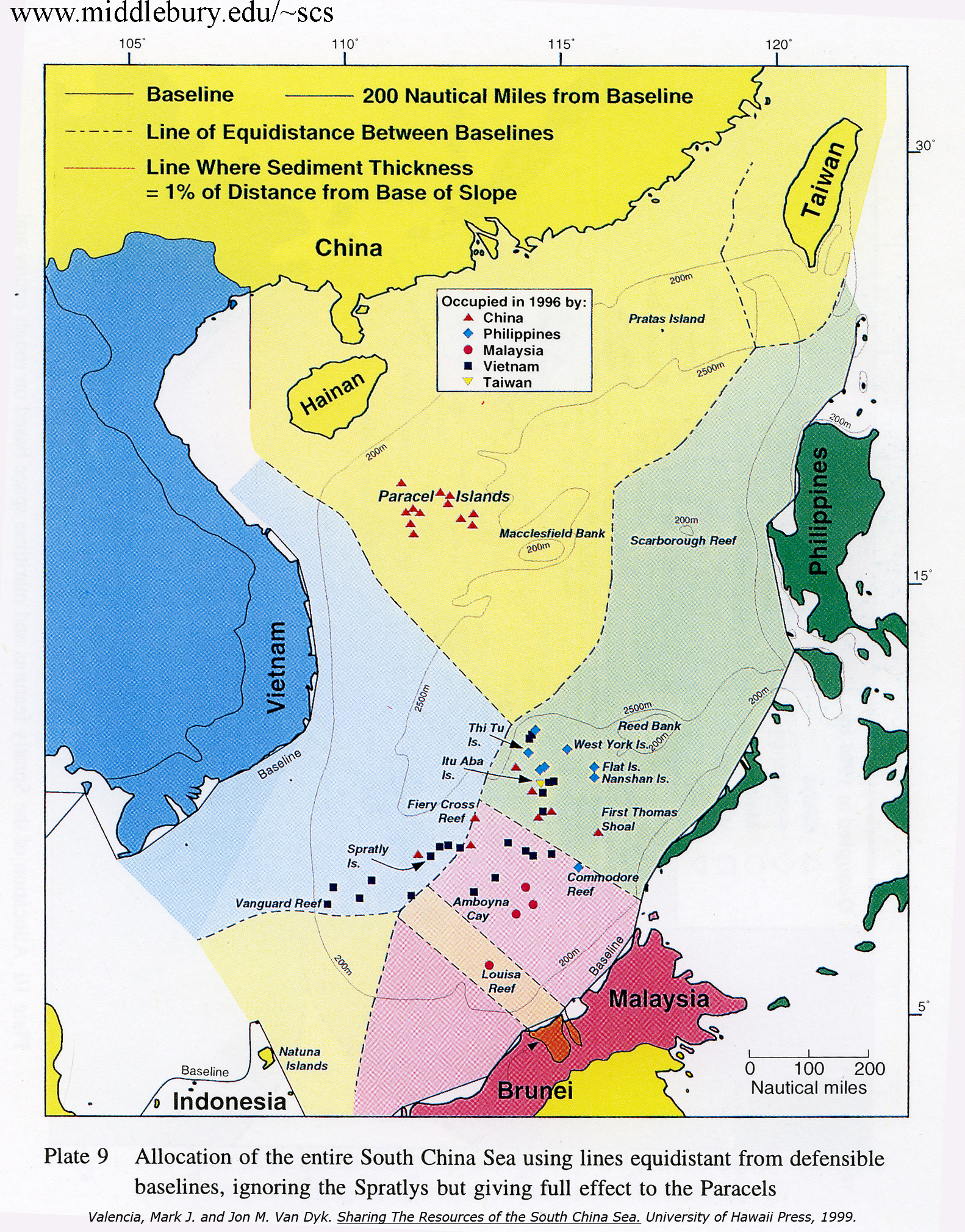
- Louisa Reef (Brunei Malay: Terumbu Semarang Barat Kecil; Mandarin Chinese: 南通礁; pinyin: Nántōng Jiāo) is a coral atoll in the southern reaches of the Spratly Islands. The reef is oval in shape, approximately 1.5 km (1 mile) east to west and 0.5 km (500 yards) north to south. While most of Louisa Reef is submerged, some portions emerge at low tide and a few small rocks remain above water even at high tide. The atoll rises as deeply undercut walls and steep slopes from very deep water with extensive stony and soft corals. A navigation beacon built by Malaysia is at its southwest point and the highest visible rock is at the southeast end. Safe anchorage is difficult to find, depending on the wind and currents, but there are sandy areas at the northwest and southwest ends. The nearest reliable shelter for boats is the lagoon at Swallow Reef, 128 km (80 miles) to the northeast. As of 2014, the shoal was claimed by Brunei, China, and Taiwan. Malaysia previously claimed Louisa Reef and operated a small obelisk-like concrete navigational light beacon there. However, Malaysia has apparently dropped its claim in deference to the claim of neighbouring Brunei that the reef lies on its continental shelf. (en)
- Le récif Louisa, également nommé Nantong Jiao (南通礁) par les chinois et Terumbu Semarang Barat Kecil en Malais de Brunei, est un récif situé dans la partie sud des îles Spratleys. Il se situe à 128km au sud-sud-ouest du récif Swallow. En malais, Terumba Semarang Barat Kecil signifie littéralement le petit récif Semarang occidental, par opposition à un grand récif Semarang occidental, (le Royal Charlotte Reef ) au sud-ouest. (fr)
- Karang Louisa (bahasa Melayu: Terumbu Semarang Barat Kecil; Hanzi: 南通礁; Pinyin: Nántōng Jiāo) adalah sebuah di selatan Kepulauan Spratly. Karang tersebut berbentuk oval, berukuran sekitar 1.5 km dari timur ke barat dan 0.5 km dari utara ke selatan. (in)
- 南通礁(中国名。英語:Louisa Reef、マレー語:Terumbu Semarang Barat Kecil)は、南沙諸島にある環礁である。現在、ブルネイ、中華人民共和国、中華民国(台湾)が主権を主張している。 (ja)
- Nantong Jiao är en klippa bland Spratlyöarna i Sydkinesiska havet. Kina betraktar den som sitt territorium, något som inte erkänns av grannländer som Vietnam och Taiwan. (sv)
- 南通礁位于南沙群岛南部,皇路礁西南约42海里,是一座完整的环礁,低潮时出露,无礁门。由于出露时环礁成节不连续,故中国渔民向称“丹积”或“丹节”。1935年中华民国水陆地图审查委员会公布的名称为“路易萨礁”。1947年中华民国内政部方域司公布的和1983年中华人民共和国中国地名委员会公布的标准名称均为“南通礁”。英文名称为“Louisa Reef”。 目前汶萊实际控制该岛,中华人民共和国、中華民國政府皆宣称拥有其主权。南通礁也是文莱唯一在南海提出主权声索的岛礁。马来西亚在岛上修建了一座灯塔,但已经不再工作。 (zh)
|
| dbo:thumbnail
| |
| dbo:wikiPageExternalLink
| |
| dbo:wikiPageID
| |
| dbo:wikiPageLength
|
- 3730 (xsd:nonNegativeInteger)
|
| dbo:wikiPageRevisionID
| |
| dbo:wikiPageWikiLink
| |
| dbp:archipelago
| |
| dbp:c
| |
| dbp:country1Claim
| |
| dbp:country1ClaimDivisions
| |
| dbp:country1ClaimDivisionsTitle
| |
| dbp:country2Claim
| |
| dbp:country2ClaimDivisions
| |
| dbp:country2ClaimDivisionsTitle
| |
| dbp:countryClaim
| |
| dbp:countryClaimDivisions
| |
| dbp:countryClaimDivisionsTitle
| |
| dbp:imageCaption
| |
| dbp:imageName
|
- Louisa 2022-08-29-00 00 2022-08-29-23 59 Sentinel-2 L2A True color.jpg (en)
|
| dbp:imageSize
| |
| dbp:location
| |
| dbp:name
| |
| dbp:otherNames
|
- Terumbu Semarang Barat Kecil (en)
- 南通礁 Nántōng Jiāo (en)
|
| dbp:p
| |
| dbp:pushpinMap
|
- Spratly Islands relief (en)
|
| dbp:wikiPageUsesTemplate
| |
| dcterms:subject
| |
| georss:point
|
- 6.335277777777778 113.27972222222222
|
| rdf:type
| |
| rdfs:comment
|
- Terumbu Semarang Barat Kecil (englisch Louisa Reef) ist ein Korallenriff im südlichen Teil der Spratly-Inseln im Südchinesischen Meer. Terumbu Semarang Barat Kecil bedeutet wörtlich Kleines Westliches Semarang-Riff. Entsprechend gibt es auch ein Großes Westliches Semarang-Riff, (englisch Royal Charlotte Reef) weiter südwestlich. (de)
- Le récif Louisa, également nommé Nantong Jiao (南通礁) par les chinois et Terumbu Semarang Barat Kecil en Malais de Brunei, est un récif situé dans la partie sud des îles Spratleys. Il se situe à 128km au sud-sud-ouest du récif Swallow. En malais, Terumba Semarang Barat Kecil signifie littéralement le petit récif Semarang occidental, par opposition à un grand récif Semarang occidental, (le Royal Charlotte Reef ) au sud-ouest. (fr)
- Karang Louisa (bahasa Melayu: Terumbu Semarang Barat Kecil; Hanzi: 南通礁; Pinyin: Nántōng Jiāo) adalah sebuah di selatan Kepulauan Spratly. Karang tersebut berbentuk oval, berukuran sekitar 1.5 km dari timur ke barat dan 0.5 km dari utara ke selatan. (in)
- 南通礁(中国名。英語:Louisa Reef、マレー語:Terumbu Semarang Barat Kecil)は、南沙諸島にある環礁である。現在、ブルネイ、中華人民共和国、中華民国(台湾)が主権を主張している。 (ja)
- Nantong Jiao är en klippa bland Spratlyöarna i Sydkinesiska havet. Kina betraktar den som sitt territorium, något som inte erkänns av grannländer som Vietnam och Taiwan. (sv)
- 南通礁位于南沙群岛南部,皇路礁西南约42海里,是一座完整的环礁,低潮时出露,无礁门。由于出露时环礁成节不连续,故中国渔民向称“丹积”或“丹节”。1935年中华民国水陆地图审查委员会公布的名称为“路易萨礁”。1947年中华民国内政部方域司公布的和1983年中华人民共和国中国地名委员会公布的标准名称均为“南通礁”。英文名称为“Louisa Reef”。 目前汶萊实际控制该岛,中华人民共和国、中華民國政府皆宣称拥有其主权。南通礁也是文莱唯一在南海提出主权声索的岛礁。马来西亚在岛上修建了一座灯塔,但已经不再工作。 (zh)
- Louisa Reef (Brunei Malay: Terumbu Semarang Barat Kecil; Mandarin Chinese: 南通礁; pinyin: Nántōng Jiāo) is a coral atoll in the southern reaches of the Spratly Islands. The reef is oval in shape, approximately 1.5 km (1 mile) east to west and 0.5 km (500 yards) north to south. While most of Louisa Reef is submerged, some portions emerge at low tide and a few small rocks remain above water even at high tide. The atoll rises as deeply undercut walls and steep slopes from very deep water with extensive stony and soft corals. A navigation beacon built by Malaysia is at its southwest point and the highest visible rock is at the southeast end. (en)
|
| rdfs:label
|
- Terumbu Semarang Barat Kecil (de)
- Karang Louisa (in)
- Récif Louisa (fr)
- 南通礁 (ja)
- Louisa Reef (en)
- Nantong Jiao (sv)
- 南通礁 (zh)
|
| owl:sameAs
| |
| geo:geometry
|
- POINT(113.27972412109 6.335277557373)
|
| geo:lat
| |
| geo:long
| |
| prov:wasDerivedFrom
| |
| foaf:depiction
| |
| foaf:isPrimaryTopicOf
| |
| is dbo:wikiPageDisambiguates
of | |
| is dbo:wikiPageWikiLink
of | |
| is foaf:primaryTopic
of | |


_(cropped).jpg)
.jpg)
_(cropped).jpg)