| dbo:PopulatedPlace/areaTotal
| |
| dbo:PopulatedPlace/populationDensity
| |
| dbo:abstract
|
- Hamarøy (en noruec) o Hábmer (en sami de Lule) és un municipi situat al comtat de Nordland, Noruega. Té 1,801 habitants (2018) i la seva superfície és de 1,029.95 km². El centre administratiu del municipi és el poble d'Oppeid. Els altres pobles de Hamarøy/Hábmer són , , , , , , i . (ca)
- Hamarøy estas komunumo de Norvegio. Ĝi apartenas al la departemento Nordland. Fine de 2022 en la komunumo vivis 2 708 loĝantoj. (eo)
- Hamarøy (lulesamisch Hábmer) ist eine Kommune in der nordnorwegischen Provinz Nordland. Ihr Verwaltungszentrum heißt Oppeid. Im Zuge der Kommunalreform in Norwegen wurde der südwestliche Teil von Tysfjord zum 1. Januar 2020 mit Hamarøy zusammengelegt. Die Einwohnerzahl von 1747 bezieht sich auf die Kommune vor der Eingliederung von Tysfjord. (de)
- Hamarøy (Lule Sami: Hábmer) is a municipality in Nordland county, Norway. It is part of the traditional district of Salten. The administrative centre of the municipality is the village of Oppeid. Other villages include Drag, , Karlsøy, Korsnes, Presteid, Skutvika, Tømmerneset, Tranøy, and . The 2,020-square-kilometre (780 sq mi) municipality is the 36th largest by area out of the 356 municipalities in Norway. Hamarøy is the 242nd most populous municipality in Norway with a population of 2,708. The municipality's population density is 1.5 inhabitants per square kilometre (3.9/sq mi) and its population has decreased by 3.3% over the previous 10-year period. (en)
- Hamarøy Norvegiako udalerria da. Nordland konderrian kokatua dago. 1031.29 km² ditu eta 1.761 biztanle ditu. (eu)
- Hamarøy es un municipio de la provincia de Nordland en la región de Nord-Norge, Noruega. A 1 de enero de 2018 tenía una población estimada de 1801 habitantes. Se encuentra ubicado en la costa noroccidental de la península escandinava, cerca del fiordo Ofotfjord. (es)
- Hamarøy de son nom norvégien (ou Hábmer en same de Lule) est une kommune de Norvège. Elle est située dans le comté de Nordland. Le chef-lieu de la commune est le village d' Oppeid. (fr)
- Hamarøy ialah sebuah di , Nordland, Norwegia. Luas kotamadya ini 1.031 km² dan penduduknya 2.000 jiwa. Pusat administratifnya ada di . (in)
- Hamarøy è un comune norvegese della contea di Nordland. (it)
- Hamarøy (Lule-Samisch:Hábmer) is een gemeente in de Noorse provincie Nordland. De gemeente telde 1810 inwoners in januari 2017. Vanaf het dorp Skutvik is er een veerverbinding naar Lofoten. (nl)
- Хамарёй — коммуна в фюльке Нурланн в Норвегии. Является частью региона Сальтен. Административный центр коммуны — деревня Оппейд. Хамарёй был официально признан коммуной 1 января 1838 года. (ru)
- Hamarøy – norweskie miasto i gmina leżąca w regionie Nordland. Hamarøy jest 101. norweską gminą pod względem powierzchni. (pl)
- Hamarøy é uma comuna da Noruega, com 566 km² de área e 1 872 habitantes (censo de 2004). Localiza-se aqui o Centro Knut Hamsun, dedicado ao prémio Nobel da Literatura Knut Hamsun. O edifício foi desenhado por Steven Holl. (pt)
- Hamarøy kommun (lulesamiska: Hábmera suohkan) är en kommun i regionen och landskapet Salten i Nordland fylke i Norge. Den administrativa huvudorten är . Hamarøy kommun ingår i Förvaltningsområdet för samiska språk. Språkvariteten är lulesamiska, den enda norska kommunen med lulesamiska. (sv)
- 哈馬略(挪威語:Hamarøy)是挪威的一個市镇,位於諾爾蘭郡。 (zh)
|
| dbo:areaLand
|
- 1837610000.000000 (xsd:double)
|
| dbo:areaTotal
|
- 2020450000.000000 (xsd:double)
|
| dbo:areaWater
|
- 182840000.000000 (xsd:double)
|
| dbo:percentageOfAreaWater
| |
| dbo:populationDensity
| |
| dbo:populationTotal
|
- 2708 (xsd:nonNegativeInteger)
|
| dbo:thumbnail
| |
| dbo:wikiPageExternalLink
| |
| dbo:wikiPageID
| |
| dbo:wikiPageLength
|
- 29642 (xsd:nonNegativeInteger)
|
| dbo:wikiPageRevisionID
| |
| dbo:wikiPageWikiLink
| |
| dbp:aprMeanC
| |
| dbp:aprPrecipitationMm
| |
| dbp:arbeiderpartiet
|
- 3 (xsd:integer)
- 4 (xsd:integer)
- 6 (xsd:integer)
- 7 (xsd:integer)
- 8 (xsd:integer)
- 9 (xsd:integer)
- 11 (xsd:integer)
|
| dbp:areaLandKm
| |
| dbp:areaRank
| |
| dbp:areaTotalKm
| |
| dbp:areaWaterKm
| |
| dbp:areaWaterPercent
| |
| dbp:augMeanC
| |
| dbp:augPrecipitationMm
| |
| dbp:borgerligeFelleslister
|
- 8 (xsd:integer)
- 9 (xsd:integer)
- 10 (xsd:integer)
- 11 (xsd:integer)
- 12 (xsd:integer)
|
| dbp:capital
| |
| dbp:coatofarms
|
- Coat of arms of NO 1875 Hamarøy 2020.svg (en)
|
| dbp:collapsed
| |
| dbp:county
| |
| dbp:decMeanC
| |
| dbp:decPrecipitationMm
| |
| dbp:demonyms
|
- Hamarøying (en)
- Hamarøyværing (en)
|
| dbp:district
| |
| dbp:end
|
- 1941 (xsd:integer)
- 1947 (xsd:integer)
- 1951 (xsd:integer)
- 1955 (xsd:integer)
- 1959 (xsd:integer)
- 1963 (xsd:integer)
- 1967 (xsd:integer)
- 1971 (xsd:integer)
- 1975 (xsd:integer)
- 1979 (xsd:integer)
- 1983 (xsd:integer)
- 1987 (xsd:integer)
- 1991 (xsd:integer)
- 1995 (xsd:integer)
- 1999 (xsd:integer)
- 2003 (xsd:integer)
- 2007 (xsd:integer)
- 2011 (xsd:integer)
- 2015 (xsd:integer)
- 2019 (xsd:integer)
- 2023 (xsd:integer)
|
| dbp:established
| |
| dbp:febMeanC
| |
| dbp:febPrecipitationMm
| |
| dbp:flag
| |
| dbp:fremskrittspartiet
| |
| dbp:geoCat
| |
| dbp:herad
| |
| dbp:høyre
|
- 3 (xsd:integer)
- 4 (xsd:integer)
- 5 (xsd:integer)
- 6 (xsd:integer)
- 7 (xsd:integer)
|
| dbp:idnumber
| |
| dbp:imageCaption
|
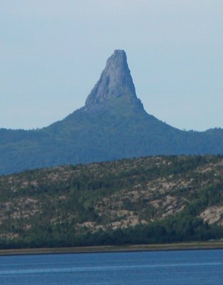
- View near Tømmernes in Hamarøy (en)
|
| dbp:imageSkyline
| |
| dbp:janMeanC
| |
| dbp:janPrecipitationMm
| |
| dbp:julMeanC
| |
| dbp:julPrecipitationMm
| |
| dbp:junMeanC
| |
| dbp:junPrecipitationMm
| |
| dbp:kristeligFolkeparti
|
- 1 (xsd:integer)
- 2 (xsd:integer)
- 3 (xsd:integer)
- 4 (xsd:integer)
- 5 (xsd:integer)
- 7 (xsd:integer)
|
| dbp:language
| |
| dbp:localLists
|
- 1 (xsd:integer)
- 3 (xsd:integer)
- 4 (xsd:integer)
|
| dbp:location
| |
| dbp:marMeanC
| |
| dbp:marPrecipitationMm
| |
| dbp:mayMeanC
| |
| dbp:mayPrecipitationMm
| |
| dbp:mayor
| |
| dbp:mayorAsOf
| |
| dbp:mayorParty
| |
| dbp:metricFirst
| |
| dbp:name
| |
| dbp:nativeName
| |
| dbp:nativeNameLang
| |
| dbp:novMeanC
| |
| dbp:novPrecipitationMm
| |
| dbp:octMeanC
| |
| dbp:octPrecipitationMm
| |
| dbp:otherparty
|
- Collaboration list (en)
- Hamarøy Free Voters (en)
|
| dbp:otherpartyNo
|
- Hamarøy Frie Velgere (en)
- Samarbeidslista (en)
|
| dbp:otherpartyNumber
|
- 3 (xsd:integer)
- 4 (xsd:integer)
- 5 (xsd:integer)
|
| dbp:populationAsOf
| |
| dbp:populationDensityKm
| |
| dbp:populationIncrease
| |
| dbp:populationRank
| |
| dbp:populationTotal
| |
| dbp:preceded
| |
| dbp:precipitationColour
| |
| dbp:samiLanguage
| |
| dbp:senterpartiet
|
- 2 (xsd:integer)
- 3 (xsd:integer)
- 4 (xsd:integer)
- 5 (xsd:integer)
- 6 (xsd:integer)
|
| dbp:sepMeanC
| |
| dbp:sepPrecipitationMm
| |
| dbp:singleLine
| |
| dbp:smallparty
|
- (en)
- Joint list of the Liberal Party and politically independent voters (en)
- Joint list of the Liberal Party and political independents (en)
|
| dbp:smallpartyColor
| |
| dbp:smallpartyNo
|
- Venstre og partipolitisk uavhengige velgere (en)
- Samarbeidslista Venstre og partipolitisk uavhengige (en)
|
| dbp:smallpartyNumber
|
- 2 (xsd:integer)
- 4 (xsd:integer)
- 8 (xsd:integer)
|
| dbp:sosialistiskVenstreparti
|
- 1 (xsd:integer)
- 2 (xsd:integer)
|
| dbp:source
| |
| dbp:sp/v
| |
| dbp:start
|
- 1938 (xsd:integer)
- 1945 (xsd:integer)
- 1948 (xsd:integer)
- 1952 (xsd:integer)
- 1956 (xsd:integer)
- 1960 (xsd:integer)
- 1964 (xsd:integer)
- 1968 (xsd:integer)
- 1972 (xsd:integer)
- 1976 (xsd:integer)
- 1980 (xsd:integer)
- 1984 (xsd:integer)
- 1988 (xsd:integer)
- 1992 (xsd:integer)
- 1996 (xsd:integer)
- 2000 (xsd:integer)
- 2004 (xsd:integer)
- 2008 (xsd:integer)
- 2012 (xsd:integer)
- 2016 (xsd:integer)
- 2020 (xsd:integer)
|
| dbp:total
|
- 17 (xsd:integer)
- 21 (xsd:integer)
- 24 (xsd:integer)
- 25 (xsd:integer)
|
| dbp:utmEasting
| |
| dbp:utmNorthing
| |
| dbp:utmZone
| |
| dbp:venstre
|
- 1 (xsd:integer)
- 4 (xsd:integer)
|
| dbp:webpage
|
- www.hamaroy.kommune.no (en)
|
| dbp:wikiPageUsesTemplate
| |
| dcterms:subject
| |
| gold:hypernym
| |
| georss:point
|
- 68.07583333333334 15.782222222222222
|
| rdf:type
| |
| rdfs:comment
|
- Hamarøy (en noruec) o Hábmer (en sami de Lule) és un municipi situat al comtat de Nordland, Noruega. Té 1,801 habitants (2018) i la seva superfície és de 1,029.95 km². El centre administratiu del municipi és el poble d'Oppeid. Els altres pobles de Hamarøy/Hábmer són , , , , , , i . (ca)
- Hamarøy estas komunumo de Norvegio. Ĝi apartenas al la departemento Nordland. Fine de 2022 en la komunumo vivis 2 708 loĝantoj. (eo)
- Hamarøy (lulesamisch Hábmer) ist eine Kommune in der nordnorwegischen Provinz Nordland. Ihr Verwaltungszentrum heißt Oppeid. Im Zuge der Kommunalreform in Norwegen wurde der südwestliche Teil von Tysfjord zum 1. Januar 2020 mit Hamarøy zusammengelegt. Die Einwohnerzahl von 1747 bezieht sich auf die Kommune vor der Eingliederung von Tysfjord. (de)
- Hamarøy Norvegiako udalerria da. Nordland konderrian kokatua dago. 1031.29 km² ditu eta 1.761 biztanle ditu. (eu)
- Hamarøy es un municipio de la provincia de Nordland en la región de Nord-Norge, Noruega. A 1 de enero de 2018 tenía una población estimada de 1801 habitantes. Se encuentra ubicado en la costa noroccidental de la península escandinava, cerca del fiordo Ofotfjord. (es)
- Hamarøy de son nom norvégien (ou Hábmer en same de Lule) est une kommune de Norvège. Elle est située dans le comté de Nordland. Le chef-lieu de la commune est le village d' Oppeid. (fr)
- Hamarøy ialah sebuah di , Nordland, Norwegia. Luas kotamadya ini 1.031 km² dan penduduknya 2.000 jiwa. Pusat administratifnya ada di . (in)
- Hamarøy è un comune norvegese della contea di Nordland. (it)
- Hamarøy (Lule-Samisch:Hábmer) is een gemeente in de Noorse provincie Nordland. De gemeente telde 1810 inwoners in januari 2017. Vanaf het dorp Skutvik is er een veerverbinding naar Lofoten. (nl)
- Хамарёй — коммуна в фюльке Нурланн в Норвегии. Является частью региона Сальтен. Административный центр коммуны — деревня Оппейд. Хамарёй был официально признан коммуной 1 января 1838 года. (ru)
- Hamarøy – norweskie miasto i gmina leżąca w regionie Nordland. Hamarøy jest 101. norweską gminą pod względem powierzchni. (pl)
- Hamarøy é uma comuna da Noruega, com 566 km² de área e 1 872 habitantes (censo de 2004). Localiza-se aqui o Centro Knut Hamsun, dedicado ao prémio Nobel da Literatura Knut Hamsun. O edifício foi desenhado por Steven Holl. (pt)
- Hamarøy kommun (lulesamiska: Hábmera suohkan) är en kommun i regionen och landskapet Salten i Nordland fylke i Norge. Den administrativa huvudorten är . Hamarøy kommun ingår i Förvaltningsområdet för samiska språk. Språkvariteten är lulesamiska, den enda norska kommunen med lulesamiska. (sv)
- 哈馬略(挪威語:Hamarøy)是挪威的一個市镇,位於諾爾蘭郡。 (zh)
- Hamarøy (Lule Sami: Hábmer) is a municipality in Nordland county, Norway. It is part of the traditional district of Salten. The administrative centre of the municipality is the village of Oppeid. Other villages include Drag, , Karlsøy, Korsnes, Presteid, Skutvika, Tømmerneset, Tranøy, and . (en)
|
| rdfs:label
|
- Hamarøy (en)
- Hamarøy (ca)
- Hamarøy (de)
- Hamarøy (eo)
- Hamarøy (es)
- Hamarøy (eu)
- Hamarøy (in)
- Hamarøy (fr)
- Hamarøy (it)
- Hamarøy (nl)
- Hamarøy (pl)
- Hamarøy (pt)
- Хамарёй (ru)
- Hamarøy kommun (sv)
- 哈馬略 (zh)
|
| owl:sameAs
| |
| geo:geometry
|
- POINT(15.782221794128 68.075836181641)
|
| geo:lat
| |
| geo:long
| |
| prov:wasDerivedFrom
| |
| foaf:depiction
| |
| foaf:isPrimaryTopicOf
| |
| foaf:name
|
- Hamarøy (en)
- Nordland (en)
- Hábmera suohkan (en)
|
| is dbo:birthPlace
of | |
| is dbo:hometown
of | |
| is dbo:location
of | |
| is dbo:subdivision
of | |
| is dbo:wikiPageRedirects
of | |
| is dbo:wikiPageWikiLink
of | |
| is dbp:birthPlace
of | |
| is dbp:location
of | |
| is dbp:subdivisionName
of | |
| is rdfs:seeAlso
of | |
| is foaf:primaryTopic
of | |


