| dbo:abstract
|
- الحافة القارية هي واحدةٌ من ثلاثة مناطق ينقسمُ إليها قاع المحيط (وأما الاثنتان الأخريان فهما أحواض أعماق المحيط وجروف وسط المحيط). والحافة القارية هي إقليم مياه ضحلة يكثرُ قرب سواحل القارات، ولها ثلاثة سمات مميّزة، هي الارتفاع القاري والانحدار القاري والرف القاري. وتؤلّف الحواف القارية 28% من مساحة المحيطات. (ar)
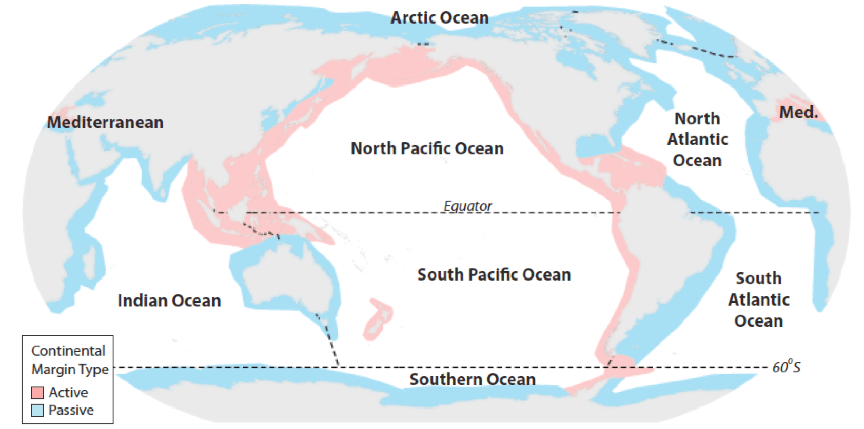
- A continental margin is the outer edge of continental crust abutting oceanic crust under coastal waters. It is one of the three major zones of the ocean floor, the other two being deep-ocean basins and mid-ocean ridges. The continental margin consists of three different features: the continental rise, the continental slope, and the continental shelf. The continental shelf is the relatively shallow water area found in proximity to continents. Continental margins constitute about 28% of the oceanic area. (en)
- Der Kontinentalrand ist der Übergang von einem Kontinent in den ozeanischen Bereich. Die Kontinentalränder sind für die Stratigraphie von besonderer Bedeutung, weil an ihnen oder unmittelbar vor ihnen im Laufe der Erdgeschichte Sedimente abgelagert wurden, die zum Großteil unsere heutigen Abfolgen von Sedimentgesteinen ausmachen. Das gilt auch für das aktuelle geologische Geschehen. (de)
- Kontinente-ertza lurrazal kontinentalaren eta lurrazal ozeanikoaren arteko muga definitzeko erabiltzen den terminoa da. Litosfera kontinentalaren eta litosfera ozeanikoaren arteko muga zehaztea oso zaila da sedimentuz estalia edo guztiz deformatuta dagoelako beraz, ikusten den trantsizioari deritzo kontinente-ertz. Ozeanoetako hondoa osatzen duten hiru zonaldeetako bat da, besteak ozeano gandorrak eta lautada abisalak izanik. Kontinente-ertzen morfologia, ezaugarri tektonikoen arabera lau mota nagusi bereizten dira: , ertz konbergenteak, ertz transformatzaileak eta . (eu)
- La marge continentale est la zone sous-marine située au bord des continents dans laquelle la majeure partie des sédiments issus de l'érosion du continent est transportée. La marge continentale comprend le plateau continental, le talus continental et le glacis continental. Une marge est dite active quand une zone de subduction est présente ou passive, quand la transition entre la croute continentale et la croute océanique est directe. (fr)
- El es una de las tres zonas principales del fondo oceánico, siendo las otras dos las cuencas oceánicas profundas y las dorsales mediooceánicas. El margen continental es el área de aguas poco profundas que se encuentra cerca del continente. El margen continental consta de tres accidentes diferentes: la plataforma continental, el talud continental y la . Los márgenes continentales constituyen aproximadamente el 28% del área oceánica. (es)
- 대륙사면(大陸斜面, continental slope)은 대륙붕이 끝나는 대륙붕단에서 경사가 급해지는 지역으로 수심이 100에서 2,000미터이다. 대륙사면에는 대륙붕에서 시작된 협곡이 발달되어 있으며, 이 협곡을 따라 장기간 계속 흐르는 저탁류에 의해 대륙붕에서 유입된 퇴적물들이 심해저로 이동한다. (ko)
- 大陸斜面(たいりくしゃめん、continental slope)は、海底の地形()の一つで、大陸棚と大洋底(または深海底)の間の急な斜面。ここには海底谷や海底扇状地などが存在する。水深200m〜2440m。 (ja)
- Il margine continentale è la zona del fondale oceanico che separa la sottile crosta oceanica dalla spessa crosta continentale. Insieme, la piattaforma continentale, il pendio continentale e la scarpata continentale (detta anche salita continentale) sono chiamati margine continentale. I margini continentali costituiscono circa il 28% dell'area oceanica. (it)
- De continentale marge (Engels: continental margin) is in de geologie de overgang tussen een continent, bestaande uit dikke continentale korst en een oceaan, bestaande uit dunne oceanische korst. Continentale marges maken ongeveer 28% uit van de oppervlakte van de oceanen. De overgang tussen continentale en oceanische korst ligt normaal gesproken ergens in het buitenste deel van de continentale marge, dat de continentale verheffing wordt genoemd. Landafwaarts gezien ligt buiten de rand van de continentale verheffing de abyssale vlakte van de oceaanbodem. Het gedeelte van het continent dat onder water staat wordt het continentaal plat genoemd. Het gaat meestal vrij plotseling over in de continentale helling. De continentale helling gaat over in de continentale verheffing aan wat de "voet van de helling" genoemd wordt. Ongeveer 20% van het totale oppervlak aan continentale korst op Aarde staat onder water en maakt deel uit van een continentale marge. De buitengrens van de continentale marge is in het VN-Zeerechtverdrag vastgelegd als grens voor territoriale aanspraken van landen (in dit verdrag wordt de continentale marge met continentaal plat aangeduid, de geomorfologische definities zijn echter anders). Dit verdrag is met name belangrijk voor de van offshore grondstoffen. (nl)
- Подво́дная окра́ина материка́ — часть материковой поверхности, расположенная ниже уровня океана. Иными словами — периферические районы дна Мирового океана с геологическим строением и рельефом, которые представляют из себя продолжение надводной части материковой суши. В экономическом отношении подводная окраина материкового побережья является наиболее доступной для освоения частью морской зоны, в её пределах ведется активная разработка полезных ископаемых (нефть, природный газ и т. п.). В соответствии со статьями 1 и 2 Федерального закона № 187-Ф3 «О континентальном шельфе Российской Федерации» от 30 ноября 1995 года подводная окраина материка, на котором располагается Российская Федерация, определяется как продолжение континентального шельфа, включающее в себя его поверхность и недра. Конвенция ООН по морскому праву в статье 76, устанавливает, что «внешняя граница подводной окраины материка» простирается (i) до места, где толщина осадочных пород составляет не менее одного процента расстояния до подножия континентального склона или (ii) на расстояние 60 миль от подножия континентального склона. (ru)
- 大陆坡为向海一侧,从大陆架外缘较陡地下降到深海底的斜坡。展布于所有大陆周缘。大陆坡上界水深多在100~200米之间;下界一般渐变,约在1500~3500米水深处,在邻近海沟地带,下延至更深处。宽约20~100公里,面积2870万平方公里,占全球面积5.6%。 (zh)
|
| dbo:thumbnail
| |
| dbo:wikiPageExternalLink
| |
| dbo:wikiPageID
| |
| dbo:wikiPageLength
|
- 7899 (xsd:nonNegativeInteger)
|
| dbo:wikiPageRevisionID
| |
| dbo:wikiPageWikiLink
| |
| dbp:wikiPageUsesTemplate
| |
| dcterms:subject
| |
| gold:hypernym
| |
| rdf:type
| |
| rdfs:comment
|
- الحافة القارية هي واحدةٌ من ثلاثة مناطق ينقسمُ إليها قاع المحيط (وأما الاثنتان الأخريان فهما أحواض أعماق المحيط وجروف وسط المحيط). والحافة القارية هي إقليم مياه ضحلة يكثرُ قرب سواحل القارات، ولها ثلاثة سمات مميّزة، هي الارتفاع القاري والانحدار القاري والرف القاري. وتؤلّف الحواف القارية 28% من مساحة المحيطات. (ar)
- A continental margin is the outer edge of continental crust abutting oceanic crust under coastal waters. It is one of the three major zones of the ocean floor, the other two being deep-ocean basins and mid-ocean ridges. The continental margin consists of three different features: the continental rise, the continental slope, and the continental shelf. The continental shelf is the relatively shallow water area found in proximity to continents. Continental margins constitute about 28% of the oceanic area. (en)
- Der Kontinentalrand ist der Übergang von einem Kontinent in den ozeanischen Bereich. Die Kontinentalränder sind für die Stratigraphie von besonderer Bedeutung, weil an ihnen oder unmittelbar vor ihnen im Laufe der Erdgeschichte Sedimente abgelagert wurden, die zum Großteil unsere heutigen Abfolgen von Sedimentgesteinen ausmachen. Das gilt auch für das aktuelle geologische Geschehen. (de)
- Kontinente-ertza lurrazal kontinentalaren eta lurrazal ozeanikoaren arteko muga definitzeko erabiltzen den terminoa da. Litosfera kontinentalaren eta litosfera ozeanikoaren arteko muga zehaztea oso zaila da sedimentuz estalia edo guztiz deformatuta dagoelako beraz, ikusten den trantsizioari deritzo kontinente-ertz. Ozeanoetako hondoa osatzen duten hiru zonaldeetako bat da, besteak ozeano gandorrak eta lautada abisalak izanik. Kontinente-ertzen morfologia, ezaugarri tektonikoen arabera lau mota nagusi bereizten dira: , ertz konbergenteak, ertz transformatzaileak eta . (eu)
- La marge continentale est la zone sous-marine située au bord des continents dans laquelle la majeure partie des sédiments issus de l'érosion du continent est transportée. La marge continentale comprend le plateau continental, le talus continental et le glacis continental. Une marge est dite active quand une zone de subduction est présente ou passive, quand la transition entre la croute continentale et la croute océanique est directe. (fr)
- El es una de las tres zonas principales del fondo oceánico, siendo las otras dos las cuencas oceánicas profundas y las dorsales mediooceánicas. El margen continental es el área de aguas poco profundas que se encuentra cerca del continente. El margen continental consta de tres accidentes diferentes: la plataforma continental, el talud continental y la . Los márgenes continentales constituyen aproximadamente el 28% del área oceánica. (es)
- 대륙사면(大陸斜面, continental slope)은 대륙붕이 끝나는 대륙붕단에서 경사가 급해지는 지역으로 수심이 100에서 2,000미터이다. 대륙사면에는 대륙붕에서 시작된 협곡이 발달되어 있으며, 이 협곡을 따라 장기간 계속 흐르는 저탁류에 의해 대륙붕에서 유입된 퇴적물들이 심해저로 이동한다. (ko)
- 大陸斜面(たいりくしゃめん、continental slope)は、海底の地形()の一つで、大陸棚と大洋底(または深海底)の間の急な斜面。ここには海底谷や海底扇状地などが存在する。水深200m〜2440m。 (ja)
- Il margine continentale è la zona del fondale oceanico che separa la sottile crosta oceanica dalla spessa crosta continentale. Insieme, la piattaforma continentale, il pendio continentale e la scarpata continentale (detta anche salita continentale) sono chiamati margine continentale. I margini continentali costituiscono circa il 28% dell'area oceanica. (it)
- 大陆坡为向海一侧,从大陆架外缘较陡地下降到深海底的斜坡。展布于所有大陆周缘。大陆坡上界水深多在100~200米之间;下界一般渐变,约在1500~3500米水深处,在邻近海沟地带,下延至更深处。宽约20~100公里,面积2870万平方公里,占全球面积5.6%。 (zh)
- De continentale marge (Engels: continental margin) is in de geologie de overgang tussen een continent, bestaande uit dikke continentale korst en een oceaan, bestaande uit dunne oceanische korst. Continentale marges maken ongeveer 28% uit van de oppervlakte van de oceanen. (nl)
- Подво́дная окра́ина материка́ — часть материковой поверхности, расположенная ниже уровня океана. Иными словами — периферические районы дна Мирового океана с геологическим строением и рельефом, которые представляют из себя продолжение надводной части материковой суши. В экономическом отношении подводная окраина материкового побережья является наиболее доступной для освоения частью морской зоны, в её пределах ведется активная разработка полезных ископаемых (нефть, природный газ и т. п.). (ru)
|
| rdfs:label
|
- حافة قارية (ar)
- Kontinentalrand (de)
- Margen continental (es)
- Kontinente-ertz (eu)
- Continental margin (en)
- Margine continentale (it)
- Marge continentale (fr)
- 대륙사면 (ko)
- 大陸斜面 (ja)
- Continentale marge (nl)
- Подводная окраина материка (ru)
- 大陆坡 (zh)
|
| rdfs:seeAlso
| |
| owl:sameAs
| |
| prov:wasDerivedFrom
| |
| foaf:depiction
| |
| foaf:isPrimaryTopicOf
| |
| is dbo:wikiPageDisambiguates
of | |
| is dbo:wikiPageRedirects
of | |
| is dbo:wikiPageWikiLink
of | |
| is foaf:primaryTopic
of | |


