| dbo:PopulatedPlace/areaTotal
| |
| dbo:abstract
|
- بيت إمرين هي إحدى القرى التابعة لمدينة نابلس تحيط بها برقة، ياصيد، سبسطية ونصف جبيل ويبلغ عدد سكانها 2,821 نسمة (2007م). كلمة (إمرين) سريانية الأصل بمعنى الشيوخ والأمراء ويصبح معنى الاسم (بيت الشيوخ) تقع هذه القرية إلى الشمال الغربي من مدينة نابلس وتبعد عنها 18 كم، يصل إليها طريق محلي معبد يربطها بالطريق الرئيس. تبلغ مساحة اراضيها 12100 دونم تحيط بأراضيها اراضي قرى جبع، ياصيد، عصيرة الشمالية ونصف جبيل. قدر عدد سكانها عام 1922 حوالي (527) نسمة، وفي عام 1945 حوالي (860) نسمة وفي عام 1967 كان حوالي (1009) نسمة وفي عام 1987 ارتفع إلى (1640) نسمة وفي عام 1996 وصل إلى (1668) نسمة. (ar)
- Beit Imrin —en àrab بيت امرين, Bayt Imrīn— és un vila palestina de la governació de Nablus, a Cisjordània, al nord de la vall del Jordà, 18 kilòmetres al nord-oest de Nablus. Segons l'Oficina Central Palestina d'Estadístiques tenia una població de 2.821 habitants en 2007. Beit Imrin és un poble agrícola que produeix llegums blanques, grans, verdures, olives, raïm, ametlles i figues. Hi ha una escola primària de nies i una escola secundària de nois. També hi ha un centre de salut pública, serveis telefònics i postals. (ca)
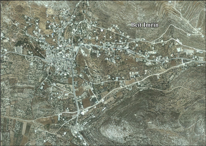
- Beit Imrin (Arabic: بيت امرين, transliterated as "House of Princes") is a Palestinian village in the Nablus Governorate in northern West Bank, located 18 kilometers northwest of Nablus. According to the Palestinian Central Bureau of Statistics (PCBS), the village had a population of 2,821 inhabitants in 2007. Beit Imrin is an agricultural village with the main products being pulses, grains, vegetables, olives, grapes, almonds and figs. There is a girls' primary school and a boys' secondary school in the village. Other public facilities include a health clinic, telephone and postal services. (en)
- Beit Imrin (arabe : بيت امرين, translittéré en anglais "House of Princes"), est un village palestinien dans le gouvernorat de Naplouse. (fr)
|
| dbo:areaTotal
|
- 12100000.000000 (xsd:double)
|
| dbo:country
| |
| dbo:governmentType
| |
| dbo:politicalLeader
| |
| dbo:populationTotal
|
- 2821 (xsd:nonNegativeInteger)
|
| dbo:subdivision
| |
| dbo:thumbnail
| |
| dbo:wikiPageExternalLink
| |
| dbo:wikiPageID
| |
| dbo:wikiPageLength
|
- 14805 (xsd:nonNegativeInteger)
|
| dbo:wikiPageRevisionID
| |
| dbo:wikiPageWikiLink
| |
| dbp:areaTotalDunam
| |
| dbp:areaTotalKm
| |
| dbp:blankInfoSec
|
- "House of Princes", "The House of Imrin" (en)
|
| dbp:blankNameSec
| |
| dbp:establishedTitle
| |
| dbp:governmentType
| |
| dbp:gridName
| |
| dbp:gridPosition
| |
| dbp:imageCaption
|
- Beit Imrin, from the west (en)
|
| dbp:imageSkyline
| |
| dbp:leaderName
| |
| dbp:leaderTitle
|
- Head of Municipality (en)
|
| dbp:name
| |
| dbp:populationAsOf
| |
| dbp:populationDensityKm
| |
| dbp:populationTotal
| |
| dbp:pushpinMap
| |
| dbp:pushpinMapCaption
|
- Location of Beit Imrin within Palestine (en)
|
| dbp:subdivisionName
| |
| dbp:subdivisionType
| |
| dbp:translitLang
| |
| dbp:translitLang1Info
|
- Bayt Umrin (en)
- Beit Imrin (en)
- بيت امرين (en)
|
| dbp:translitLang1Type
| |
| dbp:type
| |
| dbp:unitPref
| |
| dbp:wikiPageUsesTemplate
| |
| dcterms:subject
| |
| gold:hypernym
| |
| georss:point
|
- 32.29222222222222 35.215555555555554
|
| rdf:type
| |
| rdfs:comment
|
- بيت إمرين هي إحدى القرى التابعة لمدينة نابلس تحيط بها برقة، ياصيد، سبسطية ونصف جبيل ويبلغ عدد سكانها 2,821 نسمة (2007م). كلمة (إمرين) سريانية الأصل بمعنى الشيوخ والأمراء ويصبح معنى الاسم (بيت الشيوخ) تقع هذه القرية إلى الشمال الغربي من مدينة نابلس وتبعد عنها 18 كم، يصل إليها طريق محلي معبد يربطها بالطريق الرئيس. تبلغ مساحة اراضيها 12100 دونم تحيط بأراضيها اراضي قرى جبع، ياصيد، عصيرة الشمالية ونصف جبيل. قدر عدد سكانها عام 1922 حوالي (527) نسمة، وفي عام 1945 حوالي (860) نسمة وفي عام 1967 كان حوالي (1009) نسمة وفي عام 1987 ارتفع إلى (1640) نسمة وفي عام 1996 وصل إلى (1668) نسمة. (ar)
- Beit Imrin —en àrab بيت امرين, Bayt Imrīn— és un vila palestina de la governació de Nablus, a Cisjordània, al nord de la vall del Jordà, 18 kilòmetres al nord-oest de Nablus. Segons l'Oficina Central Palestina d'Estadístiques tenia una població de 2.821 habitants en 2007. Beit Imrin és un poble agrícola que produeix llegums blanques, grans, verdures, olives, raïm, ametlles i figues. Hi ha una escola primària de nies i una escola secundària de nois. També hi ha un centre de salut pública, serveis telefònics i postals. (ca)
- Beit Imrin (Arabic: بيت امرين, transliterated as "House of Princes") is a Palestinian village in the Nablus Governorate in northern West Bank, located 18 kilometers northwest of Nablus. According to the Palestinian Central Bureau of Statistics (PCBS), the village had a population of 2,821 inhabitants in 2007. Beit Imrin is an agricultural village with the main products being pulses, grains, vegetables, olives, grapes, almonds and figs. There is a girls' primary school and a boys' secondary school in the village. Other public facilities include a health clinic, telephone and postal services. (en)
- Beit Imrin (arabe : بيت امرين, translittéré en anglais "House of Princes"), est un village palestinien dans le gouvernorat de Naplouse. (fr)
|
| rdfs:label
|
- Beit Imrin (en)
- بيت إمرين (ar)
- Beit Imrin (ca)
- Beit Imrin (fr)
|
| owl:sameAs
| |
| geo:geometry
|
- POINT(35.215557098389 32.292221069336)
|
| geo:lat
| |
| geo:long
| |
| prov:wasDerivedFrom
| |
| foaf:depiction
| |
| foaf:isPrimaryTopicOf
| |
| foaf:name
| |
| is dbo:place
of | |
| is dbo:wikiPageWikiLink
of | |
| is dbp:place
of | |
| is foaf:primaryTopic
of | |


