| dbo:abstract
|
- باقة الحطب قرية فلسطينية في محافظة قلقيلية شمال الضفة الغربية. يبلغ عدد سكانها حوالي 1,943 نسمة حسب التعداد العام للسكان عام 2017. وهي من القرى المحتلة عام النكسة. (ar)
- Baqat al-Hatab (àrab: باقة الحطب, Bāqat al-Ḥaṭab) és una vila palestina de la governació de Qalqilya, a Cisjordània, situada 20 km al sud-oest de Nablus. Segons l'Oficina Central Palestina d'Estadístiques tenia una població de 2.047 habitants el 2016. (ca)
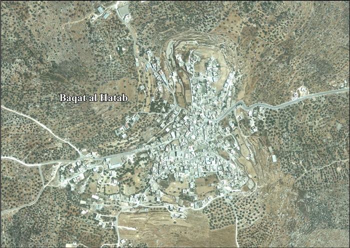
- Baqat al-Hatab (Arabic: باقة الحطب) is a Palestinian village in the Qalqilya Governorate in the western area of the West Bank, located 20 kilometers southwest of Nablus. According to the Palestinian Central Bureau of Statistics, the village had a population of approximately 1,748 inhabitants in 2006. (en)
|
| dbo:country
| |
| dbo:elevation
| |
| dbo:governmentType
| |
| dbo:populationTotal
|
- 1748 (xsd:nonNegativeInteger)
|
| dbo:subdivision
| |
| dbo:thumbnail
| |
| dbo:wikiPageExternalLink
| |
| dbo:wikiPageID
| |
| dbo:wikiPageLength
|
- 10676 (xsd:nonNegativeInteger)
|
| dbo:wikiPageRevisionID
| |
| dbo:wikiPageWikiLink
| |
| dbp:blankInfoSec
|
- Baka, from personal name (en)
|
| dbp:blankNameSec
| |
| dbp:elevationM
| |
| dbp:establishedTitle
| |
| dbp:governmentType
| |
| dbp:gridName
| |
| dbp:gridPosition
| |
| dbp:imageCaption
| |
| dbp:imageSkyline
| |
| dbp:name
| |
| dbp:populationAsOf
| |
| dbp:populationDensityKm
| |
| dbp:populationTotal
| |
| dbp:pushpinMap
| |
| dbp:pushpinMapCaption
|
- Location of Baqat al-Hatab within Palestine (en)
|
| dbp:subdivisionName
| |
| dbp:subdivisionType
| |
| dbp:translitLang
| |
| dbp:translitLang1Info
| |
| dbp:translitLang1Type
| |
| dbp:type
| |
| dbp:unitPref
| |
| dbp:wikiPageUsesTemplate
| |
| dcterms:subject
| |
| gold:hypernym
| |
| georss:point
|
- 32.20472222222222 35.11472222222222
|
| rdf:type
| |
| rdfs:comment
|
- باقة الحطب قرية فلسطينية في محافظة قلقيلية شمال الضفة الغربية. يبلغ عدد سكانها حوالي 1,943 نسمة حسب التعداد العام للسكان عام 2017. وهي من القرى المحتلة عام النكسة. (ar)
- Baqat al-Hatab (àrab: باقة الحطب, Bāqat al-Ḥaṭab) és una vila palestina de la governació de Qalqilya, a Cisjordània, situada 20 km al sud-oest de Nablus. Segons l'Oficina Central Palestina d'Estadístiques tenia una població de 2.047 habitants el 2016. (ca)
- Baqat al-Hatab (Arabic: باقة الحطب) is a Palestinian village in the Qalqilya Governorate in the western area of the West Bank, located 20 kilometers southwest of Nablus. According to the Palestinian Central Bureau of Statistics, the village had a population of approximately 1,748 inhabitants in 2006. (en)
|
| rdfs:label
|
- Baqat al-Hatab (en)
- باقة الحطب (ar)
- Baqat al-Hatab (ca)
|
| owl:sameAs
| |
| geo:geometry
|
- POINT(35.114723205566 32.204723358154)
|
| geo:lat
| |
| geo:long
| |
| prov:wasDerivedFrom
| |
| foaf:depiction
| |
| foaf:isPrimaryTopicOf
| |
| foaf:name
| |
| is dbo:wikiPageRedirects
of | |
| is dbo:wikiPageWikiLink
of | |
| is foaf:primaryTopic
of | |


