| dbo:PopulatedPlace/areaTotal
| |
| dbo:abstract
|
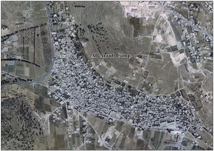
- El camp de refugiats d'Al-Arroub (àrab: مخيّم العروب, muẖayyam al-ʿArrūb) és un camp de refugiats palestí de la governació d'Hebron, a Cisjordània, situat a la , 15 quilòmetres al sud de Betlem, amb una superfície total de 350 dúnams. Des de la Guerra dels Sis Dies, el 1967, el campament ha estat sota l'ocupació israeliana. La població del cens de 1967 realitzada per les autoritats israelianes era de 3.647 habitants. Segons la UNRWA en 2005, tenia una població de 9,859 refugiats registrats. Segons l'Oficina Central Palestina d'Estadístiques tenia una població de 10.487 habitants el 2016. En 2002 es van construir dues escoles al campament: una escola secundària per a nois i una altra per a noies. (ca)
- مخيم العروب هو مخيم فلسطيني يقع شمال مدينة الخليل، معظم سكانه سكنوه بعد النكبة عام 1948م. أُنشئ عام 1949 في منطقة «وادي الصقيع»، على بعد 15 كم إلى الجنوب من مدينة بيت لحم، ويقع على يسار الشارع الرئيسي (بيت لحم ـ الخليل)، ويبعد 35 كم إلى الجنوب من مدينة القدس. يحده من الشمال قرية بيت فجَّار، وعين العروب، ومن الشرق أراضي بلدتي سعير، والشيوخ، ومن الجنوب أراضي بلدة حلحول، ومن الغرب بيت أُمَّر. بلغت مساحة المخيم، عام 1949، حوالي 258 دونماً، تقلصت إلى 238 دونماً. وبلغ عدد السكان حوالي 6775 نسمة حسب إحصاءات 1995، ومعظمهم من القوى العاملة الذين يعملون في قطاع الخدمات، وعمال بالأجرة، في مختلف القطاعات في الضفة. (ar)
- Al-Arroub (Arabic: مخيّم العروب, lit. 'Camp al-'Arrub') is a Palestinian refugee camp located in the southern West Bank along the Hebron-Jerusalem road, in the Hebron Governorate of the State of Palestine. Al-Arroub is 15 kilometers south of Bethlehem, with a total land area of 240 dunums. Since the Six-Day War in 1967, the camp has been under Israeli occupation. The population in the 1967 census conducted by the Israeli authorities was 3,647. According to the UNRWA, in 2005, it had a population of 9,859 registered refugees. According to the Palestinian Central Bureau of Statistics (PCBS), the camp's population is 10,487 in 2016. In 2002, two schools were built in the camp: the Arroup Secondary School for boys, and another school for girls. (en)
- El campamento de al-Arrub (Árabe: مخيّم العروب) es un campo de refugiados palestinos ubicado al sur de Cisjordania (Palestina), junto a la carretera Hebrón-Jerusalén, en la Gobernación de Hebrón. Está a unos 15 kilómetros al sur de Belén. La superficie total del campamento es de 240 dunams (0,24 km²) y según UNRWA, la agencia de las Naciones Unidas responsable de los refugiados palestinos, en 2005 había 9.859 refugiados registrados en el campamento. No obstante, según la Oficina Central de Estadísticas de Palestina, la población del campamento era de 7.941 habitantes en 2007. (es)
- Arroub (en arabe : مخيّم العروب), est un camp de réfugiés palestinien situé au sud de la Cisjordanie, à quinze kilomètres au sud de Bethléem dans le Gouvernorat de Hébron, le long de la route 60 qui relie Hébron à Jérusalem. La superficie du camp est de 350 dunum et comptait 9 859 réfugiés enregistrés auprès de l'UNRWA en 2005. Le Bureau Central Palestinien de Statistique (PCBS) dénombrait 7 941 habitants en 2007. Le camp compte deux écoles, une pour les filles et une pour les garçons. (fr)
- Muchajjam al-Arrub (arab. مخيم العروب) – obóz dla uchodźców palestyńskich w Autonomii Palestyńskiej (południowy Zachodni Brzeg, Hebron). Według danych Palestyńskiego Centralnego Biura Statystycznego w 2016 roku liczył 10 487 mieszkańców. (pl)
|
| dbo:areaTotal
|
- 240000.000000 (xsd:double)
|
| dbo:country
| |
| dbo:governmentType
| |
| dbo:populationTotal
|
- 10487 (xsd:nonNegativeInteger)
|
| dbo:subdivision
| |
| dbo:thumbnail
| |
| dbo:wikiPageExternalLink
| |
| dbo:wikiPageID
| |
| dbo:wikiPageLength
|
- 5455 (xsd:nonNegativeInteger)
|
| dbo:wikiPageRevisionID
| |
| dbo:wikiPageWikiLink
| |
| dbp:areaTotalDunam
| |
| dbp:areaTotalKm
| |
| dbp:establishedTitle
| |
| dbp:governmentType
| |
| dbp:gridName
| |
| dbp:imageCaption
|
- Palestinian demonstrators against occupation in El-Arrub (en)
|
| dbp:imageSkyline
|
- Flickr - Israel Forces - Palestinian demonstrators in El-Arrub .jpg (en)
|
| dbp:name
| |
| dbp:populationAsOf
| |
| dbp:populationDensityKm
| |
| dbp:populationTotal
| |
| dbp:pushpinMap
| |
| dbp:pushpinMapCaption
|
- Location of al-Arroub Camp within Palestine (en)
|
| dbp:subdivisionName
| |
| dbp:subdivisionType
| |
| dbp:translitLang
| |
| dbp:translitLang1Info
|
- (en)
- al-'Arrub (en)
- al-Aroub (en)
|
| dbp:translitLang1Type
| |
| dbp:type
| |
| dbp:unitPref
| |
| dbp:wikiPageUsesTemplate
| |
| dcterms:subject
| |
| gold:hypernym
| |
| georss:point
|
- 31.623105555555554 35.136719444444445
|
| rdf:type
| |
| rdfs:comment
|
- مخيم العروب هو مخيم فلسطيني يقع شمال مدينة الخليل، معظم سكانه سكنوه بعد النكبة عام 1948م. أُنشئ عام 1949 في منطقة «وادي الصقيع»، على بعد 15 كم إلى الجنوب من مدينة بيت لحم، ويقع على يسار الشارع الرئيسي (بيت لحم ـ الخليل)، ويبعد 35 كم إلى الجنوب من مدينة القدس. يحده من الشمال قرية بيت فجَّار، وعين العروب، ومن الشرق أراضي بلدتي سعير، والشيوخ، ومن الجنوب أراضي بلدة حلحول، ومن الغرب بيت أُمَّر. بلغت مساحة المخيم، عام 1949، حوالي 258 دونماً، تقلصت إلى 238 دونماً. وبلغ عدد السكان حوالي 6775 نسمة حسب إحصاءات 1995، ومعظمهم من القوى العاملة الذين يعملون في قطاع الخدمات، وعمال بالأجرة، في مختلف القطاعات في الضفة. (ar)
- El campamento de al-Arrub (Árabe: مخيّم العروب) es un campo de refugiados palestinos ubicado al sur de Cisjordania (Palestina), junto a la carretera Hebrón-Jerusalén, en la Gobernación de Hebrón. Está a unos 15 kilómetros al sur de Belén. La superficie total del campamento es de 240 dunams (0,24 km²) y según UNRWA, la agencia de las Naciones Unidas responsable de los refugiados palestinos, en 2005 había 9.859 refugiados registrados en el campamento. No obstante, según la Oficina Central de Estadísticas de Palestina, la población del campamento era de 7.941 habitantes en 2007. (es)
- Arroub (en arabe : مخيّم العروب), est un camp de réfugiés palestinien situé au sud de la Cisjordanie, à quinze kilomètres au sud de Bethléem dans le Gouvernorat de Hébron, le long de la route 60 qui relie Hébron à Jérusalem. La superficie du camp est de 350 dunum et comptait 9 859 réfugiés enregistrés auprès de l'UNRWA en 2005. Le Bureau Central Palestinien de Statistique (PCBS) dénombrait 7 941 habitants en 2007. Le camp compte deux écoles, une pour les filles et une pour les garçons. (fr)
- Muchajjam al-Arrub (arab. مخيم العروب) – obóz dla uchodźców palestyńskich w Autonomii Palestyńskiej (południowy Zachodni Brzeg, Hebron). Według danych Palestyńskiego Centralnego Biura Statystycznego w 2016 roku liczył 10 487 mieszkańców. (pl)
- El camp de refugiats d'Al-Arroub (àrab: مخيّم العروب, muẖayyam al-ʿArrūb) és un camp de refugiats palestí de la governació d'Hebron, a Cisjordània, situat a la , 15 quilòmetres al sud de Betlem, amb una superfície total de 350 dúnams. (ca)
- Al-Arroub (Arabic: مخيّم العروب, lit. 'Camp al-'Arrub') is a Palestinian refugee camp located in the southern West Bank along the Hebron-Jerusalem road, in the Hebron Governorate of the State of Palestine. Al-Arroub is 15 kilometers south of Bethlehem, with a total land area of 240 dunums. Since the Six-Day War in 1967, the camp has been under Israeli occupation. The population in the 1967 census conducted by the Israeli authorities was 3,647. In 2002, two schools were built in the camp: the Arroup Secondary School for boys, and another school for girls. (en)
|
| rdfs:label
|
- مخيم العروب (ar)
- Camp d'Al-Arroub (ca)
- Al-Arroub (camp) (en)
- Campamento de Al-Arrub (es)
- Al-Arroub (kamp) (in)
- Arroub (fr)
- Muchajjam al-Arrub (pl)
|
| owl:sameAs
| |
| geo:geometry
|
- POINT(35.13671875 31.623106002808)
|
| geo:lat
| |
| geo:long
| |
| prov:wasDerivedFrom
| |
| foaf:depiction
| |
| foaf:isPrimaryTopicOf
| |
| foaf:name
| |
| is dbo:wikiPageRedirects
of | |
| is dbo:wikiPageWikiLink
of | |
| is foaf:primaryTopic
of | |
.jpg?width=300)


.jpg)