| dbo:abstract
|
- الزاكاتون عبارة عن بالوعة مملوءة بالمياه الحرارية تنتمي إلى نظام زاكاتون - وهي مجموعة من السمات الكارستية غير العادية الواقعة في بلدية الداما (Aldama) بالقرب من سييرا دي تاماوليباس(Sierra de Tamaulipas ) في ولاية تاموليباس الشمالية الشرقية بالمكسيك. إنها أعمق بالوعة مملوءة بالمياه معروفة في العالم [متنازع عليه - ناقش] بعمق إجمالي يبلغ 339 مترًا (1112 قدمًا). يبلغ عمق بالوعة الإيطالية 392 مترًا (1،286 قدمًا) وهو أعمق من ذلك (العمق الفعلي غير معروف)، لكن طبيعته ككهف شبه عمودي أو بالوعة ما زالت قيد المناقشة. باستخدام جسمال مستقل، تم قياس الجزء الموجود تحت الماء من زاكاتون بعمق 319 مترًا (1047 قدمًا) (فرق 20 مترًا (66 قدمًا) بين حافة الجرف وسطح الماء إضافةً إلى العمق الكلي). زاكاتون هي البالوعة الوحيدة من بين خمس بواليع موجودة في رانشو لا أزوفروسا التي ليس لديها أي تدفق ملحوظ للمياه. يأتي اسم زاكاتون من جزر عشب الزاكيت العائمة البحرية والتي تتحرك على السطح مع الريح. نتج عن كشط من الجدران الصخرية تحت السطح ما لا يقل عن ثلاث شعب جديدة من البكتيريا. (ar)
- Zacatón estas grupo de kvin dolinoj, aŭ cenotoj, situante en nordorienta parto de Tamaulipas, Meksiko. Ĝi estas la plej profunda dolino de al mondo, kun profundo pli ol 300 m. La 5 dolinoj de la Zacatón-sistemo estas: Zacatón, Caarcol, Verde, La Pilita kaj Azufrosa. La nomo Zacatón venas de la libere flosantaj insuloj. La nomo de Zacatón aperis en la internacia gazetaro en 1994, kiam du mergantoj provis atingi ties bazon, sed unu el ili mortis, la alia atingis profundon de 280 m. Oni planas en marto de 2007 subakciĝon per robotoj en la profundon por analizi la profundajn organismojn. la projekto relaiĝas per apogo de NASA, kiu testas robotojn planitajn al Jupitera luno, Eŭropo. La projekto de NASA kaj la mergoroboto nomiĝas DEPTHX. (eo)
- Zacatón ist der Name einer Doline aus einer Gruppe von fünf verbundenen Dolinen oder Cenoten, die sich im nordöstlichsten Staat Mexikos, Tamaulipas, befinden. Zacatón ist die tiefste bekannte wassergefüllte Doline der Welt mit einer Tiefe von mehr als 300 m. Ihr Durchmesser an der Oberfläche beträgt rund 116 m. Der Name Zacatón erhielt die Doline aufgrund der auf der Wasseroberfläche treibenden grasbewachsenen Inseln, die nur vom Wind bewegt werden. Das Wasser der Doline ist 30 °C warm, sehr mineralienhaltig und riecht leicht nach Schwefel. (de)
- El Zacatón es un pozo lleno de agua termal de México que pertenece al sistema Zacatón, un grupo kárstico de características inusuales formado por cinco dolinas o cenotes interconectados que se encuentra situado en el municipio de Aldama, en la parte suroriental del estado de Tamaulipas. Es la sima llena de agua conocida más profunda del mundo, con una profundidad total de 339 m. (Los 392 m de profundidad del Pozzo Merro, en Italia, la hacen más profunda, pero es más bien una cueva casi vertical que una sima). Usando un robot autónomo, la parte subacuática de Zacatón se ha medido hasta los 319 m de profundidad (una diferencia de 20 m entre el borde del acantilado y la superficie de agua se añade a la profundidad total).Zacatón es la única sima de las cinco localizadas en el Rancho La Azufrosa que tiene un flujo de agua notable. El nombre de Zacatón viene de las islas de zacate (pasto) que flotan libremente y se mueven por la superficie con el viento. De unas raspaduras en las paredes de roca bajo la superficie se obtuvieron al menos 6 nuevos phyla de bacterias. La NASA ha utilizando la dolina como sitio de pruebas para los robots en desarrollo para la futura exploración de la luna joviana Europa. (es)
- Le Zacatón est un cénote qui fait partie d'un groupe de cinq cénotes interconnectés situés au nord-est de l'État de Tamaulipas au Mexique, dans la municipalité d'Aldama. Il est le quatrième plus profond puits noyé au monde en 2017 avec une profondeur totale de 339 mètres. Son nom vient des petites îles flottantes constituées de l'herbe zacate et qui parsème sa surface et qui bouge selon le vent. (fr)
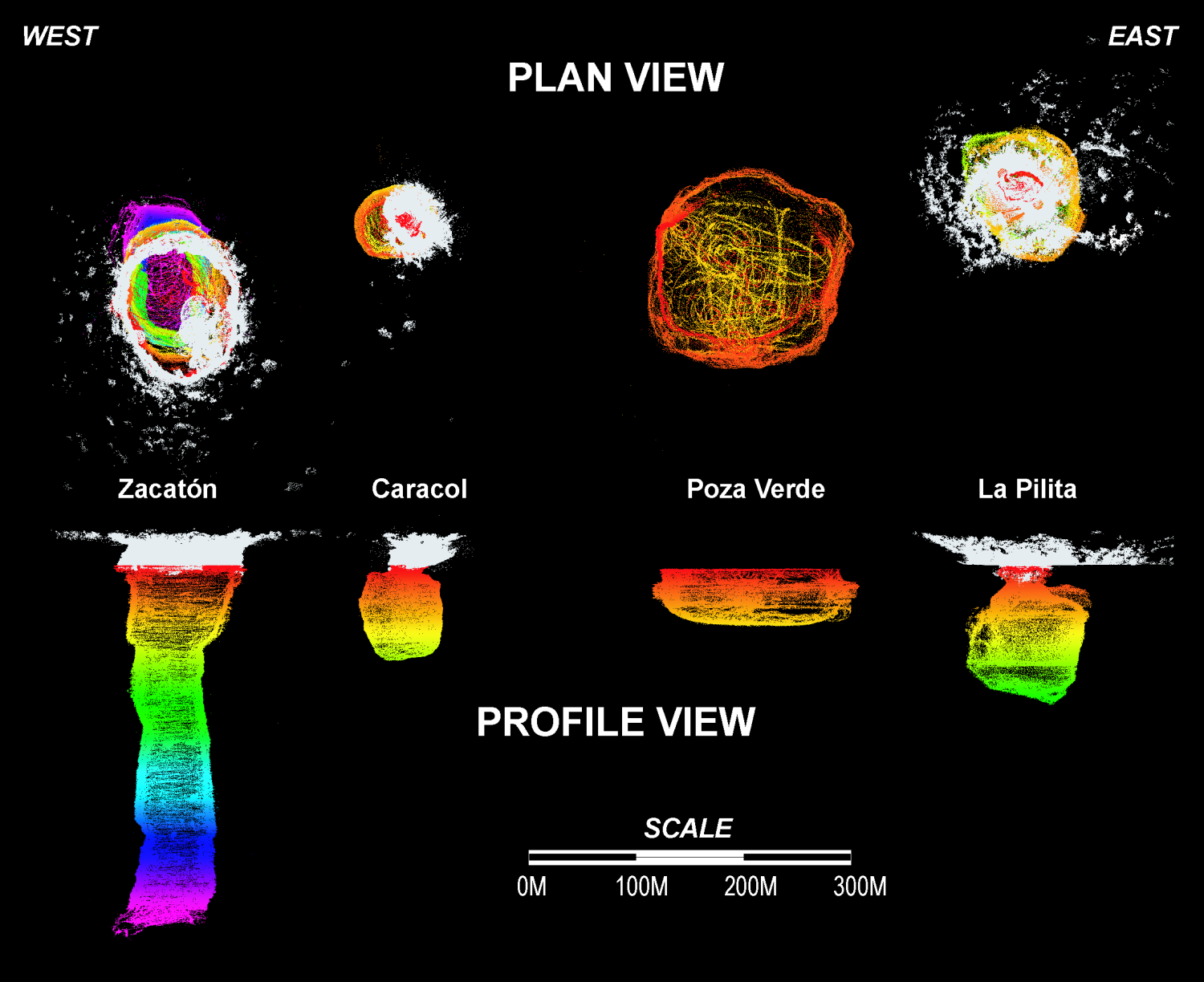
- Zacatón is a cenote (a thermal water-filled sinkhole) belonging to the Zacatón system - a group of unusual karst features located in Aldama Municipality near the Sierra de Tamaulipas in the northeastern state of Tamaulipas, Mexico. It is the deepest known water-filled sinkhole in the world with a total depth of 339 meters (1,112 ft). The 392 meters (1,286 ft) deep Pozzo del Merro is deeper (actual depth unknown), but its nature as a near-vertical cave or a sinkhole still being debated. Using an autonomous robot, the underwater portion of Zacatón has been measured to be 319 meters (1,047 ft) deep (a 20-meter (66 ft) difference between the rim of cliff and surface of water adds to the total depth). Zacatón is the only sinkhole of the five located in Rancho La Azufrosa to have any noticeable water flow. The name Zacatón comes from the free-floating islands of zacate grass which move around on the surface with the wind. Scrapings from the rock walls beneath the surface yielded at least three new phyla of bacteria. (en)
- Сакатон, або ж карстова лійка Ель Сакатон (ісп. Zacatón) — заповнена термальною водою карстова лійка, що належить до системи Сакатон — групи незвичайних карстових об'єктів, розташованих в неподалік від на північному сході штату Тамауліпас, Мексика. Загальна глибина становить 339 метрів, а підводна частина 319 м є найглибшим карстовим озером у світі. (Сант-Анджело-Романо, область Лаціо, Італія) 392 м глибше (глибина поки невідома). За допомогою автономного робота встановлено, що глибина підводної частини Сакатон становить 319 метрів. Сакатон — єдина карстова лійка із п'яти розташованих у Ранчо-Ла-Асуфроса, яка має скільки-небудь помітну витрату води. Назва Сакатон виходить від островків трави сакате, яка вільно плаває по поверхні під дією вітру. Зішкріби зі скельних стін під поверхнею принесли принаймні три нові типи бактерій. (uk)
|
| dbo:thumbnail
| |
| dbo:wikiPageExternalLink
| |
| dbo:wikiPageID
| |
| dbo:wikiPageLength
|
- 10851 (xsd:nonNegativeInteger)
|
| dbo:wikiPageRevisionID
| |
| dbo:wikiPageWikiLink
| |
| dbp:wikiPageUsesTemplate
| |
| dcterms:subject
| |
| gold:hypernym
| |
| georss:point
|
- 22.993347222222223 -98.16586111111111
|
| rdf:type
| |
| rdfs:comment
|
- Zacatón ist der Name einer Doline aus einer Gruppe von fünf verbundenen Dolinen oder Cenoten, die sich im nordöstlichsten Staat Mexikos, Tamaulipas, befinden. Zacatón ist die tiefste bekannte wassergefüllte Doline der Welt mit einer Tiefe von mehr als 300 m. Ihr Durchmesser an der Oberfläche beträgt rund 116 m. Der Name Zacatón erhielt die Doline aufgrund der auf der Wasseroberfläche treibenden grasbewachsenen Inseln, die nur vom Wind bewegt werden. Das Wasser der Doline ist 30 °C warm, sehr mineralienhaltig und riecht leicht nach Schwefel. (de)
- Le Zacatón est un cénote qui fait partie d'un groupe de cinq cénotes interconnectés situés au nord-est de l'État de Tamaulipas au Mexique, dans la municipalité d'Aldama. Il est le quatrième plus profond puits noyé au monde en 2017 avec une profondeur totale de 339 mètres. Son nom vient des petites îles flottantes constituées de l'herbe zacate et qui parsème sa surface et qui bouge selon le vent. (fr)
- الزاكاتون عبارة عن بالوعة مملوءة بالمياه الحرارية تنتمي إلى نظام زاكاتون - وهي مجموعة من السمات الكارستية غير العادية الواقعة في بلدية الداما (Aldama) بالقرب من سييرا دي تاماوليباس(Sierra de Tamaulipas ) في ولاية تاموليباس الشمالية الشرقية بالمكسيك. إنها أعمق بالوعة مملوءة بالمياه معروفة في العالم [متنازع عليه - ناقش] بعمق إجمالي يبلغ 339 مترًا (1112 قدمًا). يبلغ عمق بالوعة الإيطالية 392 مترًا (1،286 قدمًا) وهو أعمق من ذلك (العمق الفعلي غير معروف)، لكن طبيعته ككهف شبه عمودي أو بالوعة ما زالت قيد المناقشة. يأتي اسم زاكاتون من جزر عشب الزاكيت العائمة البحرية والتي تتحرك على السطح مع الريح. (ar)
- Zacatón estas grupo de kvin dolinoj, aŭ cenotoj, situante en nordorienta parto de Tamaulipas, Meksiko. Ĝi estas la plej profunda dolino de al mondo, kun profundo pli ol 300 m. La 5 dolinoj de la Zacatón-sistemo estas: Zacatón, Caarcol, Verde, La Pilita kaj Azufrosa. La nomo Zacatón venas de la libere flosantaj insuloj. La nomo de Zacatón aperis en la internacia gazetaro en 1994, kiam du mergantoj provis atingi ties bazon, sed unu el ili mortis, la alia atingis profundon de 280 m. La projekto de NASA kaj la mergoroboto nomiĝas DEPTHX. (eo)
- El Zacatón es un pozo lleno de agua termal de México que pertenece al sistema Zacatón, un grupo kárstico de características inusuales formado por cinco dolinas o cenotes interconectados que se encuentra situado en el municipio de Aldama, en la parte suroriental del estado de Tamaulipas. Es la sima llena de agua conocida más profunda del mundo, con una profundidad total de 339 m. (Los 392 m de profundidad del Pozzo Merro, en Italia, la hacen más profunda, pero es más bien una cueva casi vertical que una sima). (es)
- Zacatón is a cenote (a thermal water-filled sinkhole) belonging to the Zacatón system - a group of unusual karst features located in Aldama Municipality near the Sierra de Tamaulipas in the northeastern state of Tamaulipas, Mexico. It is the deepest known water-filled sinkhole in the world with a total depth of 339 meters (1,112 ft). The 392 meters (1,286 ft) deep Pozzo del Merro is deeper (actual depth unknown), but its nature as a near-vertical cave or a sinkhole still being debated. Scrapings from the rock walls beneath the surface yielded at least three new phyla of bacteria. (en)
- Сакатон, або ж карстова лійка Ель Сакатон (ісп. Zacatón) — заповнена термальною водою карстова лійка, що належить до системи Сакатон — групи незвичайних карстових об'єктів, розташованих в неподалік від на північному сході штату Тамауліпас, Мексика. Загальна глибина становить 339 метрів, а підводна частина 319 м є найглибшим карстовим озером у світі. (Сант-Анджело-Романо, область Лаціо, Італія) 392 м глибше (глибина поки невідома). Назва Сакатон виходить від островків трави сакате, яка вільно плаває по поверхні під дією вітру. (uk)
|
| rdfs:label
|
- زاكاتون (ar)
- Zacatón (de)
- Zacatón (eo)
- El Zacatón (es)
- Zacatón (fr)
- Zacatón (en)
- Сакатон (uk)
|
| owl:sameAs
| |
| geo:geometry
|
- POINT(-98.165863037109 22.993347167969)
|
| geo:lat
| |
| geo:long
| |
| prov:wasDerivedFrom
| |
| foaf:depiction
| |
| foaf:isPrimaryTopicOf
| |
| is dbo:wikiPageRedirects
of | |
| is dbo:wikiPageWikiLink
of | |
| is foaf:primaryTopic
of | |


