| dbo:PopulatedPlace/areaTotal
| |
| dbo:abstract
|
- طرامة قرية فلسطينية تتبع دورا في محافظة الخليل ، ويحدها من الشرق حدب الفوار ودير رازح ومن الشمال دورا ومن الجنوب وادي الشاجنة ، وهي ترتفع 858 عن سطح البحر ، وبلغ عدد سكانها 631 نسمة عام 2007 (ar)
- Tarrama, també Khirbet al-Tarramah —en àrab طرّامة, Ṭarrāma— és una vila palestina de la governació d'Hebron, a Cisjordània, situada en un turó de 870 metres. Limita al sud amb Dura, al nord amb at-Tabaqa, a l'est amb el camp de Fawwar, a l'oest amb Khursa i al sud amb Deir Razih. La superfície de la vila cobreix 210 dúnams i la vila gaudeix d'electricitat i línies de telèfon. Segons l'Oficina Central Palestina d'Estadístiques tenia una població de 833 habitants el 2016. (ca)
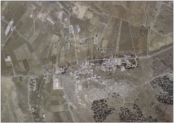
- Tarrama (Arabic: طرّامة, also known as Khirbet al-Tarramah) is a Palestinian village situated on a hilltop with an elevation of 879 meters (2,884 ft) in the southern West Bank, part of the Hebron Governorate. Located just south of Dura, nearby localities include at-Tabaqa to the north, Fawwar to the east, Khursa to the west, and Deir Razih to the south. Its total land area is 210 dunams and the village is provided with electricity and telephone lines. (en)
|
| dbo:areaTotal
|
- 200000.000000 (xsd:double)
|
| dbo:country
| |
| dbo:governmentType
| |
| dbo:populationTotal
|
- 631 (xsd:nonNegativeInteger)
|
| dbo:subdivision
| |
| dbo:wikiPageExternalLink
| |
| dbo:wikiPageID
| |
| dbo:wikiPageLength
|
- 8802 (xsd:nonNegativeInteger)
|
| dbo:wikiPageRevisionID
| |
| dbo:wikiPageWikiLink
| |
| dbp:areaTotalDunam
| |
| dbp:areaTotalKm
| |
| dbp:establishedTitle
| |
| dbp:governmentType
| |
| dbp:gridName
| |
| dbp:gridPosition
| |
| dbp:name
| |
| dbp:populationAsOf
| |
| dbp:populationDensityKm
| |
| dbp:populationTotal
| |
| dbp:pushpinMap
| |
| dbp:pushpinMapCaption
|
- Location of Tarrama within Palestine (en)
|
| dbp:subdivisionName
| |
| dbp:subdivisionType
| |
| dbp:translitLang
| |
| dbp:translitLang1Info
|
- Khirbet al-Tarramah (en)
- طرّامة (en)
|
| dbp:translitLang1Type
| |
| dbp:type
| |
| dbp:unitPref
| |
| dbp:wikiPageUsesTemplate
| |
| dcterms:subject
| |
| gold:hypernym
| |
| georss:point
|
- 31.480833333333333 35.0325
|
| rdf:type
| |
| rdfs:comment
|
- طرامة قرية فلسطينية تتبع دورا في محافظة الخليل ، ويحدها من الشرق حدب الفوار ودير رازح ومن الشمال دورا ومن الجنوب وادي الشاجنة ، وهي ترتفع 858 عن سطح البحر ، وبلغ عدد سكانها 631 نسمة عام 2007 (ar)
- Tarrama, també Khirbet al-Tarramah —en àrab طرّامة, Ṭarrāma— és una vila palestina de la governació d'Hebron, a Cisjordània, situada en un turó de 870 metres. Limita al sud amb Dura, al nord amb at-Tabaqa, a l'est amb el camp de Fawwar, a l'oest amb Khursa i al sud amb Deir Razih. La superfície de la vila cobreix 210 dúnams i la vila gaudeix d'electricitat i línies de telèfon. Segons l'Oficina Central Palestina d'Estadístiques tenia una població de 833 habitants el 2016. (ca)
- Tarrama (Arabic: طرّامة, also known as Khirbet al-Tarramah) is a Palestinian village situated on a hilltop with an elevation of 879 meters (2,884 ft) in the southern West Bank, part of the Hebron Governorate. Located just south of Dura, nearby localities include at-Tabaqa to the north, Fawwar to the east, Khursa to the west, and Deir Razih to the south. Its total land area is 210 dunams and the village is provided with electricity and telephone lines. (en)
|
| rdfs:label
|
- طرامة (ar)
- Tarrama (ca)
- Tarrama (en)
|
| owl:sameAs
| |
| geo:geometry
|
- POINT(35.032501220703 31.480833053589)
|
| geo:lat
| |
| geo:long
| |
| prov:wasDerivedFrom
| |
| foaf:isPrimaryTopicOf
| |
| foaf:name
| |
| is dbo:wikiPageRedirects
of | |
| is dbo:wikiPageWikiLink
of | |
| is foaf:primaryTopic
of | |


