| dbo:abstract
|
- Located directly downstream of the Little Colorado River confluence with the Colorado River, the Tanner Graben, in the Grand Canyon, Arizona, US is a prominence and cliffside rock formation below the East Rim. Tanner Graben is located riverside, on the Colorado River, on a north-northwest bank at Mile 68.5, and lies opposite Tanner Canyon. The , created by Tanner Creek lies at the riverside foot of the graben. The graben is a pronounced feature because of the black Cardenas Basalt that forms the middle section of the graben, presumably free of debris accumulation by its cliff face steepness, and winds, and airflow drainage that course through the Colorado River's canyons; unprotected side canyons of Cardenas Basalt show accumulations as a slope-forming geologic unit, with little showing of black basalt. The Tanner Graben sits on the which trends north-south up the Colorado River, and the west side of Temple Butte; it forms the east flank of Tanner Graben. The Butte Fault is connected to the which trends north-south up the Colorado River, and turns north-northwest forming the east perimeter of the Kaibab Plateau, which lies due-north of the Tanner Graben region. (en)
|
| dbo:city
| |
| dbo:elevation
| |
| dbo:locatedInArea
| |
| dbo:thumbnail
| |
| dbo:type
| |
| dbo:wikiPageExternalLink
| |
| dbo:wikiPageID
| |
| dbo:wikiPageLength
|
- 7786 (xsd:nonNegativeInteger)
|
| dbo:wikiPageRevisionID
| |
| dbo:wikiPageWikiLink
| |
| dbp:city
| |
| dbp:elevationFt
| |
| dbp:elevationRef
| |
| dbp:label
| |
| dbp:labelPosition
| |
| dbp:location
|
- Grand Canyon, Colorado River, Mile 68.5, Desert View, (en)
|
| dbp:mapCaption
| |
| dbp:name
| |
| dbp:photo
|
- Colorado River from Desert View-1000px.jpeg (en)
|
| dbp:photoCaption
|
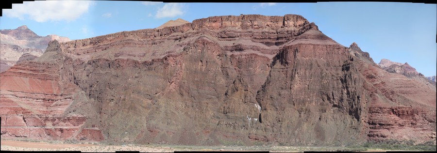
- View north, upriver, Temple and Chuar Buttes, on west bank of Colorado River, East Rim to photo right, and extending to center, top. Black Cardenas Basalt of Tanner Graben, at photo bottom-left, with layered Nankoweap Formation at Tanner Graben prominence. (en)
|
| dbp:photoSize
| |
| dbp:type
|
- Cardenas Basalt & Dox Formation (en)
- Nankoweap Formation-, (en)
|
| dbp:wikiPageUsesTemplate
| |
| dcterms:subject
| |
| gold:hypernym
| |
| georss:point
|
- 36.10388888888889 -111.8338888888889
|
| rdf:type
| |
| rdfs:comment
|
- Located directly downstream of the Little Colorado River confluence with the Colorado River, the Tanner Graben, in the Grand Canyon, Arizona, US is a prominence and cliffside rock formation below the East Rim. Tanner Graben is located riverside, on the Colorado River, on a north-northwest bank at Mile 68.5, and lies opposite Tanner Canyon. The , created by Tanner Creek lies at the riverside foot of the graben. The graben is a pronounced feature because of the black Cardenas Basalt that forms the middle section of the graben, presumably free of debris accumulation by its cliff face steepness, and winds, and airflow drainage that course through the Colorado River's canyons; unprotected side canyons of Cardenas Basalt show accumulations as a slope-forming geologic unit, with little showing of (en)
|
| rdfs:label
| |
| owl:sameAs
| |
| geo:geometry
|
- POINT(-111.83388519287 36.103889465332)
|
| geo:lat
| |
| geo:long
| |
| prov:wasDerivedFrom
| |
| foaf:depiction
| |
| foaf:isPrimaryTopicOf
| |
| foaf:name
| |
| is dbo:wikiPageWikiLink
of | |
| is foaf:primaryTopic
of | |


