| dbo:abstract
|
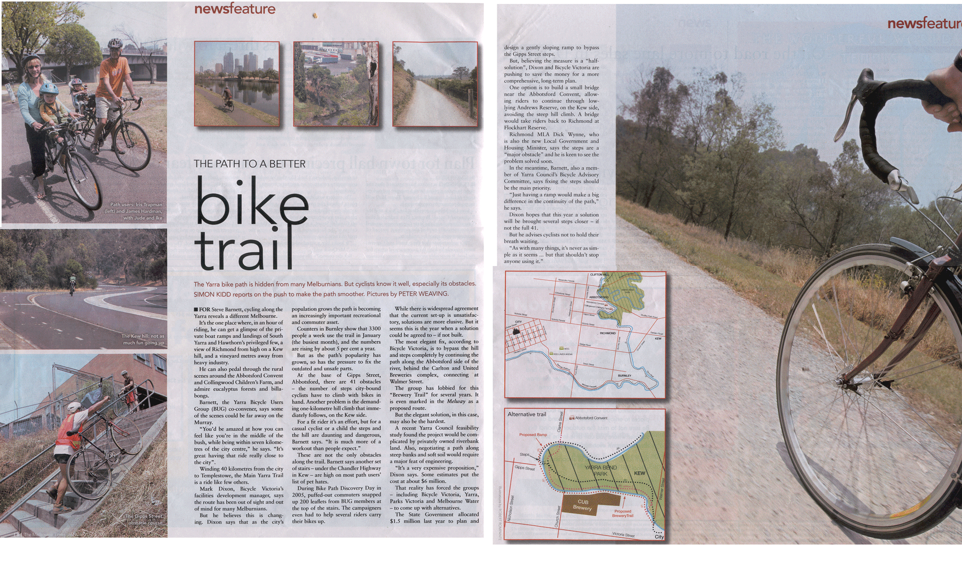
- The Yarra Trail is a shared use path for cyclists and pedestrians, which follows the Yarra River through the north eastern suburbs of Melbourne, Victoria, Australia. The trail follows the river from near its mouth, through the city and suburbs to Westerfolds Park and Eltham. The Capital City Trail uses the same path up to Dights Falls, where it continues up the Merri Creek Trail as part of its loop around the city. Bicycle Victoria has an ongoing campaign to have the path in Yarra Bend Park improved and the stairs at the east end of Gipps Street effectively removed from the trail by continuing the path on the west side of the river. Other alternatives include installing a ramp or installing a new footbridge near the Abbotsford Convent. (en)
|
| dbo:thumbnail
| |
| dbo:wikiPageExternalLink
| |
| dbo:wikiPageID
| |
| dbo:wikiPageLength
|
- 12430 (xsd:nonNegativeInteger)
|
| dbo:wikiPageRevisionID
| |
| dbo:wikiPageWikiLink
|
- dbc:Bike_paths_in_Melbourne
- dbr:Scienceworks_(Melbourne)
- dbr:Mullum_Mullum_Creek_Trail
- dbr:Melbourne_Park
- dbr:Melbourne_Polytechnic
- dbr:Merri_Creek_Trail
- dbc:Yarra_River
- dbr:Richmond,_Victoria
- dbr:Cycling
- dbr:Como_House
- dbr:Crown_Melbourne
- dbr:Melbourne
- dbr:Melbourne_Cricket_Ground
- dbr:Melbourne_central_business_district
- dbr:Outer_Circle_Trail
- dbr:Clifton_Hill_railway_station
- dbr:Eltham,_Victoria
- dbr:Eltham_railway_station,_Melbourne
- dbr:George_Gipps
- dbr:Mullum_Mullum_Creek
- dbr:Confluence
- dbr:MacRobertson_Bridge
- dbr:Collingwood_Children's_Farm
- dbr:Bicycle_Victoria
- dbr:Pedestrian
- dbr:St_Kilda_Beach,_Victoria
- dbr:Burke_Road
- dbr:Darebin_Creek_Trail
- dbr:West_Gate_Bridge
- dbr:Westerfolds_Park
- dbr:Gardiners_Creek_Trail
- dbr:Eastern_Freeway,_Melbourne
- dbr:Abbotsford,_Victoria
- dbr:Fairfield,_Victoria
- dbr:Federation_Square
- dbr:Flinders_Street_railway_station
- dbr:Capital_City_Trail
- dbr:Diamond_Creek_Trail
- dbr:Dights_Falls
- dbr:Koonung_Creek_Trail
- dbr:Heidelberg,_Victoria
- dbr:Heidelberg_railway_station
- dbr:Ivanhoe,_Victoria
- dbr:Chandler_Highway
- dbr:Swanston_Street
- dbr:Hobsons_Bay_Coastal_Trail
- dbr:River_Gum_Walk_Trail
- dbr:Docklands_Highway
- dbc:Heidelberg,_Victoria
- dbr:Southbank,_Victoria
- dbr:Spotswood,_Victoria
- dbr:St_Kilda_Road
- dbr:Templestowe
- dbr:Koori
- dbr:Kulin_Nation
- dbr:Merri_Creek
- dbr:RMIT_University
- dbr:Shared_use_path
- dbr:Wurundjeri
- dbr:Yarra_Bend_Park
- dbr:Yarra_River
- dbr:Yarra_Scenic_Drive
- dbr:Plenty_River_Trail
- dbr:Royal_Botanic_Gardens_Victoria
- dbr:Victoria,_Australia
- dbr:Parklands_adjoining_the_Yarra_River
- dbr:Ruffey_Creek_Trail
- dbr:Princes_Bridge,_Melbourne
- dbr:Port_Phillip_Bay
- dbr:Melbourne_University
- dbr:Lower_Plenty
- dbr:Birrarung_Marr
- dbr:Melbourne_Convention_&_Exhibition_Centre
- dbr:Melbourne_Docklands
- dbr:File:Fairfield_Pipe_Bridge_2009.JPG
- dbr:File:Fairfield_boathouse.jpg
- dbr:File:Topdown_perspective_of_Ruffey_Trail_suspension_bridge.jpg
- dbr:File:Yarra_River_from_Kanes_Bridge.JPG
|
| dbp:caption
|
- The Yarra River, as seen from Kanes Bridge, near the Studley Park boathouse. (en)
|
| dbp:difficulty
| |
| dbp:hazards
|
- Some blind corners, steep drop into river. In winter, on the north bank near the city, ice can form on the floating pontoons. Steep corkscrew path used to cross under Banksia St. (en)
|
| dbp:hills
|
- Gipps Street steps. Bumpy metal joints and slippery ramps on Northbank promenade (en)
|
| dbp:length
|
- About 38km from Princes Bridge to Mullum Mullum Creek Trail (en)
|
| dbp:location
| |
| dbp:name
| |
| dbp:photo
| |
| dbp:surface
|
- Mostly Concrete & bitumen path, well formed gravel along river flats. (en)
|
| dbp:train
|
- Flinders Street, Clifton Hill, Heidelberg and Eltham (en)
|
| dbp:water
|
- Regular water fountains in lower reaches, tap at "Yarra Marsh" (en)
|
| dbp:wikiPageUsesTemplate
| |
| dcterms:subject
| |
| gold:hypernym
| |
| georss:point
| |
| rdf:type
| |
| rdfs:comment
|
- The Yarra Trail is a shared use path for cyclists and pedestrians, which follows the Yarra River through the north eastern suburbs of Melbourne, Victoria, Australia. The trail follows the river from near its mouth, through the city and suburbs to Westerfolds Park and Eltham. The Capital City Trail uses the same path up to Dights Falls, where it continues up the Merri Creek Trail as part of its loop around the city. (en)
|
| rdfs:label
| |
| owl:sameAs
| |
| geo:geometry
|
- POINT(144.90071105957 -37.829303741455)
|
| geo:lat
| |
| geo:long
| |
| prov:wasDerivedFrom
| |
| foaf:depiction
| |
| foaf:isPrimaryTopicOf
| |
| is dbo:wikiPageRedirects
of | |
| is dbo:wikiPageWikiLink
of | |
| is foaf:primaryTopic
of | |


