| dbo:Infrastructure/length
| |
| dbo:abstract
|
- Die Måløybrua (Måløybrücke) ist eine 1224 m lange, als Auslegerbrücke mit insgesamt 32 Stützpfeilern gebaute Straßenbrücke in der Kommune Kinn in der norwegischen Fylke (Provinz) Vestland. (de)
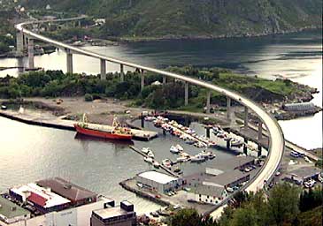
- The Måløy Bridge (Norwegian: Måløybrua) is a cantilever road bridge in Kinn Municipality in Vestland county, Norway. The bridge connects the village area of Degnepoll on the mainland and the town of Måløy on the island of Vågsøy. The bridge carries Norwegian national road 15 over the Måløystraumen strait and Måløy island. The bridge is 1,224 metres (4,016 ft) long, the longest spans are 125 metres (410 ft), and the maximum clearance to the sea is 42 metres (138 ft). In total, the bridge has 34 spans. Construction started in 1971, and it was officially opened by King Olav V on 11 July 1974, although the bridge was actually opened for traffic in December 1973. King Olav came to the opening by ship, returning from a visit to Iceland. The opening of the bridge had to be postponed for a day because the Royal Yacht got delayed by bad weather while at sea. The Måløy Bridge was the longest bridge in Norway at the time of its opening. It cost 32 million kr to construct and was a toll bridge until 1984. The bridge is built to stand wind up to 75 metres per second (170 mph), however vehicles can't stand anything near that. There are boards on each side of the bridge showing the amount of wind, and the bridge has been closed several times because of strong winds. (en)
- A Ponte Måløy (Måløybrua) é uma ponte rodoviária entre o continente e a cidade de sobre Vågsøy, no condado de Sogn og Fjordane, na Noruega. A ponte tem 1224 metros de comprimento, o mais longo vão livre tem 125 metros, e a altura máxima acima do nível do mar é de 42 metros. A ponte tem, no total, 34 colunas. A construção da ponte teve início em 1971. Foi inaugurada oficialmente pelo rei Olavo V em 11 de julho de 1974, embora tenha sido efectivamente aberta para o tráfego em Dezembro de 1973. O rei Olavo chegou à inauguração por navio, vindo de uma visita à Islândia. A abertura da ponte teve que ser adiada por um dia devido ao atraso do navio pelo mau tempo, embora no mar. A Ponte Måløy foi a mais longa ponte da Noruega no momento da sua abertura. Sua construção custou 32 milhões de coroas norueguesas e foi pedagiada até 1984. A ponte foi construída para resistir a ventos até 75 m/s. Existem quadros de cada lado da ponte mostrando a quantidade de energia eólica e, a ponte foi fechada várias vezes por causa do vento muito forte. Quando o vento sopra a partir de um determinado ângulo, pode-se ouvir a ponte a "cantar" (causada pela vibração da ponte e cabos) sobre a nota de C. (pt)
|
| dbo:buildingStartDate
| |
| dbo:length
| |
| dbo:locatedInArea
| |
| dbo:mainspan
| |
| dbo:numberOfSpans
|
- 34 (xsd:nonNegativeInteger)
|
| dbo:openingDate
| |
| dbo:openingYear
|
- 1973-01-01 (xsd:gYear)
- 1974-01-01 (xsd:gYear)
|
| dbo:thumbnail
| |
| dbo:type
| |
| dbo:wikiPageExternalLink
| |
| dbo:wikiPageID
| |
| dbo:wikiPageLength
|
- 3700 (xsd:nonNegativeInteger)
|
| dbo:wikiPageRevisionID
| |
| dbo:wikiPageWikiLink
| |
| dbp:begin
| |
| dbp:caption
| |
| dbp:crosses
| |
| dbp:design
| |
| dbp:fetchwikidata
| |
| dbp:imageSize
| |
| dbp:inaugurated
| |
| dbp:locale
| |
| dbp:name
| |
| dbp:nativeName
| |
| dbp:nativeNameLang
| |
| dbp:open
| |
| dbp:spans
| |
| dbp:wikiPageUsesTemplate
| |
| dcterms:subject
| |
| gold:hypernym
| |
| rdf:type
| |
| rdfs:comment
|
- Die Måløybrua (Måløybrücke) ist eine 1224 m lange, als Auslegerbrücke mit insgesamt 32 Stützpfeilern gebaute Straßenbrücke in der Kommune Kinn in der norwegischen Fylke (Provinz) Vestland. (de)
- The Måløy Bridge (Norwegian: Måløybrua) is a cantilever road bridge in Kinn Municipality in Vestland county, Norway. The bridge connects the village area of Degnepoll on the mainland and the town of Måløy on the island of Vågsøy. The bridge carries Norwegian national road 15 over the Måløystraumen strait and Måløy island. The bridge is 1,224 metres (4,016 ft) long, the longest spans are 125 metres (410 ft), and the maximum clearance to the sea is 42 metres (138 ft). In total, the bridge has 34 spans. (en)
- A Ponte Måløy (Måløybrua) é uma ponte rodoviária entre o continente e a cidade de sobre Vågsøy, no condado de Sogn og Fjordane, na Noruega. A ponte tem 1224 metros de comprimento, o mais longo vão livre tem 125 metros, e a altura máxima acima do nível do mar é de 42 metros. A ponte tem, no total, 34 colunas. A Ponte Måløy foi a mais longa ponte da Noruega no momento da sua abertura. Sua construção custou 32 milhões de coroas norueguesas e foi pedagiada até 1984. (pt)
|
| rdfs:label
|
- Måløybrua (de)
- Måløy Bridge (en)
- Ponte Måløy (pt)
|
| owl:sameAs
| |
| prov:wasDerivedFrom
| |
| foaf:depiction
| |
| foaf:isPrimaryTopicOf
| |
| foaf:name
| |
| is dbo:wikiPageRedirects
of | |
| is dbo:wikiPageWikiLink
of | |
| is foaf:primaryTopic
of | |


