| dbo:PopulatedPlace/areaTotal
| |
| dbo:abstract
|
- Jubbet ad-Dib, també Jubbet adh-Dhib —en àrab جبة الذيب, Jubbat aḏ-Ḏīb— és una vila de la governació de Betlem, al centre de Cisjordània, situada 6,5 kilòmetres al sud-est de Betlem i just a l'est de la vila palestina de Jannatah i al nord de l'assentament israelià de Kfar Eldad. Segons l'Oficina Central d'Estadístiques de Palestina (PCBS), tenia una població de 204 habitants en 2016. Jubbet ad-Dib té una àrea de terra de 402 dúnams, dels quals 8 són sòl edificat, i es troba a 628 metres sobre el nivell del mar. (ca)
- جبة الذيب قرية فلسطينية من قرى الضفة الغربية وتقع في محافظة بيت لحم وقد وقعت تحت الاحتلال الإسرائيلي في حرب 1967 ولكنها تتبع السلطة الوطنية الفلسطينية الآن. ولها مجلس قروي. (ar)
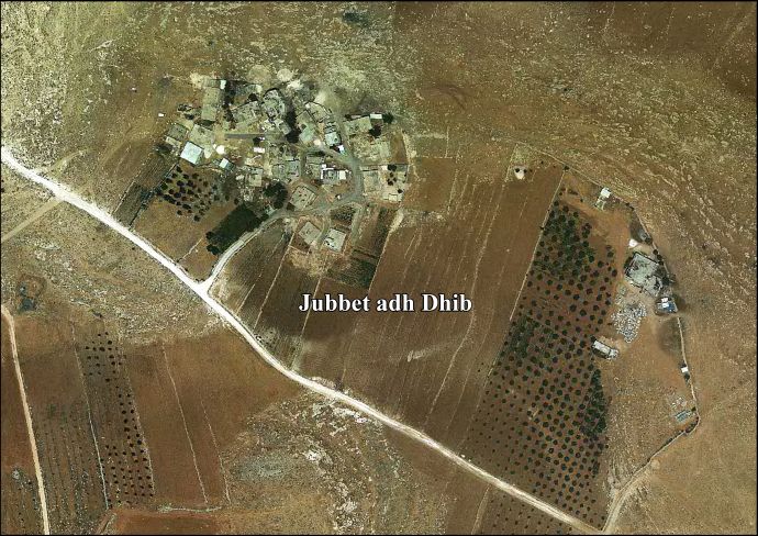
- Jubbet ad-Dib (Arabic: جبة الذيب, also spelled Jubbet adh-Dhib) is a small Palestinian village in the central West Bank, part of the Bethlehem Governorate. It is located about 6.5 kilometers southeast of Bethlehem and is just east of the Palestinian town of Jannatah and north of the Israeli settlement Kfar Eldad. Its lands border on the settlement of Havat Sdeh Bar. It had a population of 162 according to the 2007 census by the Palestinian Central Bureau of Statistics (PCBS). Jubbet ad-Dib has a total land area of 402 dunams, of which 8 constitute as built-up area, and is situated at an altitude of 628 meters above sea level. (en)
|
| dbo:areaTotal
|
- 400000.000000 (xsd:double)
|
| dbo:country
| |
| dbo:governmentType
| |
| dbo:politicalLeader
| |
| dbo:populationTotal
|
- 162 (xsd:nonNegativeInteger)
|
| dbo:subdivision
| |
| dbo:wikiPageExternalLink
| |
| dbo:wikiPageID
| |
| dbo:wikiPageLength
|
- 11876 (xsd:nonNegativeInteger)
|
| dbo:wikiPageRevisionID
| |
| dbo:wikiPageWikiLink
| |
| dbp:areaTotalDunam
| |
| dbp:areaTotalKm
| |
| dbp:blankInfoSec
|
- "the Well of Wolves" (en)
|
| dbp:blankNameSec
| |
| dbp:establishedDate
| |
| dbp:establishedTitle
| |
| dbp:governmentType
| |
| dbp:gridName
| |
| dbp:gridPosition
| |
| dbp:leaderName
| |
| dbp:leaderTitle
|
- Head of Municipality (en)
|
| dbp:name
| |
| dbp:populationAsOf
| |
| dbp:populationDensityKm
| |
| dbp:populationTotal
| |
| dbp:pushpinMap
| |
| dbp:pushpinMapCaption
|
- Location of Jubbet ad-Dib within Palestine (en)
|
| dbp:subdivisionName
| |
| dbp:subdivisionType
| |
| dbp:translitLang
| |
| dbp:translitLang1Info
|
- Jub al-Dib (en)
- Jubbet adh-Dhib (en)
- جبة الذيب (en)
|
| dbp:translitLang1Type
| |
| dbp:type
| |
| dbp:unitPref
| |
| dbp:wikiPageUsesTemplate
| |
| dcterms:subject
| |
| gold:hypernym
| |
| georss:point
|
- 31.681666666666665 35.24194444444444
|
| rdf:type
| |
| rdfs:comment
|
- Jubbet ad-Dib, també Jubbet adh-Dhib —en àrab جبة الذيب, Jubbat aḏ-Ḏīb— és una vila de la governació de Betlem, al centre de Cisjordània, situada 6,5 kilòmetres al sud-est de Betlem i just a l'est de la vila palestina de Jannatah i al nord de l'assentament israelià de Kfar Eldad. Segons l'Oficina Central d'Estadístiques de Palestina (PCBS), tenia una població de 204 habitants en 2016. Jubbet ad-Dib té una àrea de terra de 402 dúnams, dels quals 8 són sòl edificat, i es troba a 628 metres sobre el nivell del mar. (ca)
- جبة الذيب قرية فلسطينية من قرى الضفة الغربية وتقع في محافظة بيت لحم وقد وقعت تحت الاحتلال الإسرائيلي في حرب 1967 ولكنها تتبع السلطة الوطنية الفلسطينية الآن. ولها مجلس قروي. (ar)
- Jubbet ad-Dib (Arabic: جبة الذيب, also spelled Jubbet adh-Dhib) is a small Palestinian village in the central West Bank, part of the Bethlehem Governorate. It is located about 6.5 kilometers southeast of Bethlehem and is just east of the Palestinian town of Jannatah and north of the Israeli settlement Kfar Eldad. Its lands border on the settlement of Havat Sdeh Bar. It had a population of 162 according to the 2007 census by the Palestinian Central Bureau of Statistics (PCBS). Jubbet ad-Dib has a total land area of 402 dunams, of which 8 constitute as built-up area, and is situated at an altitude of 628 meters above sea level. (en)
|
| rdfs:label
|
- جبة الذيب (ar)
- Jubbet ad-Dib (ca)
- Jubbet ad-Dib (en)
|
| owl:sameAs
| |
| geo:geometry
|
- POINT(35.241943359375 31.681667327881)
|
| geo:lat
| |
| geo:long
| |
| prov:wasDerivedFrom
| |
| foaf:isPrimaryTopicOf
| |
| foaf:name
| |
| is dbo:wikiPageRedirects
of | |
| is dbo:wikiPageWikiLink
of | |
| is foaf:primaryTopic
of | |


