| dbo:PopulatedPlace/areaTotal
| |
| dbo:PopulatedPlace/populationDensity
| |
| dbo:abstract
|
- فيرمون (بالإنجليزية: Fermont) هي بلدية محلية في كيبيك تقع في كندا في . يقدر عدد سكانها بـ 2,874 نسمة ومساحتها 495.50 كم2 و وترتفع عن سطح البحر 610 متر. (ar)
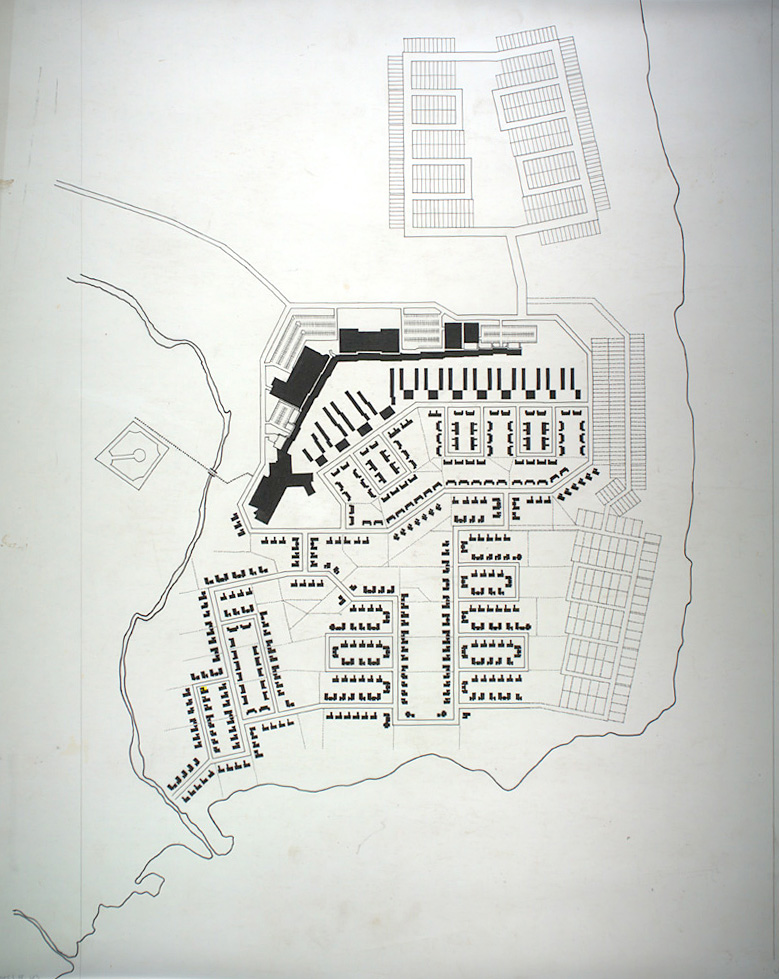
- Fermont ist eine Stadt in der kanadischen Provinz Québec. Die Stadt liegt in der regionalen Grafschaftsgemeinde (municipalité régionale de comté) Caniapiscau und wurde 1955 gegründet, nachdem in der Umgebung Côte-Nord Eisenerzvorkommen entdeckt worden waren. Das in Fermont abgebaute Erz wird auf einer privaten Bahnlinie nach Port-Cartier transportiert, zu Pellets verarbeitet und von dort verschifft. Fermont ist bekannt für ein Gebäude, das weithin als The Wall/Le Mur (engl./franz. „die Mauer“). Das 1,3 Kilometer lange und 15 Meter hohe Gebäude im Norden der Stadt schützt die im Lee liegenden Häuser vor den starken Winden der Gegend. Neben Apartments enthält das Gebäude auch Schulen, Restaurants, Bars, ein Hotel, ein Supermarkt und ein Schwimmbad – sodass die Einwohner während der langen und harten Winter das Gebäude nie verlassen müssen. (de)
- Fermont (/ˈfɛərmɒnt/) is a town in northeastern Quebec, Canada, near the Quebec-Labrador border about 23 kilometres (14 mi) from Labrador City on Route 389, which connects to the Trans-Labrador Highway (Newfoundland and Labrador Route 500). It is the seat of the Regional County Municipality of Caniapiscau. Fermont (French contraction of "Fer Mont", meaning "Iron Mountain") was founded as a company town in the early 1970s to exploit rich iron ore deposits from Mont Wright, which is about 25 kilometres (16 mi) to the west. The town is notable for the huge self-contained structure containing apartments, stores, schools, bars, a hotel, restaurants, a supermarket and swimming pool which shelters a community of smaller apartment buildings and homes on its leeward side. Popularly known as The Wall (Le Mur), the structure was designed to be a windscreen to the rest of the town. It permits residents (other than mine workers) to never leave the building during the long winter, which usually lasts about seven months. The town, designed by Maurice Desnoyers and Norbert Schoenauer, was inspired by similar projects in Sweden designed by Ralph Erskine, notably that of Svappavaara, an iron mining town in Sweden. The building measures 1.3 kilometres (4,300 ft) long and stands 15 metres (49 ft) high. (en)
- Fermont es una ciudad de la provincia de Quebec, Canadá. Está ubicada en el condado regional de Caniapiscau y a su vez, en la región administrativa de Côte-Nord. Forma parte de las circunscripciones electorales de Duplessis a nivel provincial y de Manicouagan a nivel federal. (es)
- Fermont Quebeceko udalerri bat da, Kanadan. Côte-Nord eskualdean kokatuta dago, eta horren barruan dagoen Caniapiscau konderriko eskualde udalerria da..2011ko zentsoaren arabera 2,874 biztanle zituen 470.67 kilometro koadroko azaleran. (eu)
- Fermont est une ville minière située dans la municipalité régionale de comté de Caniapiscau, dans la région administrative de la Côte-Nord, au Québec, au Canada. Fondée en 1974, Fermont comptait au recensement de 2021 une population de 2 256 habitants. (fr)
- Fermont è un comune del Canada di 2.474 abitanti, situato nella provincia del Québec, nella regione di Côte-Nord. (it)
- Fermont – miasto w Kanadzie, w prowincji Quebec, w regionie Côte-Nord i MRC Caniapiscau. Miasto powstało w 1974 roku na potrzeby górników pracujących przy wydobyciu rud żelaza z pobliskiej góry . Nazwa miasta wywodzi się z połączenia francuskich słów: Fer-żelazo Mont-góra. Liczba mieszkańców Fermont wynosi 2 633. Język francuski jest językiem ojczystym dla 96,8%, angielski dla 2,3% mieszkańców (2006). (pl)
- Fermont é uma cidade localizada no nordeste da província de Quebec, no Canadá. Está a 23 quilômetros da fronteira de Quebec com Terra Nova e Labrador, sua população é de 2474 habitantes, no censo de 2016. (pt)
- Fermont är en stad (kommun av typen ville) i provinsen Québec i Kanada. Den ligger i regionen Côte-Nord i norra delen av provinsen vid gränsen till Newfoundland och Labrador. Kommunen hade 2 474 invånare vid folkräkningen 2016, av dem fanns 2 288 i orten Fermont. Orten Fermont domineras av en 15 meter hög och 1,3 km lång byggnad som innehåller nästan 500 lägenheter och viktiga samhällsfunktioner som skola, kommunhus, sportanläggningar och affärer. Byggnaden kallas "Le Mur" och fungerar som skyddsmur mot kalla nordvindar för resten av samhället, inspirerat av Ralph Erskines idéer från Svappavaara. (sv)
|
| dbo:areaCode
| |
| dbo:areaLand
|
- 476890000.000000 (xsd:double)
|
| dbo:areaTotal
|
- 495500000.000000 (xsd:double)
|
| dbo:country
| |
| dbo:elevation
| |
| dbo:foundingDate
| |
| dbo:motto
| |
| dbo:politicalLeader
| |
| dbo:populationDensity
| |
| dbo:populationTotal
|
- 2474 (xsd:nonNegativeInteger)
|
| dbo:postalCode
| |
| dbo:subdivision
| |
| dbo:thumbnail
| |
| dbo:timeZone
| |
| dbo:type
| |
| dbo:utcOffset
| |
| dbo:wikiPageExternalLink
| |
| dbo:wikiPageID
| |
| dbo:wikiPageLength
|
- 24264 (xsd:nonNegativeInteger)
|
| dbo:wikiPageRevisionID
| |
| dbo:wikiPageWikiLink
| |
| dbp:2001AccessDate
| |
| dbp:2001LandArea
| |
| dbp:2001MeanHhIncome
| |
| dbp:2001MedianAge
| |
| dbp:2001MedianAgeF
| |
| dbp:2001MedianAgeM
| |
| dbp:2001PopDelta
| |
| dbp:2001PopDensity
| |
| dbp:2001Population
| |
| dbp:2001TotalPvtDwell
| |
| dbp:2006AccessDate
| |
| dbp:2006LandArea
| |
| dbp:2006MeanHhIncome
| |
| dbp:2006MedianAge
| |
| dbp:2006MedianAgeF
| |
| dbp:2006MedianAgeM
| |
| dbp:2006PopDelta
| |
| dbp:2006PopDensity
| |
| dbp:2006Population
| |
| dbp:2006TotalPvtDwell
| |
| dbp:2011AccessDate
| |
| dbp:2011LandArea
| |
| dbp:2011MeanHhIncome
| |
| dbp:2011MedianAge
| |
| dbp:2011MedianAgeF
| |
| dbp:2011MedianAgeM
| |
| dbp:2011PopDelta
| |
| dbp:2011PopDensity
| |
| dbp:2011Population
| |
| dbp:2011TotalPvtDwell
| |
| dbp:2016AccessDate
| |
| dbp:2016LandArea
| |
| dbp:2016MeanHhIncome
| |
| dbp:2016MedianAge
| |
| dbp:2016MedianAgeF
| |
| dbp:2016MedianAgeM
| |
| dbp:2016PopDelta
| |
| dbp:2016PopDensity
| |
| dbp:2016Population
| |
| dbp:2016TotalPvtDwell
| |
| dbp:2021AccessDate
| |
| dbp:2021Geocode
| |
| dbp:2021LandArea
| |
| dbp:2021MedianAge
| |
| dbp:2021MedianAgeF
| |
| dbp:2021MedianAgeM
| |
| dbp:2021PopDelta
| |
| dbp:2021PopDensity
| |
| dbp:2021Population
| |
| dbp:2021TotalPvtDwell
| |
| dbp:aprHighC
| |
| dbp:aprLowC
| |
| dbp:aprMeanC
| |
| dbp:aprPrecipitationDays
| |
| dbp:aprPrecipitationMm
| |
| dbp:aprRainDays
| |
| dbp:aprRainMm
| |
| dbp:aprRecordHighC
| |
| dbp:aprRecordLowC
| |
| dbp:aprSnowCm
| |
| dbp:aprSnowDays
| |
| dbp:areaCode
| |
| dbp:areaLandKm
| |
| dbp:areaTotalKm
| |
| dbp:augHighC
| |
| dbp:augLowC
| |
| dbp:augMeanC
| |
| dbp:augPrecipitationDays
| |
| dbp:augPrecipitationMm
| |
| dbp:augRainDays
| |
| dbp:augRainMm
| |
| dbp:augRecordHighC
| |
| dbp:augRecordLowC
| |
| dbp:augSnowCm
| |
| dbp:augSnowDays
| |
| dbp:blankName
| |
| dbp:centre
| |
| dbp:date
| |
| dbp:decHighC
| |
| dbp:decLowC
| |
| dbp:decMeanC
| |
| dbp:decPrecipitationDays
| |
| dbp:decPrecipitationMm
| |
| dbp:decRainDays
| |
| dbp:decRainMm
| |
| dbp:decRecordHighC
| |
| dbp:decRecordLowC
| |
| dbp:decSnowCm
| |
| dbp:decSnowDays
| |
| dbp:east
|
- Div. No.10 Subd. D, NL (en)
|
| dbp:elevationM
| |
| dbp:establishedDate
|
- 1971 (xsd:integer)
- 1974-10-15 (xsd:date)
|
| dbp:establishedTitle
|
- Settled (en)
- Constituted (en)
|
| dbp:febHighC
| |
| dbp:febLowC
| |
| dbp:febMeanC
| |
| dbp:febPrecipitationDays
| |
| dbp:febPrecipitationMm
| |
| dbp:febRainDays
| |
| dbp:febRainMm
| |
| dbp:febRecordHighC
| |
| dbp:febRecordLowC
| |
| dbp:febSnowCm
| |
| dbp:febSnowDays
| |
| dbp:imageCaption
|
- Fermont showing windscreen design (en)
|
| dbp:imageShield
|
- Blason ville ca Fermont .svg (en)
|
| dbp:imageSkyline
| |
| dbp:janHighC
| |
| dbp:janLowC
| |
| dbp:janMeanC
| |
| dbp:janPrecipitationDays
| |
| dbp:janPrecipitationMm
| |
| dbp:janRainDays
| |
| dbp:janRainMm
| |
| dbp:janRecordHighC
| |
| dbp:janRecordLowC
| |
| dbp:janSnowCm
| |
| dbp:janSnowDays
| |
| dbp:julHighC
| |
| dbp:julLowC
| |
| dbp:julMeanC
| |
| dbp:julPrecipitationDays
| |
| dbp:julPrecipitationMm
| |
| dbp:julRainDays
| |
| dbp:julRainMm
| |
| dbp:julRecordHighC
| |
| dbp:julRecordLowC
| |
| dbp:julSnowCm
| |
| dbp:julSnowDays
| |
| dbp:junHighC
| |
| dbp:junLowC
| |
| dbp:junMeanC
| |
| dbp:junPrecipitationDays
| |
| dbp:junPrecipitationMm
| |
| dbp:junRainDays
| |
| dbp:junRainMm
| |
| dbp:junRecordHighC
| |
| dbp:junRecordLowC
| |
| dbp:junSnowCm
| |
| dbp:junSnowDays
| |
| dbp:leaderName
| |
| dbp:leaderTitle
| |
| dbp:location
|
- Fermont (en)
- Fermont, Quebec (en)
|
| dbp:mapCaption
|
- Location within Caniapiscau RCM. (en)
|
| dbp:marHighC
| |
| dbp:marLowC
| |
| dbp:marMeanC
| |
| dbp:marPrecipitationDays
| |
| dbp:marPrecipitationMm
| |
| dbp:marRainDays
| |
| dbp:marRainMm
| |
| dbp:marRecordHighC
| |
| dbp:marRecordLowC
| |
| dbp:marSnowCm
| |
| dbp:marSnowDays
| |
| dbp:mayHighC
| |
| dbp:mayLowC
| |
| dbp:mayMeanC
| |
| dbp:mayPrecipitationDays
| |
| dbp:mayPrecipitationMm
| |
| dbp:mayRainDays
| |
| dbp:mayRainMm
| |
| dbp:mayRecordHighC
| |
| dbp:mayRecordLowC
| |
| dbp:maySnowCm
| |
| dbp:maySnowDays
| |
| dbp:metricFirst
| |
| dbp:motto
|
- Faire front, faire face (en)
|
| dbp:name
| |
| dbp:north
|
- Div. No.10 Subd. D, NL (en)
|
| dbp:novHighC
| |
| dbp:novLowC
| |
| dbp:novMeanC
| |
| dbp:novPrecipitationDays
| |
| dbp:novPrecipitationMm
| |
| dbp:novRainDays
| |
| dbp:novRainMm
| |
| dbp:novRecordHighC
| |
| dbp:novRecordLowC
| |
| dbp:novSnowCm
| |
| dbp:novSnowDays
| |
| dbp:octHighC
| |
| dbp:octLowC
| |
| dbp:octMeanC
| |
| dbp:octPrecipitationDays
| |
| dbp:octPrecipitationMm
| |
| dbp:octRainDays
| |
| dbp:octRainMm
| |
| dbp:octRecordHighC
| |
| dbp:octRecordLowC
| |
| dbp:octSnowCm
| |
| dbp:octSnowDays
| |
| dbp:populationAsOf
| |
| dbp:populationBlank
| |
| dbp:populationBlank1Title
| |
| dbp:populationBlank2Title
| |
| dbp:populationDensityKm
| |
| dbp:populationTotal
| |
| dbp:postalCode
| |
| dbp:postalCodeType
| |
| dbp:pushpinLabelPosition
| |
| dbp:pushpinMap
|
- Côte-Nord Region Quebec#Canada Quebec#Canada (en)
|
| dbp:pushpinMapCaption
|
- Location in Côte-Nord Region of Quebec. (en)
|
| dbp:sepHighC
| |
| dbp:sepLowC
| |
| dbp:sepMeanC
| |
| dbp:sepPrecipitationDays
| |
| dbp:sepPrecipitationMm
| |
| dbp:sepRainDays
| |
| dbp:sepRainMm
| |
| dbp:sepRecordHighC
| |
| dbp:sepRecordLowC
| |
| dbp:sepSnowCm
| |
| dbp:sepSnowDays
| |
| dbp:settlementType
| |
| dbp:shieldSize
| |
| dbp:singleLine
| |
| dbp:source
| |
| dbp:south
| |
| dbp:subdivisionName
| |
| dbp:subdivisionType
| |
| dbp:timezone
| |
| dbp:timezoneDst
| |
| dbp:title
|
- Adjacent Municipal Subdivisions (en)
|
| dbp:unitPrecipitationDays
| |
| dbp:unitRainDays
| |
| dbp:unitSnowDays
| |
| dbp:utcOffset
| |
| dbp:utcOffsetDst
| |
| dbp:west
| |
| dbp:wikiPageUsesTemplate
| |
| dbp:yearHighC
| |
| dbp:yearLowC
| |
| dbp:yearMeanC
| |
| dbp:yearPrecipitationMm
| |
| dbp:yearRecordHighC
| |
| dbp:yearRecordLowC
| |
| dcterms:subject
| |
| gold:hypernym
| |
| schema:sameAs
| |
| georss:point
|
- 52.78333333333333 -67.08333333333333
|
| rdf:type
| |
| rdfs:comment
|
- فيرمون (بالإنجليزية: Fermont) هي بلدية محلية في كيبيك تقع في كندا في . يقدر عدد سكانها بـ 2,874 نسمة ومساحتها 495.50 كم2 و وترتفع عن سطح البحر 610 متر. (ar)
- Fermont es una ciudad de la provincia de Quebec, Canadá. Está ubicada en el condado regional de Caniapiscau y a su vez, en la región administrativa de Côte-Nord. Forma parte de las circunscripciones electorales de Duplessis a nivel provincial y de Manicouagan a nivel federal. (es)
- Fermont Quebeceko udalerri bat da, Kanadan. Côte-Nord eskualdean kokatuta dago, eta horren barruan dagoen Caniapiscau konderriko eskualde udalerria da..2011ko zentsoaren arabera 2,874 biztanle zituen 470.67 kilometro koadroko azaleran. (eu)
- Fermont est une ville minière située dans la municipalité régionale de comté de Caniapiscau, dans la région administrative de la Côte-Nord, au Québec, au Canada. Fondée en 1974, Fermont comptait au recensement de 2021 une population de 2 256 habitants. (fr)
- Fermont è un comune del Canada di 2.474 abitanti, situato nella provincia del Québec, nella regione di Côte-Nord. (it)
- Fermont – miasto w Kanadzie, w prowincji Quebec, w regionie Côte-Nord i MRC Caniapiscau. Miasto powstało w 1974 roku na potrzeby górników pracujących przy wydobyciu rud żelaza z pobliskiej góry . Nazwa miasta wywodzi się z połączenia francuskich słów: Fer-żelazo Mont-góra. Liczba mieszkańców Fermont wynosi 2 633. Język francuski jest językiem ojczystym dla 96,8%, angielski dla 2,3% mieszkańców (2006). (pl)
- Fermont é uma cidade localizada no nordeste da província de Quebec, no Canadá. Está a 23 quilômetros da fronteira de Quebec com Terra Nova e Labrador, sua população é de 2474 habitantes, no censo de 2016. (pt)
- Fermont ist eine Stadt in der kanadischen Provinz Québec. Die Stadt liegt in der regionalen Grafschaftsgemeinde (municipalité régionale de comté) Caniapiscau und wurde 1955 gegründet, nachdem in der Umgebung Côte-Nord Eisenerzvorkommen entdeckt worden waren. Das in Fermont abgebaute Erz wird auf einer privaten Bahnlinie nach Port-Cartier transportiert, zu Pellets verarbeitet und von dort verschifft. (de)
- Fermont (/ˈfɛərmɒnt/) is a town in northeastern Quebec, Canada, near the Quebec-Labrador border about 23 kilometres (14 mi) from Labrador City on Route 389, which connects to the Trans-Labrador Highway (Newfoundland and Labrador Route 500). It is the seat of the Regional County Municipality of Caniapiscau. Fermont (French contraction of "Fer Mont", meaning "Iron Mountain") was founded as a company town in the early 1970s to exploit rich iron ore deposits from Mont Wright, which is about 25 kilometres (16 mi) to the west. (en)
- Fermont är en stad (kommun av typen ville) i provinsen Québec i Kanada. Den ligger i regionen Côte-Nord i norra delen av provinsen vid gränsen till Newfoundland och Labrador. Kommunen hade 2 474 invånare vid folkräkningen 2016, av dem fanns 2 288 i orten Fermont. (sv)
|
| rdfs:label
|
- فيرمون (كيبك) (ar)
- Fermont (de)
- Fermont (en)
- Fermont (eo)
- Fermont (es)
- Fermont (Quebec) (eu)
- Fermont (fr)
- Fermont (it)
- Fermont (pl)
- Fermont (Quebec) (pt)
- Fermont (sv)
|
| owl:sameAs
| |
| geo:geometry
|
- POINT(-67.083335876465 52.783332824707)
|
| geo:lat
| |
| geo:long
| |
| prov:wasDerivedFrom
| |
| foaf:depiction
| |
| foaf:homepage
| |
| foaf:isPrimaryTopicOf
| |
| foaf:name
| |
| is dbo:nearestCity
of | |
| is dbo:wikiPageRedirects
of | |
| is dbo:wikiPageWikiLink
of | |
| is dbp:city
of | |
| is dbp:demoCsd
of | |
| is foaf:primaryTopic
of | |
_2.jpg?width=300)


.svg)
_2.jpg)