| dbo:abstract
|
- Das Atlantis-Massiv ist ein unterseeisches Bergmassiv, das sich im Atlantischen Ozean bei etwa 30° Nord und 42° West befindet. Das Massiv erreicht eine Höhe von etwa 3.000 Metern über dem Ozeanboden. Sein Name leitet sich von der Möglichkeit ab, dass die Gipfel des Massivs wohl vor einigen hunderttausend Jahren über die Meeresoberfläche ragten, bevor sie um etwa 700 Meter unter die Meeresoberfläche absackten (siehe dazu auch den Artikel über die antike Sage um das mythische Inselreich Atlantis). Besondere Bekanntheit erlangte das Massiv im Jahre 2000, als bei Forschungstauchfahrten durch das Tiefsee-U-Boot Alvin (DSV-2) zahlreiche hydrothermale geologische Schlote entdeckt wurden. Der Besatzung von Alvin um die Forscherin (University of Washington, Seattle) bot sich der Anblick von Gruppen aus hohen weißen Zinnen und Säulen, die nahezu wie die Reste einer versunkenen Stadt wirkten. Diese bis zu Dutzenden von Metern hohen Türme bestehen aus kristallisierten Mineralien, die entstehen, wenn heißes Quellwasser auf das kalte Wasser der Tiefsee trifft. Dieses heiße Quellwasser tritt vermutlich bereits seit etwa 30.000 Jahren im Atlantis-Massiv aus. Das Gebiet wurde in Anlehnung an den Mythos von Atlantis Lost City (auf deutsch „Verlorene Stadt“) benannt. (de)
- The Atlantis Massif is a prominent undersea massif in the North Atlantic Ocean. It is a dome-shaped region approximately 10 miles (16 km) across and rising about 14,000 feet (4,267 m) from the sea floor. It is located at approximately 30°8′N latitude 42°8′W longitude; just east of the intersection of the Mid-Atlantic Ridge with the Atlantis Transform Fault. The highest point of the massif is around 700 metres (2,297 ft) beneath the surface. (en)
- El Macizo de Atlantis es un macizo submarino de gran tamaño en el Océano Atlántico Norte. Consisten en una región en forma de cúpula de aproximadamente 10 millas (16 km) de ancho y elevándose unos 14 000 pies (4267 m) del fondo del mar. Se encuentra aproximadamente a 30°8′N de latitud 42°8′W de longitud; justo al Este de la intersección de la dorsal mesoatlántica con la falla transformante de Atlantis. El punto más alto del macizo ronda los 700 metros (2297 pies) por debajo de la superficie del mar. Contiene el campo hidrotermal Ciudad Perdida. (es)
- Le massif Atlantis est un massif de montagnes océaniques au milieu de l'océan Atlantique nord. Il s'élève de plus de 4 000 mètres au-dessus du plancher océanique. On y trouve de hautes cheminées volcaniques blanches, notamment au sommet du point culminant baptisé Lost City ou . Une équipe de chercheurs français y a découvert en 2018 la présence de tryptophane à haute température. (fr)
- O Maciço Atlantis é um maciço submarino proeminente, uma região em forma de domo com aproximadamente 16 km de diâmetro, e erguendo-se até 4250 m do fundo do Oceano Atlântico Norte aproximadamente na latitude 30°N, ao leste da interseção entre a dorsal meso-atlântica com a falha transformante Atlantis. O maciço se formou aproximadamente entre 1.5-2.0 milhões de anos atrás. Os estudos geológicos do maciço indicaram que ele não é composto por basalto negro típico do assoalho de oceano, mas do peridotito verde denso encontrado geralmente no manto. A abóbada central é enrrugada e estriada de uma forma indicativa dum complexo nuclear ultramáfico exposto. Acredita-se que o maciço se formou debaixo dorsal meso-atlântica próxima mas foi puxado para debaixo do cume durante o movimento das placas tectônicas. O campo hidrotermal da Cidade Perdida está perto do cume. (pt)
|
| dbo:thumbnail
| |
| dbo:wikiPageExternalLink
| |
| dbo:wikiPageID
| |
| dbo:wikiPageLength
|
- 3872 (xsd:nonNegativeInteger)
|
| dbo:wikiPageRevisionID
| |
| dbo:wikiPageWikiLink
| |
| dbp:age
| |
| dbp:discovered
| |
| dbp:firstVisit
| |
| dbp:location
|
- North Atlantic Ocean (en)
|
| dbp:mapCaption
|
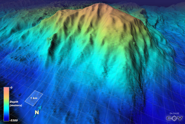
- Undersea topography of the Atlantis Massif highlighting the location of the Lost City Hydrothermal Field (en)
|
| dbp:name
| |
| dbp:photo
|
- Expl2236 - Flickr - NOAA Photo Library.jpg (en)
|
| dbp:photoCaption
|
- The seafloor of the Atlantis Massif, showing white corals and an apparent spotted fish (en)
|
| dbp:type
| |
| dbp:volcanicGroup
| |
| dbp:wikiPageUsesTemplate
| |
| dcterms:subject
| |
| gold:hypernym
| |
| georss:point
| |
| rdf:type
| |
| rdfs:comment
|
- The Atlantis Massif is a prominent undersea massif in the North Atlantic Ocean. It is a dome-shaped region approximately 10 miles (16 km) across and rising about 14,000 feet (4,267 m) from the sea floor. It is located at approximately 30°8′N latitude 42°8′W longitude; just east of the intersection of the Mid-Atlantic Ridge with the Atlantis Transform Fault. The highest point of the massif is around 700 metres (2,297 ft) beneath the surface. (en)
- El Macizo de Atlantis es un macizo submarino de gran tamaño en el Océano Atlántico Norte. Consisten en una región en forma de cúpula de aproximadamente 10 millas (16 km) de ancho y elevándose unos 14 000 pies (4267 m) del fondo del mar. Se encuentra aproximadamente a 30°8′N de latitud 42°8′W de longitud; justo al Este de la intersección de la dorsal mesoatlántica con la falla transformante de Atlantis. El punto más alto del macizo ronda los 700 metros (2297 pies) por debajo de la superficie del mar. Contiene el campo hidrotermal Ciudad Perdida. (es)
- Le massif Atlantis est un massif de montagnes océaniques au milieu de l'océan Atlantique nord. Il s'élève de plus de 4 000 mètres au-dessus du plancher océanique. On y trouve de hautes cheminées volcaniques blanches, notamment au sommet du point culminant baptisé Lost City ou . Une équipe de chercheurs français y a découvert en 2018 la présence de tryptophane à haute température. (fr)
- Das Atlantis-Massiv ist ein unterseeisches Bergmassiv, das sich im Atlantischen Ozean bei etwa 30° Nord und 42° West befindet. Das Massiv erreicht eine Höhe von etwa 3.000 Metern über dem Ozeanboden. Sein Name leitet sich von der Möglichkeit ab, dass die Gipfel des Massivs wohl vor einigen hunderttausend Jahren über die Meeresoberfläche ragten, bevor sie um etwa 700 Meter unter die Meeresoberfläche absackten (siehe dazu auch den Artikel über die antike Sage um das mythische Inselreich Atlantis). (de)
- O Maciço Atlantis é um maciço submarino proeminente, uma região em forma de domo com aproximadamente 16 km de diâmetro, e erguendo-se até 4250 m do fundo do Oceano Atlântico Norte aproximadamente na latitude 30°N, ao leste da interseção entre a dorsal meso-atlântica com a falha transformante Atlantis. O campo hidrotermal da Cidade Perdida está perto do cume. (pt)
|
| rdfs:label
|
- Atlantis Massif (en)
- Atlantis-Massiv (de)
- Macizo de Atlantis (es)
- Massif Atlantis (fr)
- Maciço Atlantis (pt)
|
| owl:sameAs
| |
| geo:geometry
|
- POINT(-42.130001068115 30.129999160767)
|
| geo:lat
| |
| geo:long
| |
| prov:wasDerivedFrom
| |
| foaf:depiction
| |
| foaf:isPrimaryTopicOf
| |
| is dbo:wikiPageDisambiguates
of | |
| is dbo:wikiPageWikiLink
of | |
| is foaf:primaryTopic
of | |


