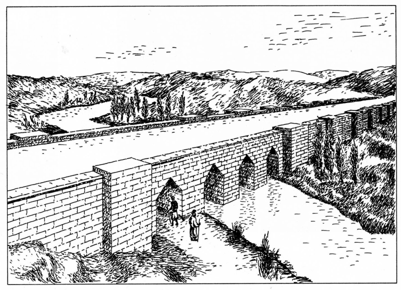
Jerwan is a locality north of Mosul in the Nineveh Province of Iraq. The site is clear of vegetation and is sparsely settled. The site is famous for the ruins of an enormous aqueduct crossing the Khenis River, constructed of more than two million dressed stones and using stone arches and waterproof cement. Some consider it to be the world's oldest aqueduct, predating anything the Romans built by five centuries.
| Attributes | Values |
|---|
| rdf:type
| |
| rdfs:label
| - جروانة (ar)
- Jerwan (en)
- Jerwan (fr)
- ジャーワン (ja)
|
| rdfs:comment
| - Jerwan is a locality north of Mosul in the Nineveh Province of Iraq. The site is clear of vegetation and is sparsely settled. The site is famous for the ruins of an enormous aqueduct crossing the Khenis River, constructed of more than two million dressed stones and using stone arches and waterproof cement. Some consider it to be the world's oldest aqueduct, predating anything the Romans built by five centuries. (en)
- Jerwan est une localité au nord de Mossoul dans la Province de Duhok au Kurdistan irakien. Le site est dépourvu de végétation et peu peuplé. Le site est célèbre pour les ruines d'un immense aqueduc traversant la rivière , composé de plus de deux millions de pierres de taille et utilisant des arches de pierre et un mortier imperméable à l'eau. Certains le considèrent comme l'aqueduc le plus ancien du monde, antérieur de cinq siècles à tout ce que l'Empire romain a pu construire. (fr)
- ジャーワン(Jerwan)は、イラクのニーナワー県にあるモースル北部の一区域である。区域に植物はなく、人もほぼ住んでいない。その場所は、(Khenis River)を渡る巨大な水路の遺跡で有名である。水道橋は、飾りを施した石200万個以上を用いてアーチ構造で築かれ、セメントで防水されていた。ローマが作った水道橋よりも5世紀は遡るもので、世界最古の水道橋と考える学者もいる。 (ja)
- جروانة قرية صغيرة تقع في شمال شرقي الموصل في العراق ، تتبع لـ قضاء الشيخان في محافظة نينوى. تبعد عن عين سفني مسيرة نصف ساعة. تشتهر القرية بوجود قنطرة جروانة وهو مشروع ري كبير بناه الملك الآشوري سنحاريب عام 690 قبل الميلاد، وتقوم بقاياه اليوم عند قرية جروانة 40 كم شمال الموصل، و 3 كم جنوب شرق عين سفني وعمل من خلاله على إيصال الماء سيحا إلى عاصمته نينوى من جبال بافيان شمال العراق عبر قنوات أجراها من أحد روافد نهر الزاب الأعلى وغذّى بها نهر الخوصر الذي يخترق نينوى، وما هذه القنطرة إلا لربط الأودية التي تعترض هذه القنوات وتؤمّن تدفق المياه باتجاه العاصمة الآشورية وقصورها وبساتينها طوال السنة رغم وقوع المدينة على نهر دجلة المنخفض المناسيب. (ar)
|
| name
| |
| geo:lat
| |
| geo:long
| |
| foaf:depiction
| |
| dcterms:subject
| |
| Wikipage page ID
| |
| Wikipage revision ID
| |
| Link from a Wikipage to another Wikipage
| |
| Link from a Wikipage to an external page
| |
| sameAs
| |
| dbp:wikiPageUsesTemplate
| |
| thumbnail
| |
| location
| |
| map type
| |
| georss:point
| - 36.66972222222222 43.39361111111111
|
| has abstract
| - جروانة قرية صغيرة تقع في شمال شرقي الموصل في العراق ، تتبع لـ قضاء الشيخان في محافظة نينوى. تبعد عن عين سفني مسيرة نصف ساعة. تشتهر القرية بوجود قنطرة جروانة وهو مشروع ري كبير بناه الملك الآشوري سنحاريب عام 690 قبل الميلاد، وتقوم بقاياه اليوم عند قرية جروانة 40 كم شمال الموصل، و 3 كم جنوب شرق عين سفني وعمل من خلاله على إيصال الماء سيحا إلى عاصمته نينوى من جبال بافيان شمال العراق عبر قنوات أجراها من أحد روافد نهر الزاب الأعلى وغذّى بها نهر الخوصر الذي يخترق نينوى، وما هذه القنطرة إلا لربط الأودية التي تعترض هذه القنوات وتؤمّن تدفق المياه باتجاه العاصمة الآشورية وقصورها وبساتينها طوال السنة رغم وقوع المدينة على نهر دجلة المنخفض المناسيب. أول اكتشاف للمنطقة الأثرية كان من قبل القنصل الفرنسي في الموصل سنة 1850، ونجح الملك سنحاريب من خلال هذا المشروع بإيصال المياه إلى نينوى في كل المواسم عن طريق نهر الخوصر الذي يجري في موسم الصيهود (موسم الحر وجفاف نهري دجلة والفرات).يبلغ طول عبارة جروانة المائية عند بنائها 280 متر وارتفاعها 9 أمتار وعرضها 20 متر، تتخلها 13 فتحة لتصريف المياه ويبلغ عدد الأحجار المستخدمة مليوني حجر ووزن الواحد منها يبلغ بين 250 إلى 500 كغم، وتقول المصادر التاريخية أن سنحاريب أقام بحيرة كبيرة للاستفادة من المياه الفائضة عن هذه القناة في السقي والزراعة . (ar)
- Jerwan is a locality north of Mosul in the Nineveh Province of Iraq. The site is clear of vegetation and is sparsely settled. The site is famous for the ruins of an enormous aqueduct crossing the Khenis River, constructed of more than two million dressed stones and using stone arches and waterproof cement. Some consider it to be the world's oldest aqueduct, predating anything the Romans built by five centuries. (en)
- Jerwan est une localité au nord de Mossoul dans la Province de Duhok au Kurdistan irakien. Le site est dépourvu de végétation et peu peuplé. Le site est célèbre pour les ruines d'un immense aqueduc traversant la rivière , composé de plus de deux millions de pierres de taille et utilisant des arches de pierre et un mortier imperméable à l'eau. Certains le considèrent comme l'aqueduc le plus ancien du monde, antérieur de cinq siècles à tout ce que l'Empire romain a pu construire. (fr)
- ジャーワン(Jerwan)は、イラクのニーナワー県にあるモースル北部の一区域である。区域に植物はなく、人もほぼ住んでいない。その場所は、(Khenis River)を渡る巨大な水路の遺跡で有名である。水道橋は、飾りを施した石200万個以上を用いてアーチ構造で築かれ、セメントで防水されていた。ローマが作った水道橋よりも5世紀は遡るもので、世界最古の水道橋と考える学者もいる。 (ja)
|
| gold:hypernym
| |
| prov:wasDerivedFrom
| |
| page length (characters) of wiki page
| |
| foaf:isPrimaryTopicOf
| |
| geo:geometry
| - POINT(43.393611907959 36.669723510742)
|

![http://dbpedia.org/describe/?url=http%3A%2F%2Fdbpedia.org%2Fresource%2FJerwan]()


![[RDF Data]](/fct/images/sw-rdf-blue.png)


![[RDF Data]](/fct/images/sw-rdf-blue.png)


![[cxml]](/fct/images/cxml_doc.png)
![[csv]](/fct/images/csv_doc.png)
![[text]](/fct/images/ntriples_doc.png)
![[turtle]](/fct/images/n3turtle_doc.png)
![[ld+json]](/fct/images/jsonld_doc.png)
![[rdf+json]](/fct/images/json_doc.png)
![[rdf+xml]](/fct/images/xml_doc.png)
![[atom+xml]](/fct/images/atom_doc.png)
![[html]](/fct/images/html_doc.png)