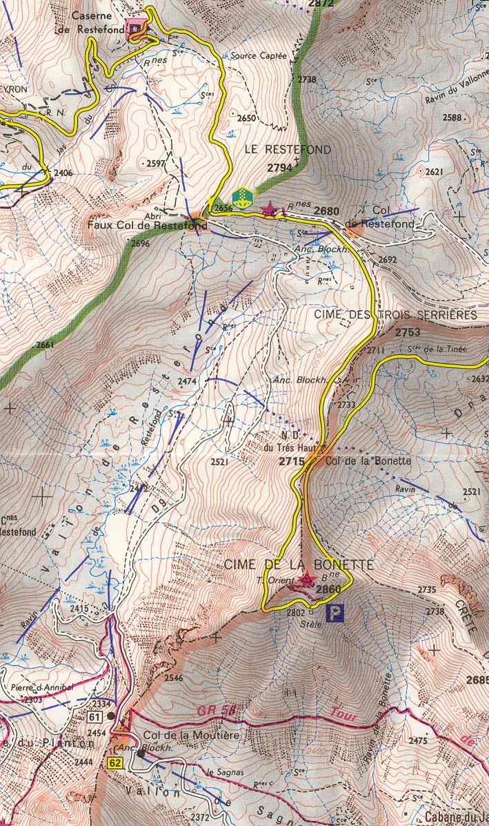
Cime de la Bonette (el. 2,860 metres or 9,383 feet) is a mountain in the French Alps, near the border with Italy. It is situated within the Mercantour National Park on the border of the departments of Alpes-Maritimes and Alpes-de-Haute-Provence, between the Ubaye Valley and the valley of the Tinée River. "Cime" means "summit" in French. The summit is surrounded by road from the Col de la Bonette, which reaches 2,802 metres (9,193 ft), and is the second highest paved through route in the Alps. It is also the highest point reached by the Tour de France.
| Attributes | Values |
|---|
| rdf:type
| |
| rdfs:label
| - Cime de la Bonette (en)
- Cima della Bonette (it)
- Cime de la Bonette (fr)
|
| rdfs:comment
| - Cime de la Bonette (el. 2,860 metres or 9,383 feet) is a mountain in the French Alps, near the border with Italy. It is situated within the Mercantour National Park on the border of the departments of Alpes-Maritimes and Alpes-de-Haute-Provence, between the Ubaye Valley and the valley of the Tinée River. "Cime" means "summit" in French. The summit is surrounded by road from the Col de la Bonette, which reaches 2,802 metres (9,193 ft), and is the second highest paved through route in the Alps. It is also the highest point reached by the Tour de France. (en)
- La Cima della Bonette (Cime de la Bonette in francese) è una montagna delle Alpi alta 2860 m s.l.m., situata nelle Alpi Occidentali (Alpi Marittime) in Francia. Il periplo della sua sommità è percorso da una delle strade più alte d'Europa che raggiunge i 2802 m s.l.m.. (it)
- La cime de la Bonette est un sommet situé au sein du massif du Mercantour-Argentera, entre les Alpes-de-Haute-Provence et les Alpes-Maritimes, dominant au nord la vallée de l'Ubaye et au sud la Tinée. La cime, entourée par la route de la Bonette qui atteint 2 802 mètres d'altitude, est la route goudronnée la plus haute de France. Cette route part du col de la Bonette. À partir du sommet de cette route, un petit sentier pédestre permet de monter à la cime de la montagne à 2 860 mètres. Le sommet, qui permet d'apprécier un large panorama, est doté d'une table d'orientation et d'une table d'explication de la géologie. La cime de la Bonette réserve notamment un point de vue exceptionnel sur le mont Viso. (fr)
|
| foaf:name
| |
| name
| |
| geo:lat
| |
| geo:long
| |
| foaf:depiction
| |
| dcterms:subject
| |
| Wikipage page ID
| |
| Wikipage revision ID
| |
| Link from a Wikipage to another Wikipage
| |
| Link from a Wikipage to an external page
| |
| sameAs
| |
| dbp:wikiPageUsesTemplate
| |
| thumbnail
| |
| elevation m
| |
| label position
| |
| location
| |
| photo
| |
| photo caption
| - Cime de la Bonette, viewed from the northern ascent of the Col de la Bonette pass from Jausiers (en)
|
| range
| |
| georss:point
| - 44.321666666666665 6.8069444444444445
|
| has abstract
| - Cime de la Bonette (el. 2,860 metres or 9,383 feet) is a mountain in the French Alps, near the border with Italy. It is situated within the Mercantour National Park on the border of the departments of Alpes-Maritimes and Alpes-de-Haute-Provence, between the Ubaye Valley and the valley of the Tinée River. "Cime" means "summit" in French. The summit is surrounded by road from the Col de la Bonette, which reaches 2,802 metres (9,193 ft), and is the second highest paved through route in the Alps. It is also the highest point reached by the Tour de France. (en)
- La cime de la Bonette est un sommet situé au sein du massif du Mercantour-Argentera, entre les Alpes-de-Haute-Provence et les Alpes-Maritimes, dominant au nord la vallée de l'Ubaye et au sud la Tinée. La cime, entourée par la route de la Bonette qui atteint 2 802 mètres d'altitude, est la route goudronnée la plus haute de France. Cette route part du col de la Bonette. À partir du sommet de cette route, un petit sentier pédestre permet de monter à la cime de la montagne à 2 860 mètres. Le sommet, qui permet d'apprécier un large panorama, est doté d'une table d'orientation et d'une table d'explication de la géologie. La cime de la Bonette réserve notamment un point de vue exceptionnel sur le mont Viso.
* Plaque au sommet de la route.
* Table d'orientation au sommet.
* Panorama depuis la cime. (fr)
- La Cima della Bonette (Cime de la Bonette in francese) è una montagna delle Alpi alta 2860 m s.l.m., situata nelle Alpi Occidentali (Alpi Marittime) in Francia. Il periplo della sua sommità è percorso da una delle strade più alte d'Europa che raggiunge i 2802 m s.l.m.. (it)
|
| gold:hypernym
| |
| dbp:wordnet_type
| |
| prov:wasDerivedFrom
| |
| page length (characters) of wiki page
| |
| elevation (μ)
| |
| located in area
| |
| mountain range
| |
| foaf:isPrimaryTopicOf
| |
| geo:geometry
| - POINT(6.8069443702698 44.321666717529)
|
| is Link from a Wikipage to another Wikipage
of | |

![http://dbpedia.org/describe/?url=http%3A%2F%2Fdbpedia.org%2Fresource%2FCime_de_la_Bonette&graph=http%3A%2F%2Fdbpedia.org&graph=http%3A%2F%2Fdbpedia.org]()


![[RDF Data]](/fct/images/sw-rdf-blue.png)


![[RDF Data]](/fct/images/sw-rdf-blue.png)


![[cxml]](/fct/images/cxml_doc.png)
![[csv]](/fct/images/csv_doc.png)
![[text]](/fct/images/ntriples_doc.png)
![[turtle]](/fct/images/n3turtle_doc.png)
![[ld+json]](/fct/images/jsonld_doc.png)
![[rdf+json]](/fct/images/json_doc.png)
![[rdf+xml]](/fct/images/xml_doc.png)
![[atom+xml]](/fct/images/atom_doc.png)
![[html]](/fct/images/html_doc.png)