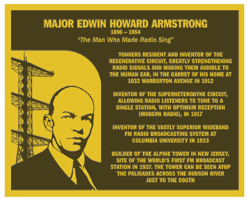
The Armstrong Tower, also known as Alpine Tower, is a distinctive 129.5 meter (425 foot) tall lattice tower featuring three large cross-arms, located atop the Alpine, New Jersey palisades overlooking the Hudson River a few kilometers north of New York City at 40°57'39.0" N and 73°55'21.0" W (40.9607 -73.9225). It is owned by Alpine Tower Company and managed by CSC Management, LLC, both owned by Charles E. Sackermann, Jr.
| Attributes | Values |
|---|
| rdf:type
| |
| rdfs:label
| - Armstrong Tower (de)
- Armstrong Tower (en)
|
| rdfs:comment
| - Armstrong Tower (auch: Alpine Tower) ist ein etwa 130 Meter hoher Gitterturm in Alpine im US-Bundesstaat New Jersey. Er wurde im Zuge der ersten Versuche mit FM-Radio durch Edwin Howard Armstrong 1938 gebaut und benutzt. (de)
- The Armstrong Tower, also known as Alpine Tower, is a distinctive 129.5 meter (425 foot) tall lattice tower featuring three large cross-arms, located atop the Alpine, New Jersey palisades overlooking the Hudson River a few kilometers north of New York City at 40°57'39.0" N and 73°55'21.0" W (40.9607 -73.9225). It is owned by Alpine Tower Company and managed by CSC Management, LLC, both owned by Charles E. Sackermann, Jr. (en)
|
| geo:lat
| |
| geo:long
| |
| foaf:depiction
| |
| dcterms:subject
| |
| Wikipage page ID
| |
| Wikipage revision ID
| |
| Link from a Wikipage to another Wikipage
| |
| Link from a Wikipage to an external page
| |
| sameAs
| |
| dbp:wikiPageUsesTemplate
| |
| thumbnail
| |
| key
| |
| number
| |
| georss:point
| - 40.96083333333333 -73.9225
|
| has abstract
| - The Armstrong Tower, also known as Alpine Tower, is a distinctive 129.5 meter (425 foot) tall lattice tower featuring three large cross-arms, located atop the Alpine, New Jersey palisades overlooking the Hudson River a few kilometers north of New York City at 40°57'39.0" N and 73°55'21.0" W (40.9607 -73.9225). It is owned by Alpine Tower Company and managed by CSC Management, LLC, both owned by Charles E. Sackermann, Jr. The tower is the permanent transmitter site for locally based experimental station WA2XMN and Fairleigh Dickinson University's educational FM station WFDU, in additional to numerous directional radio services (including as a cell site). It is clearly visible from across the Hudson River and is used as a Visual flight rules waypoint by aircraft flying within the New York City Special flight rules area. The tower was originally constructed by inventor Edwin Howard Armstrong in 1938 for developmental activities that led to modern FM radio. The original transmissions (W2XMN) occurred at 42.8 MHz. At the tower base is a building originally used for research by Armstrong, which still has the W2XMN call sign engraved above its main entrance. This building currently houses the Armstrong Field Laboratory, and serves as a museum containing artifacts from the development of FM radio technology. The structure was also used as a temporary transmitter site for some of New York City's television stations after the collapse of the World Trade Center, including its transmitting antenna, during the September 11, 2001 attacks. (en)
- Armstrong Tower (auch: Alpine Tower) ist ein etwa 130 Meter hoher Gitterturm in Alpine im US-Bundesstaat New Jersey. Er wurde im Zuge der ersten Versuche mit FM-Radio durch Edwin Howard Armstrong 1938 gebaut und benutzt. Nach der Zerstörung des World Trade Centers 2001 wichen etliche New Yorker Fernsehstationen auf den Armstrong Tower als Standort ihrer Sendeanlagen aus. Vorteilhaft für diese Nutzung war die gute Zugänglichkeit der Anlage, von der aus man weite Teile New Yorks überblicken kann. Allerdings erwies sich der Standort für dauerhafte Nutzung schnell als nunmehr ungeeignet, da die seit 1938 hinzugekommenen Wolkenkratzer die Signale in mehreren New Yorker Stadtteilen zu sehr dämpften. Heute wird der Turm überwiegend für Richtfunkanlagen benutzt. (de)
|
| prov:wasDerivedFrom
| |
| page length (characters) of wiki page
| |
| foaf:isPrimaryTopicOf
| |
| geo:geometry
| - POINT(-73.922500610352 40.960834503174)
|
| is Link from a Wikipage to another Wikipage
of | |
| is Wikipage redirect
of | |
| is known for
of | |
| is known for
of | |
| is foaf:primaryTopic
of | |

![http://dbpedia.org/describe/?url=http%3A%2F%2Fdbpedia.org%2Fresource%2FArmstrong_Tower]()


![[RDF Data]](/fct/images/sw-rdf-blue.png)


![[RDF Data]](/fct/images/sw-rdf-blue.png)


![[cxml]](/fct/images/cxml_doc.png)
![[csv]](/fct/images/csv_doc.png)
![[text]](/fct/images/ntriples_doc.png)
![[turtle]](/fct/images/n3turtle_doc.png)
![[ld+json]](/fct/images/jsonld_doc.png)
![[rdf+json]](/fct/images/json_doc.png)
![[rdf+xml]](/fct/images/xml_doc.png)
![[atom+xml]](/fct/images/atom_doc.png)
![[html]](/fct/images/html_doc.png)