About: Criggion Radio Station     Goto   Sponge   NotDistinct   Permalink

An Entity of Type : yago:Whole100003553, within Data Space : dbpedia.org:8891 associated with source document(s)
QRcode icon
http://dbpedia.org:8891/describe/?url=http%3A%2F%2Fdbpedia.org%2Fresource%2FCriggion_Radio_Station

Criggion Radio Station was a transmitter site latterly operated by BT on behalf of the UK Ministry of Defence. It was located near the village of Criggion in the parish of Bausley with Criggion, which lies in the county of Powys, Wales. As of May 2013 the remaining parts of the station were reported to be in a state of disrepair.

AttributesValues
rdf:type
rdfs:label
  • GBZ (Rufzeichen) (de)
  • Criggion Radio Station (en)
rdfs:comment
  • GBZ ist das Rufzeichen eines britischen Längstwellensenders, der auf der Frequenz 19,6 kHz von Anthorn in Cumbria (früher von Criggion) aus codierte Signale an getauchte U-Boote sendet. Die Reichweite beträgt mehrere tausend Kilometer. Von demselben Standort aus werden auch Signale von LORAN und MSF (Zeitzeichensender) verbreitet. (de)
  • Criggion Radio Station was a transmitter site latterly operated by BT on behalf of the UK Ministry of Defence. It was located near the village of Criggion in the parish of Bausley with Criggion, which lies in the county of Powys, Wales. As of May 2013 the remaining parts of the station were reported to be in a state of disrepair. (en)
name
  • Criggion (en)
geo:lat
geo:long
foaf:depiction
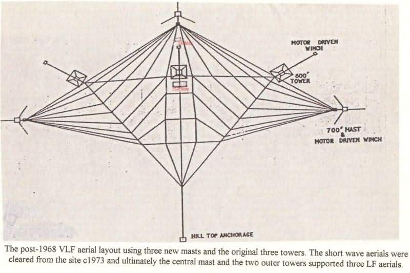
  • http://commons.wikimedia.org/wiki/Special:FilePath///www.oswestry-history.co.uk/criggion/images/vlf-aerial-layout.jpg
  • http://commons.wikimedia.org/wiki/Special:FilePath/Criggion01.jpg
  • http://commons.wikimedia.org/wiki/Special:FilePath/Criggion02.jpg
  • http://commons.wikimedia.org/wiki/Special:FilePath/Criggion03.jpg
  • http://commons.wikimedia.org/wiki/Special:FilePath/Criggion04.jpg
  • http://commons.wikimedia.org/wiki/Special:FilePath/Criggion05.jpg
  • http://commons.wikimedia.org/wiki/Special:FilePath/Criggion06.jpg
  • http://commons.wikimedia.org/wiki/Special:FilePath/Criggion07.jpg
  • http://commons.wikimedia.org/wiki/Special:FilePath/Criggion08.jpg
  • http://commons.wikimedia.org/wiki/Special:FilePath/Criggion09.jpg
  • http://commons.wikimedia.org/wiki/Special:FilePath/Criggion10.jpg
  • http://commons.wikimedia.org/wiki/Special:FilePath/Criggion_Radio_Station.jpg
dcterms:subject
Wikipage page ID
Wikipage revision ID
Link from a Wikipage to another Wikipage
Link from a Wikipage to an external page
sameAs
dbp:wikiPageUsesTemplate
thumbnail
demolished
map name
  • Wales Powys (en)
built
caption
  • Criggion Radio Station in 2011 (en)
location
georss:point
  • 52.72246 -3.06295
has abstract
  • Criggion Radio Station was a transmitter site latterly operated by BT on behalf of the UK Ministry of Defence. It was located near the village of Criggion in the parish of Bausley with Criggion, which lies in the county of Powys, Wales. It was established in World War II as a back-up unit for Rugby Radio Station and took over the latter's traffic for a short period in 1943 following a fire at Rugby. Operating on 19.6 kHz with the callsign GBZ, the station was used until its shutdown on 1 April 2003 for sending messages to submarines. This task (and that of Rugby) is now carried out by the Anthorn radio station. Criggion's VLF antenna was hung from three free-standing steel lattice towers at 182.9 metres (600 ft) tall, three guyed masts at 213.4 metres (700 ft) tall and a rock anchor. The towers and masts were demolished in August 2003 but, although there is now less obvious visible evidence that a large radio station existed on the site, the derelict main transmitting building still survived in 2011 and the foundation sites of the former masts can be still be located on satellite and aerial photographs. As of May 2013 the remaining parts of the station were reported to be in a state of disrepair. (en)
  • GBZ ist das Rufzeichen eines britischen Längstwellensenders, der auf der Frequenz 19,6 kHz von Anthorn in Cumbria (früher von Criggion) aus codierte Signale an getauchte U-Boote sendet. Die Reichweite beträgt mehrere tausend Kilometer. Von demselben Standort aus werden auch Signale von LORAN und MSF (Zeitzeichensender) verbreitet. (de)
Gridref
  • SJ2821614435 (en)
gold:hypernym
prov:wasDerivedFrom
page length (characters) of wiki page
foaf:isPrimaryTopicOf
geo:geometry
  • POINT(-3.0629498958588 52.722461700439)
is Link from a Wikipage to another Wikipage of
is Wikipage redirect of
Faceted Search & Find service v1.17_git139 as of Feb 29 2024


Alternative Linked Data Documents: ODE     Content Formats:   [cxml] [csv]     RDF   [text] [turtle] [ld+json] [rdf+json] [rdf+xml]     ODATA   [atom+xml] [odata+json]     Microdata   [microdata+json] [html]    About   
This material is Open Knowledge   W3C Semantic Web Technology [RDF Data] Valid XHTML + RDFa
OpenLink Virtuoso version 08.03.3332 as of Dec 5 2024, on Linux (x86_64-generic-linux-glibc212), Single-Server Edition (62 GB total memory, 44 GB memory in use)
Data on this page belongs to its respective rights holders.
Virtuoso Faceted Browser Copyright © 2009-2024 OpenLink Software