| dbo:abstract
|
- Das Utladalen ist das tiefste Tal in Norwegen. Es liegt auf dem Gebiet der Kommune Årdal in der Provinz Vestland. Das Tal ist ca. 40 km lang und umgeben von 50 Gipfeln höher als 2000 m. Durch das Tal fließt der Utla, beginnend beim Vettisfossen, Nordeuropas tiefstem unregulierten Wasserfall, und mündend in den . (de)
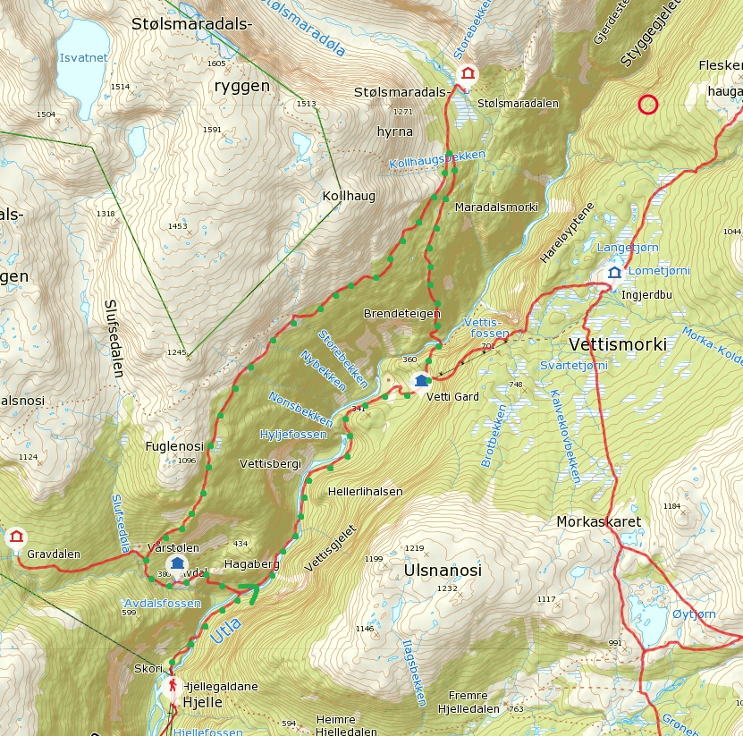
- Utladalen est une vallée située dans la commune d'Årdal, dans le comté de Vestland, dans l'ouest de la Norvège. C'est une vallée glaciaire découpant profondément le massif de Jotunheimen, avec plusieurs sommets de plus de 2 000 m à proximité directe, dont en particulier ceux du massif Hurrungane. La vallée est formée par la confluence des vallées de Storutladalen et Vetle Utladalen, et est rejointe par de nombreuses vallées latérales, dont en particulier Gravdalen, Stølsmaradalen, Midtmaradalen, Maradalen et Gjertvassdalen à l'ouest et Skogadalen, Uradalen, Fleskedalen, Morka-Koldedalen et Hjelledalen à l'est. Ces vallées latérales sont pour la plupart des vallées suspendues, ce qui donne lieu à un grand nombre de chutes d'eau lorsque leurs rivières rejoignent l', la rivière principale qui coule au sein d'Utladalen. La plus célèbre d'entre elles est Vettisfossen, avec une chute libre de 275 m. La vallée et quelques zones alentour sont protégées dans la zone de protection du paysage d'Utladalen, formée en 1980 en même temps que le parc national de Jotunheimen. La randonnée dans la vallée, en particulier jusqu'à Vettisfossen, est une activité touristique populaire.
* La chute Hjellefossen.
* Chutes de la rivière Utla à Hyljefossen.
* La ferme de Vetti gard.
* Portail de la Norvège
* Portail de la montagne (fr)
- Utladalen (or Utladal) is a valley in Årdal Municipality in Vestland county, Norway. It stretches north from the village of Øvre Årdal into the neighboring Luster Municipality. The Avdalen and Fardalen valleys branch off of the main Utladalen valley. Utladalen is Norway's deepest valley. The main valley, when measuring from Øvre Årdal is 25 kilometres (16 mi) long and is surrounded by dozens of mountain peaks that are all more than 2,000 metres (6,600 ft) in height. From Øvre Årdal, a comfortable walking road has been constructed, funded by voluntary contributions. The road passes through the Vetti farm area and crosses the Utla river on four spectacular bridges. The walking path ends at one of Norway's tallest waterfalls, Vettisfossen. Since Utladalen is considered to be unique in Norway and internationally, the Utladalen Landscape Protection Area was established along with the adjacent Jotunheim National Park in 1980 and covers about 300 square kilometres (120 sq mi). It includes both the valley and areas that extend both westward and northward to Jotunheim National Park, and eastward to lake Tyin. (en)
- Utladalen (het Utladal) is een dal in de gemeente Årdal in de Noorse provincie Sogn og Fjordane. Het dal is vernoemd naar de rivier de die via Årdalsvatnet uitmondt in het Sognefjord. Het dal geldt als het diepste rivierdal van Noorwegen. De omgeving van het het dal, tot aan het nationaal park Jotunheimen, is beschermd natuurgebied. (nl)
|
| dbo:thumbnail
| |
| dbo:wikiPageExternalLink
| |
| dbo:wikiPageID
| |
| dbo:wikiPageLength
|
- 3214 (xsd:nonNegativeInteger)
|
| dbo:wikiPageRevisionID
| |
| dbo:wikiPageWikiLink
| |
| dbp:elevationM
| |
| dbp:labelPosition
| |
| dbp:location
| |
| dbp:mapCaption
|
- Location of the valley (en)
|
| dbp:name
| |
| dbp:photo
|
- Utladalen Vetti 2.jpg (en)
|
| dbp:towns
| |
| dbp:type
| |
| dbp:wikiPageUsesTemplate
| |
| dcterms:subject
| |
| gold:hypernym
| |
| georss:point
| |
| rdf:type
| |
| rdfs:comment
|
- Das Utladalen ist das tiefste Tal in Norwegen. Es liegt auf dem Gebiet der Kommune Årdal in der Provinz Vestland. Das Tal ist ca. 40 km lang und umgeben von 50 Gipfeln höher als 2000 m. Durch das Tal fließt der Utla, beginnend beim Vettisfossen, Nordeuropas tiefstem unregulierten Wasserfall, und mündend in den . (de)
- Utladalen (het Utladal) is een dal in de gemeente Årdal in de Noorse provincie Sogn og Fjordane. Het dal is vernoemd naar de rivier de die via Årdalsvatnet uitmondt in het Sognefjord. Het dal geldt als het diepste rivierdal van Noorwegen. De omgeving van het het dal, tot aan het nationaal park Jotunheimen, is beschermd natuurgebied. (nl)
- Utladalen est une vallée située dans la commune d'Årdal, dans le comté de Vestland, dans l'ouest de la Norvège. C'est une vallée glaciaire découpant profondément le massif de Jotunheimen, avec plusieurs sommets de plus de 2 000 m à proximité directe, dont en particulier ceux du massif Hurrungane. La vallée est formée par la confluence des vallées de Storutladalen et Vetle Utladalen, et est rejointe par de nombreuses vallées latérales, dont en particulier Gravdalen, Stølsmaradalen, Midtmaradalen, Maradalen et Gjertvassdalen à l'ouest et Skogadalen, Uradalen, Fleskedalen, Morka-Koldedalen et Hjelledalen à l'est. Ces vallées latérales sont pour la plupart des vallées suspendues, ce qui donne lieu à un grand nombre de chutes d'eau lorsque leurs rivières rejoignent l', la rivière principale qui (fr)
- Utladalen (or Utladal) is a valley in Årdal Municipality in Vestland county, Norway. It stretches north from the village of Øvre Årdal into the neighboring Luster Municipality. The Avdalen and Fardalen valleys branch off of the main Utladalen valley. (en)
|
| rdfs:label
|
- Utladalen (en)
- Utladalen (de)
- Utladalen (fr)
- Utladalen (nl)
|
| owl:sameAs
| |
| geo:geometry
|
- POINT(7.9708333015442 61.400001525879)
|
| geo:lat
| |
| geo:long
| |
| prov:wasDerivedFrom
| |
| foaf:depiction
| |
| foaf:isPrimaryTopicOf
| |
| is dbo:mouthMountain
of | |
| is dbo:mouthPlace
of | |
| is dbo:wikiPageRedirects
of | |
| is dbo:wikiPageWikiLink
of | |
| is dbp:mouthLocation
of | |
| is dbp:source1Location
of | |
| is foaf:primaryTopic
of | |


