| dbo:abstract
|
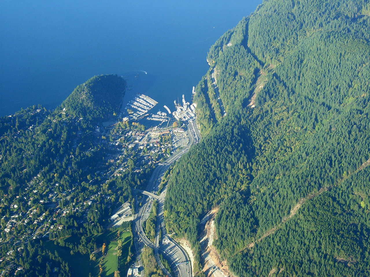
- Horseshoe Bay (Sḵwx̱wú7mesh: Ch'ax̱áy̓, IPA: [t͡ʃʼaχaj̰]) is a community of about 1,000 permanent residents, located in West Vancouver, in the Canadian province of British Columbia. Situated on the western tip of West Vancouver at the entrance to Howe Sound, the village marks the western end of Highway 1 on mainland British Columbia (and furthermore the main route of the Trans-Canada Highway on the Canadian mainland). It also serves as the southern end of the Sea-to-Sky Highway, with Lions Bay just 15 minutes north. Horseshoe Bay is the location of the third-busiest BC Ferries terminal, the Horseshoe Bay ferry terminal. Because of the presence of the ferry terminal, it is considered a control city on the Upper Levels Highway westbound. (en)
- Horseshoe Bay (littéralement en français « baie du fer à cheval ») est une communauté côtière de Colombie-Britannique au Canada, située à l'embouchure de la baie Howe (Howe Sound) au bord du détroit de Géorgie (Strait of Georgia) qui sépare l'île de Vancouver du continent. Horseshoe Bay est rattachée à la municipalité de West Vancouver. Horseshoe Bay est réputée pour son caractère pittoresque, elle marque le début de la Sea to sky highway (nom donné à la partie la plus touristique de l'autoroute provinciale 99 qui relie notamment Vancouver (au bord de la mer) à Whistler (dans les montagnes). (fr)
- ホースシュー・ベイ(Horseshoe Bay)は、カナダ・ブリティッシュコロンビア州のウェストバンクーバーにある、人口約1000人の集落。ウェストバンクーバーの西端、の入り口に位置し、ブリティッシュコロンビア州道1号(British Columbia Highway 1)西の終点かつトランスカナダハイウェイの本土側の終点で、州道99号(British Columbia Highway 99)の南の終点である。 ホースシュー・ベイは、で3番目に利用の多いの所在地である。バンクーバー本土からバンクーバー島のナナイモに渡るフェリー航路のうちの1つが就航する。 (ja)
- 馬蹄灣(英語:Horseshoe Bay)是加拿大卑詩省西溫哥華一個小海灣和社區,約有1000名居民。該區座落西溫的最西處,瀕臨豪灣,並且是卑詩省1號公路(橫加公路)大溫哥華段的西端。卑詩省99號公路從東面掠過馬蹄灣,向北通往獅子灣和威士拿等地。卑詩渡輪公司亦於馬蹄灣設有一個大型渡輪碼頭,服務前往乃磨、和寶雲島的航綫;每年使用此渡輪碼頭的汽車達250萬架次,年度人流更達700萬人次。 英國皇家海軍於19世紀在豪灣一帶進行勘察時,以沿岸白色的峭壁將馬蹄灣以西的小半島命名為「白崖角」(White Cliff Point)。後來一名叫亞爾伯·懷特(Albert Whyte)的上校在該處買地,並於1909年聯同查爾斯·塔珀在此建立白崖鎮址。太平洋大東方鐵路於1914年開通至此,懷特上校便乘機成功游說鐵路公司將車站的名稱從「White Cliff」改拼為「Whytecliff」。然而,當地民眾卻以海灣的形狀將該帶稱為「Horseshoe Bay」,「Whytecliff」一名則不被廣泛使用,因此區内郵局的名稱於1942年從「Whytecliff」改為「Horseshoe Bay」。 馬蹄灣一帶早期交通不便,因此人煙稀少。丹·塞威爾於1931年在馬蹄灣建立一個小艇碼頭後,該區的常住人口才有所上升。前往乃磨的黑球渡輪航綫從1950年代起停靠馬蹄灣,而連接馬蹄灣和的鐵路綫也於同期開通,令馬蹄灣的對外交通有所改善。卑詩渡輪於1960年在馬蹄灣建立碼頭後,更鞏固其大溫地區對外門戶的地位。 (zh)
|
| dbo:thumbnail
| |
| dbo:wikiPageExternalLink
| |
| dbo:wikiPageID
| |
| dbo:wikiPageLength
|
- 1878 (xsd:nonNegativeInteger)
|
| dbo:wikiPageRevisionID
| |
| dbo:wikiPageWikiLink
| |
| dbp:wikiPageUsesTemplate
| |
| dcterms:subject
| |
| gold:hypernym
| |
| georss:point
|
- 49.37388888888889 -123.27722222222222
|
| rdf:type
| |
| rdfs:comment
|
- Horseshoe Bay (littéralement en français « baie du fer à cheval ») est une communauté côtière de Colombie-Britannique au Canada, située à l'embouchure de la baie Howe (Howe Sound) au bord du détroit de Géorgie (Strait of Georgia) qui sépare l'île de Vancouver du continent. Horseshoe Bay est rattachée à la municipalité de West Vancouver. Horseshoe Bay est réputée pour son caractère pittoresque, elle marque le début de la Sea to sky highway (nom donné à la partie la plus touristique de l'autoroute provinciale 99 qui relie notamment Vancouver (au bord de la mer) à Whistler (dans les montagnes). (fr)
- ホースシュー・ベイ(Horseshoe Bay)は、カナダ・ブリティッシュコロンビア州のウェストバンクーバーにある、人口約1000人の集落。ウェストバンクーバーの西端、の入り口に位置し、ブリティッシュコロンビア州道1号(British Columbia Highway 1)西の終点かつトランスカナダハイウェイの本土側の終点で、州道99号(British Columbia Highway 99)の南の終点である。 ホースシュー・ベイは、で3番目に利用の多いの所在地である。バンクーバー本土からバンクーバー島のナナイモに渡るフェリー航路のうちの1つが就航する。 (ja)
- Horseshoe Bay (Sḵwx̱wú7mesh: Ch'ax̱áy̓, IPA: [t͡ʃʼaχaj̰]) is a community of about 1,000 permanent residents, located in West Vancouver, in the Canadian province of British Columbia. Situated on the western tip of West Vancouver at the entrance to Howe Sound, the village marks the western end of Highway 1 on mainland British Columbia (and furthermore the main route of the Trans-Canada Highway on the Canadian mainland). It also serves as the southern end of the Sea-to-Sky Highway, with Lions Bay just 15 minutes north. (en)
- 馬蹄灣(英語:Horseshoe Bay)是加拿大卑詩省西溫哥華一個小海灣和社區,約有1000名居民。該區座落西溫的最西處,瀕臨豪灣,並且是卑詩省1號公路(橫加公路)大溫哥華段的西端。卑詩省99號公路從東面掠過馬蹄灣,向北通往獅子灣和威士拿等地。卑詩渡輪公司亦於馬蹄灣設有一個大型渡輪碼頭,服務前往乃磨、和寶雲島的航綫;每年使用此渡輪碼頭的汽車達250萬架次,年度人流更達700萬人次。 英國皇家海軍於19世紀在豪灣一帶進行勘察時,以沿岸白色的峭壁將馬蹄灣以西的小半島命名為「白崖角」(White Cliff Point)。後來一名叫亞爾伯·懷特(Albert Whyte)的上校在該處買地,並於1909年聯同查爾斯·塔珀在此建立白崖鎮址。太平洋大東方鐵路於1914年開通至此,懷特上校便乘機成功游說鐵路公司將車站的名稱從「White Cliff」改拼為「Whytecliff」。然而,當地民眾卻以海灣的形狀將該帶稱為「Horseshoe Bay」,「Whytecliff」一名則不被廣泛使用,因此區内郵局的名稱於1942年從「Whytecliff」改為「Horseshoe Bay」。 (zh)
|
| rdfs:label
|
- Horseshoe Bay, West Vancouver (en)
- Horseshoe Bay (fr)
- ホースシュー・ベイ (カナダ) (ja)
- 馬蹄灣 (西溫哥華) (zh)
|
| owl:sameAs
|
- freebase:Horseshoe Bay, West Vancouver
- yago-res:Horseshoe Bay, West Vancouver
- wikidata:Horseshoe Bay, West Vancouver
- geodata:Horseshoe Bay, West Vancouver
- http://ceb.dbpedia.org/resource/Horseshoe_Bay_(luuk_sa_Kanada,_British_Columbia,_lat_49,38,_long_-123,27)
- dbpedia-fr:Horseshoe Bay, West Vancouver
- dbpedia-ja:Horseshoe Bay, West Vancouver
- dbpedia-zh:Horseshoe Bay, West Vancouver
- https://global.dbpedia.org/id/2uRkR
|
| geo:geometry
|
- POINT(-123.27722167969 49.373889923096)
|
| geo:lat
| |
| geo:long
| |
| prov:wasDerivedFrom
| |
| foaf:depiction
| |
| foaf:isPrimaryTopicOf
| |
| is dbo:wikiPageDisambiguates
of | |
| is dbo:wikiPageRedirects
of | |
| is dbo:wikiPageWikiLink
of | |
| is dbp:shipRoute
of | |
| is foaf:primaryTopic
of | |


