| dbo:abstract
|
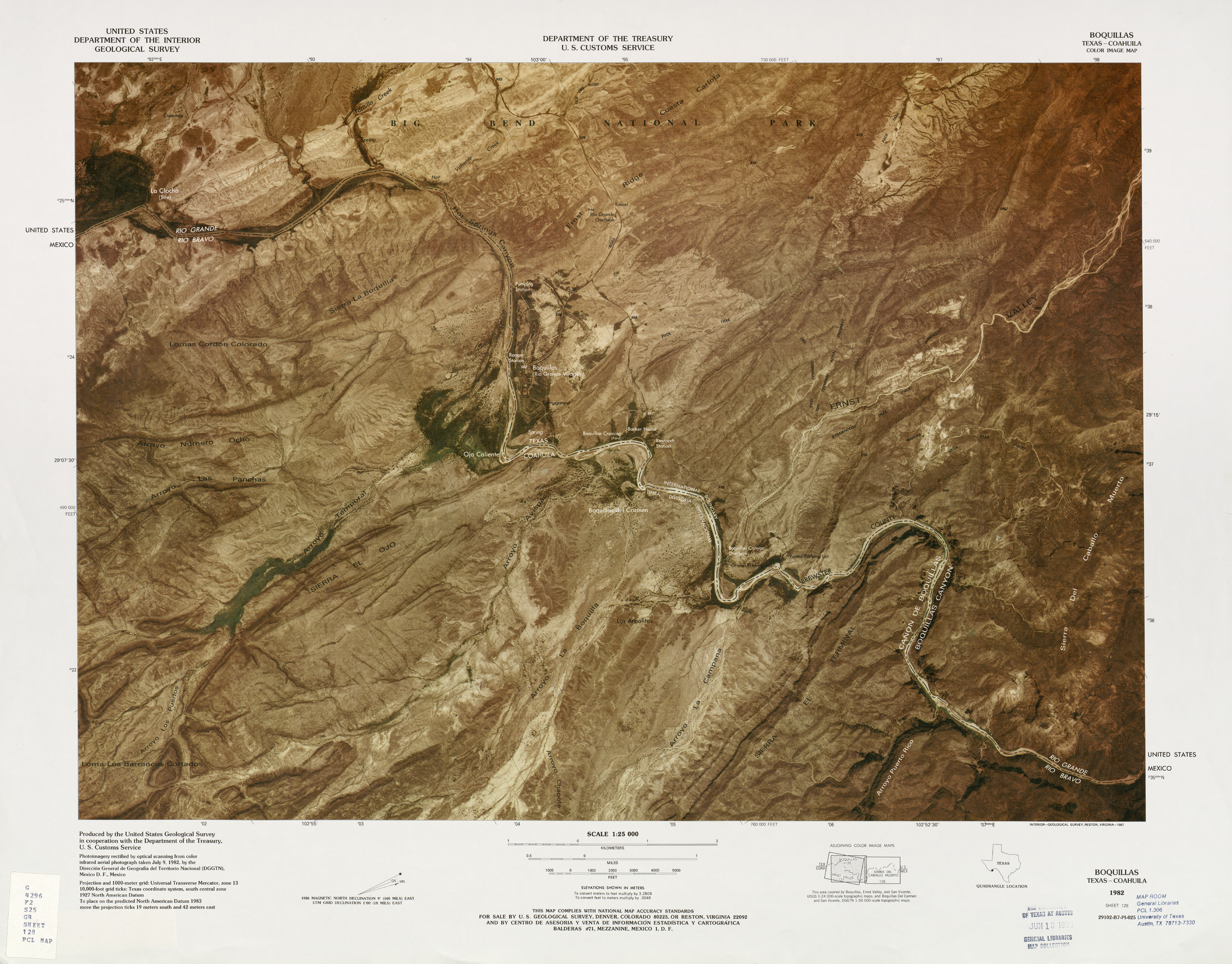
- Boquillas was a small settlement in Texas, located on the northern banks of the Rio Grande. It was located within Brewster County, 5 miles northeast of San Vicente, Texas. The place existed to service the mining operations at Boquillas del Carmen, Mexico, just across the Rio Grande. Between 1901 and 1936, María G. Sada ran "Chata's Place" the only store and restaurant in the Boquillas area at that time. Boquillas, Texas is now in Big Bend National Park. It is now usually known as Rio Grande Village, and consists of a ranger station and other buildings to serve visitors to the park. In 1916, over 200 Villistas raided Boquillas and nearby Glenn Springs, Texas. At Boquillas, the Americans were able to capture one of the raider commanders, but lost two men who were taken captive by the Mexicans. The Rio Grande border crossing to Boquillas del Carmen was closed in 2002. On January 7, 2011, the U.S. National Park Service announced plans to reopen the crossing. After multiple delays, the unmanned border station was finally opened on April 11, 2013. (en)
- Boquillas war eine Ortschaft im südlichen Teil des Brewster Countys, sie lag am Ufer des Rio Grande. Der Ort ist heute Teil des Big-Bend-Nationalparks und beherbergt unter dem Namen Rio Grande Village eine Ranger-Station und mehrere Gebäude zur Versorgung der Touristen. Boquillas ist ein spanisches Wort und bedeutet „viele kleine Münder“, was wohl Bezug nimmt auf die vielen kleinen Wasserläufe bzw. nur temporär Wasser führenden Trockentäler, die von der Sierra Del Carmen kommend in den Rio Grande münden. (de)
- Boquillas es una localidad del estado de Texas, Estados Unidos de América, localizada en el Condado de Brewster y en la Frontera entre Estados Unidos y México en la rivera del Río Bravo, cruzando la frontera se encuentra la población de Boquillas del Carmen, Coahuila, México. Está localizada dentro del Parque nacional Big Bend. (es)
|
| dbo:areaCode
| |
| dbo:elevation
|
- 562.000000 (xsd:double)
- 562.051200 (xsd:double)
|
| dbo:postalCode
| |
| dbo:subdivision
| |
| dbo:thumbnail
| |
| dbo:timeZone
| |
| dbo:type
| |
| dbo:utcOffset
| |
| dbo:wikiPageExternalLink
| |
| dbo:wikiPageID
| |
| dbo:wikiPageLength
|
- 11303 (xsd:nonNegativeInteger)
|
| dbo:wikiPageRevisionID
| |
| dbo:wikiPageWikiLink
| |
| dbp:aprHighF
| |
| dbp:aprLowF
| |
| dbp:aprMeanF
| |
| dbp:aprPrecipitationDays
| |
| dbp:aprPrecipitationInch
| |
| dbp:aprRecordHighF
| |
| dbp:aprRecordLowF
| |
| dbp:aprSnowInch
| |
| dbp:areaCode
| |
| dbp:areaCodeType
| |
| dbp:augHighF
| |
| dbp:augLowF
| |
| dbp:augMeanF
| |
| dbp:augPrecipitationDays
| |
| dbp:augPrecipitationInch
| |
| dbp:augRecordHighF
| |
| dbp:augRecordLowF
| |
| dbp:augSnowInch
| |
| dbp:blank1Info
| |
| dbp:blank1Name
| |
| dbp:date
| |
| dbp:decHighF
| |
| dbp:decLowF
| |
| dbp:decMeanF
| |
| dbp:decPrecipitationDays
| |
| dbp:decPrecipitationInch
| |
| dbp:decRecordHighF
| |
| dbp:decRecordLowF
| |
| dbp:decSnowInch
| |
| dbp:elevationFt
| |
| dbp:elevationM
| |
| dbp:febHighF
| |
| dbp:febLowF
| |
| dbp:febMeanF
| |
| dbp:febPrecipitationDays
| |
| dbp:febPrecipitationInch
| |
| dbp:febRecordHighF
| |
| dbp:febRecordLowF
| |
| dbp:febSnowInch
| |
| dbp:imageCaption
|
- Boquillas in Big Bend (en)
|
| dbp:imageSkyline
|
- Rio Grande Village Overlook 2.JPG (en)
|
| dbp:janHighF
| |
| dbp:janLowF
| |
| dbp:janMeanF
| |
| dbp:janPrecipitationDays
| |
| dbp:janPrecipitationInch
| |
| dbp:janRecordHighF
| |
| dbp:janRecordLowF
| |
| dbp:janSnowInch
| |
| dbp:julHighF
| |
| dbp:julLowF
| |
| dbp:julMeanF
| |
| dbp:julPrecipitationDays
| |
| dbp:julPrecipitationInch
| |
| dbp:julRecordHighF
| |
| dbp:julRecordLowF
| |
| dbp:julSnowInch
| |
| dbp:junHighF
| |
| dbp:junLowF
| |
| dbp:junMeanF
| |
| dbp:junPrecipitationDays
| |
| dbp:junPrecipitationInch
| |
| dbp:junRecordHighF
| |
| dbp:junRecordLowF
| |
| dbp:junSnowInch
| |
| dbp:location
| |
| dbp:marHighF
| |
| dbp:marLowF
| |
| dbp:marMeanF
| |
| dbp:marPrecipitationDays
| |
| dbp:marPrecipitationInch
| |
| dbp:marRecordHighF
| |
| dbp:marRecordLowF
| |
| dbp:marSnowInch
| |
| dbp:mayHighF
| |
| dbp:mayLowF
| |
| dbp:mayMeanF
| |
| dbp:mayPrecipitationDays
| |
| dbp:mayPrecipitationInch
| |
| dbp:mayRecordHighF
| |
| dbp:mayRecordLowF
| |
| dbp:maySnowInch
| |
| dbp:nickname
| |
| dbp:novHighF
| |
| dbp:novLowF
| |
| dbp:novMeanF
| |
| dbp:novPrecipitationDays
| |
| dbp:novPrecipitationInch
| |
| dbp:novRecordHighF
| |
| dbp:novRecordLowF
| |
| dbp:novSnowInch
| |
| dbp:octHighF
| |
| dbp:octLowF
| |
| dbp:octMeanF
| |
| dbp:octPrecipitationDays
| |
| dbp:octPrecipitationInch
| |
| dbp:octRecordHighF
| |
| dbp:octRecordLowF
| |
| dbp:octSnowInch
| |
| dbp:officialName
| |
| dbp:postalCode
| |
| dbp:postalCodeType
| |
| dbp:pushpinMap
| |
| dbp:pushpinMapCaption
|
- Location within Texas (en)
|
| dbp:pushpinRelief
| |
| dbp:sepHighF
| |
| dbp:sepLowF
| |
| dbp:sepMeanF
| |
| dbp:sepPrecipitationDays
| |
| dbp:sepPrecipitationInch
| |
| dbp:sepRecordHighF
| |
| dbp:sepRecordLowF
| |
| dbp:sepSnowInch
| |
| dbp:settlementType
| |
| dbp:singleLine
| |
| dbp:source
| |
| dbp:subdivisionName
| |
| dbp:subdivisionType
| |
| dbp:timezone
| |
| dbp:timezoneDst
| |
| dbp:unitPrecipitationDays
| |
| dbp:unitPref
| |
| dbp:utcOffset
| |
| dbp:utcOffsetDst
| |
| dbp:wikiPageUsesTemplate
| |
| dbp:yearHighF
| |
| dbp:yearLowF
| |
| dbp:yearMeanF
| |
| dbp:yearPrecipitationDays
| |
| dbp:yearPrecipitationInch
| |
| dbp:yearRecordHighF
| |
| dbp:yearRecordLowF
| |
| dbp:yearSnowInch
| |
| dcterms:subject
| |
| gold:hypernym
| |
| georss:point
|
- 29.182777777777776 -102.96152777777777
|
| rdf:type
| |
| rdfs:comment
|
- Boquillas war eine Ortschaft im südlichen Teil des Brewster Countys, sie lag am Ufer des Rio Grande. Der Ort ist heute Teil des Big-Bend-Nationalparks und beherbergt unter dem Namen Rio Grande Village eine Ranger-Station und mehrere Gebäude zur Versorgung der Touristen. Boquillas ist ein spanisches Wort und bedeutet „viele kleine Münder“, was wohl Bezug nimmt auf die vielen kleinen Wasserläufe bzw. nur temporär Wasser führenden Trockentäler, die von der Sierra Del Carmen kommend in den Rio Grande münden. (de)
- Boquillas es una localidad del estado de Texas, Estados Unidos de América, localizada en el Condado de Brewster y en la Frontera entre Estados Unidos y México en la rivera del Río Bravo, cruzando la frontera se encuentra la población de Boquillas del Carmen, Coahuila, México. Está localizada dentro del Parque nacional Big Bend. (es)
- Boquillas was a small settlement in Texas, located on the northern banks of the Rio Grande. It was located within Brewster County, 5 miles northeast of San Vicente, Texas. The place existed to service the mining operations at Boquillas del Carmen, Mexico, just across the Rio Grande. Between 1901 and 1936, María G. Sada ran "Chata's Place" the only store and restaurant in the Boquillas area at that time. (en)
|
| rdfs:label
|
- Boquillas, Texas (en)
- Boquillas (Texas) (de)
- Boquillas (es)
|
| owl:sameAs
| |
| geo:geometry
|
- POINT(-102.96152496338 29.182777404785)
|
| geo:lat
| |
| geo:long
| |
| prov:wasDerivedFrom
| |
| foaf:depiction
| |
| foaf:isPrimaryTopicOf
| |
| foaf:name
| |
| foaf:nick
| |
| is dbo:wikiPageDisambiguates
of | |
| is dbo:wikiPageRedirects
of | |
| is dbo:wikiPageWikiLink
of | |
| is foaf:primaryTopic
of | |


