| dbo:PopulatedPlace/areaTotal
| |
| dbo:abstract
|
- 'Anata (àrab: عناتا, ʿAnātā) és una vila palestina de la governació de Jerusalem, a Cisjordània, situada 4 kilòmetres al nord-oest de la ciutat vella de Jerusalem. Segons l'Oficina Central Palestina d'Estadístiques tenia una població de 14.085 habitants el 2016. La seva àrea és de 30,603 dúnams, dels quals la meitat resten en mans del Municipi de Jerusalem israelià i 1.654 en àrea construïda palestina. Des de 1967 'Anata està ocupada per Israel. Junt amb el camp de Shu'afat, la vila és gairebé envoltada pel Mur de Cisjordània, tallant-la de Jerusalem i els pobles circumdants excepte un punt de control a l'oest i una carretera al nord-est que dona accés a la resta de Cisjordània. (ca)
- تقع قرية عناتا في الشمال الشرقي لمدينة القدس وتتبع محافظة القدس، وتعتبر مساحة أراضي القرية من الأكبر على مستوى الضفة الغربية إلا أن معظمها صودر. يحدها من الشمال قرية حزما ومن الجنوب قرية العيسوية ومن الغرب شعفاط ومن الشرق قرية النبي موسى. (ar)
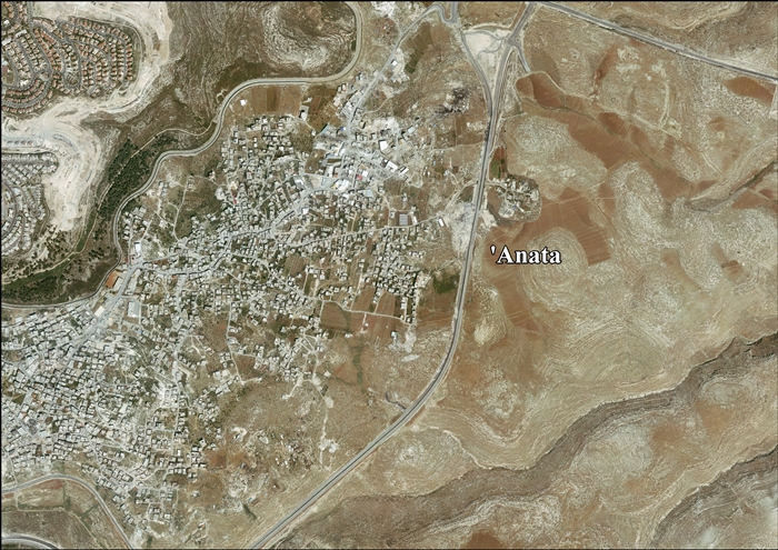
- 'Anata (Arabic: عناتا) is a Palestinian town in the Jerusalem Governorate in the central West Bank, located four kilometers northeast of Jerusalem's Old City. According to the Palestinian Central Bureau of Statistics, 'Anata had a population of 9,600 in 2006. Its total land area is 30,603 dunams, of which over half now lies within the Israeli Jerusalem municipality and 1,654 is Palestinian built-up area. Since 1967, 'Anata has been occupied by Israel. Together with Shu'afat refugee camp, the village is almost surrounded by the separation barrier, cutting it off from Jerusalem and surrounding villages except for a checkpoint in the west and a road in the north-east that gives access to the rest of the West Bank. (en)
- ʿAnātā (in arabo: عناتا) è un villaggio palestinese della Cisgiordania centrale, nel Governatorato di Gerusalemme, sito a quattro chilometri a NE di Gerusalemme. Secondo l', ʿAnātā aveva una popolazione di 9.600 persone nel 2006. La sua superficie complessiva è pari a 30,603 dunum, di cui più della metà era nel gennaio 2012 ormai all'interno dell'area progressivamente ingrandita della città di Gerusalemme mentre 1,654 dunum costituiscono l'area abitata da palestinesi. (it)
- Anata (arab. عناتا) – miasto w Autonomii Palestyńskiej (środkowy Zachodni Brzeg, muhafaza Jerozolima). Według danych oficjalnych na rok 2007 liczyła 11 946 mieszkańców. (pl)
|
| dbo:areaTotal
|
- 30600000.000000 (xsd:double)
|
| dbo:country
| |
| dbo:governmentType
| |
| dbo:politicalLeader
| |
| dbo:populationTotal
|
- 9600 (xsd:nonNegativeInteger)
|
| dbo:subdivision
| |
| dbo:thumbnail
| |
| dbo:wikiPageExternalLink
| |
| dbo:wikiPageID
| |
| dbo:wikiPageLength
|
- 23451 (xsd:nonNegativeInteger)
|
| dbo:wikiPageRevisionID
| |
| dbo:wikiPageWikiLink
| |
| dbp:areaTotalDunam
| |
| dbp:areaTotalKm
| |
| dbp:blankInfoSec
|
- Anata, personal name (en)
|
| dbp:blankNameSec
| |
| dbp:establishedTitle
| |
| dbp:governmentType
| |
| dbp:gridName
| |
| dbp:gridPosition
| |
| dbp:imageCaption
| |
| dbp:imageSkyline
|
- Anathoth , p. 549 in Thomson, 1859.jpg (en)
|
| dbp:leaderName
| |
| dbp:leaderTitle
|
- Head of Municipality (en)
|
| dbp:name
| |
| dbp:populationAsOf
| |
| dbp:populationDensityKm
| |
| dbp:populationTotal
| |
| dbp:pushpinMap
| |
| dbp:pushpinMapCaption
|
- Location of 'Anata within Palestine (en)
|
| dbp:subdivisionName
| |
| dbp:subdivisionType
| |
| dbp:translitLang
| |
| dbp:translitLang1Info
| |
| dbp:translitLang1Type
| |
| dbp:type
| |
| dbp:unitPref
| |
| dbp:wikiPageUsesTemplate
| |
| dcterms:subject
| |
| gold:hypernym
| |
| georss:point
|
- 31.81277777777778 35.261944444444445
|
| rdf:type
| |
| rdfs:comment
|
- 'Anata (àrab: عناتا, ʿAnātā) és una vila palestina de la governació de Jerusalem, a Cisjordània, situada 4 kilòmetres al nord-oest de la ciutat vella de Jerusalem. Segons l'Oficina Central Palestina d'Estadístiques tenia una població de 14.085 habitants el 2016. La seva àrea és de 30,603 dúnams, dels quals la meitat resten en mans del Municipi de Jerusalem israelià i 1.654 en àrea construïda palestina. Des de 1967 'Anata està ocupada per Israel. Junt amb el camp de Shu'afat, la vila és gairebé envoltada pel Mur de Cisjordània, tallant-la de Jerusalem i els pobles circumdants excepte un punt de control a l'oest i una carretera al nord-est que dona accés a la resta de Cisjordània. (ca)
- تقع قرية عناتا في الشمال الشرقي لمدينة القدس وتتبع محافظة القدس، وتعتبر مساحة أراضي القرية من الأكبر على مستوى الضفة الغربية إلا أن معظمها صودر. يحدها من الشمال قرية حزما ومن الجنوب قرية العيسوية ومن الغرب شعفاط ومن الشرق قرية النبي موسى. (ar)
- 'Anata (Arabic: عناتا) is a Palestinian town in the Jerusalem Governorate in the central West Bank, located four kilometers northeast of Jerusalem's Old City. According to the Palestinian Central Bureau of Statistics, 'Anata had a population of 9,600 in 2006. Its total land area is 30,603 dunams, of which over half now lies within the Israeli Jerusalem municipality and 1,654 is Palestinian built-up area. Since 1967, 'Anata has been occupied by Israel. Together with Shu'afat refugee camp, the village is almost surrounded by the separation barrier, cutting it off from Jerusalem and surrounding villages except for a checkpoint in the west and a road in the north-east that gives access to the rest of the West Bank. (en)
- ʿAnātā (in arabo: عناتا) è un villaggio palestinese della Cisgiordania centrale, nel Governatorato di Gerusalemme, sito a quattro chilometri a NE di Gerusalemme. Secondo l', ʿAnātā aveva una popolazione di 9.600 persone nel 2006. La sua superficie complessiva è pari a 30,603 dunum, di cui più della metà era nel gennaio 2012 ormai all'interno dell'area progressivamente ingrandita della città di Gerusalemme mentre 1,654 dunum costituiscono l'area abitata da palestinesi. (it)
- Anata (arab. عناتا) – miasto w Autonomii Palestyńskiej (środkowy Zachodni Brzeg, muhafaza Jerozolima). Według danych oficjalnych na rok 2007 liczyła 11 946 mieszkańców. (pl)
|
| rdfs:label
|
- 'Anata (en)
- عناتا (ar)
- 'Anata (ca)
- 'Anata (it)
- Anata (Palestyna) (pl)
|
| owl:sameAs
| |
| geo:geometry
|
- POINT(35.261943817139 31.8127784729)
|
| geo:lat
| |
| geo:long
| |
| prov:wasDerivedFrom
| |
| foaf:depiction
| |
| foaf:isPrimaryTopicOf
| |
| foaf:name
| |
| is dbo:wikiPageDisambiguates
of | |
| is dbo:wikiPageRedirects
of | |
| is dbo:wikiPageWikiLink
of | |
| is foaf:primaryTopic
of | |
,_p._549_in_Thomson,_1859.jpg?width=300)


,_p._549_in_Thomson,_1859.jpg)