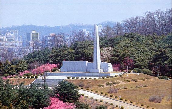
The Pothong River (Pot'ong River, Potonggang or Potong) is a river in North Korea. It flows through the capital Pyongyang and is a tributary of the Taedong River. There are several bridges across the river in Pyongyang, including one at its mouth called the "Pothong Bridge"; however, the largest is the one known as "Ansan Bridge", 39°02′02″N 125°42′15″E / 39.03389°N 125.70417°E, which supports the main east-west divided highway.
| Attributes | Values |
|---|
| rdf:type
| |
| rdfs:label
| - Potchong (cs)
- Pothong-gang (de)
- 普通江 (ja)
- 보통강 (ko)
- Pothong River (en)
- 普通江 (zh)
|
| rdfs:comment
| - Potchong (korejsky 보통강 – Potchong gang) je řeka v Severní Koreji, pravý přítok Tedongu v úmoří Žlutého moře. Vytéká z přehrady v provincii Jižní Pchjongan a teče převážně na jih do hlavního města Pchjongjangu, kde se zprava vlévá do Tedongu. V Pchjongjangu teče nejprve přes obvody a Hjŏngdžesangujŏk a následně je hraniční řekou mezi obvody: Na jejím pravém břehu leží obvod Mangjŏngdägujŏk a na levém břehu obvody Potchongganggujŏk (který je po řece pojmenován) a . (cs)
- Der Pothong ist ein rechter Nebenfluss des Taedong. Er verläuft durch die nordkoreanische Hauptstadt Pjöngjang und bildet die Grenze zwischen mehreren Stadtbezirken. Nach ihm wurden der Stadtbezirk Pot’onggang-guyŏk und das historische Pothong-Tor benannt. Der Fluss wurde im Jahr 1946 kanalisiert, nachdem es mehrmals zu Überschwemmungen kam. Der erste Spatenstich wurde von dem damaligen nordkoreanischen Machthaber Kim Il-sung vorgenommen. Schlämme aus dem Fluss werden von der Fabrik für organische Kombinationsdünger aufbereitet. (de)
- 보통강(普通江)은 평안남도 평원군에서 발원해 평양직할시까지 흐르다 대동강으로 흘러들어가는 길이 55.2km의 강이다. 평양시내를 흘러 1942년 큰 홍수가 발생하였다. 해방 이후 북조선인민위원회 시절인 1946년 5월 21일 착공한 에 의해 수로를 직강화하고 원래 수로는 정비하여 보통강운하로 활용하며 원래의 보통강 주변에 를 조성하였다. (ko)
- 普通江 (ポトンガン、朝鮮語: 보통강)は、朝鮮民主主義人民共和国を流れる大同江水系の河川。首都平壌を流れ、大同江に注ぐ 。 平壌には普通江にかかる橋がいくつかあり、その中の一つが「普通橋」と呼ばれる河口の橋である。しかし、最大のものは「安山橋」と呼ばれる橋であり、東西を結ぶ主要な高速道路を支えている。 1946年以前、平壌以西の川沿い(氾濫原)から大同江に至るまでの耕地は毎年洪水に見舞われていた。この地域は土城廊と呼ばれていた。 この地域の農民は洪水が収まると毎年家を建て直すため、小屋や竪穴建物などの仮設住宅を建設していた 。 1946年には普通江整備事業として土城廊に河道が整備された。現在、土城廊は平壌市の一部である。 1971年、政府は川の左岸にある丘、烽火山の公園に普通江改修の記念碑を建てた。1945年の金日成主席の土城廓訪問と1946年の河道整備を記念した物である。 1976年、は1945年の金日成主席の土城廊訪問を記念した切手を発行した。 1998年には、普通江河道の起工式で水路工事の鍬入れをする金日成を撮影した切手記念シートを発行した 。 (ja)
- 普通江(朝鲜语:보통강/普通江 Pot'onggang */?)是朝鮮民主主義人民共和國一條河流,全長55.2公里,上游發源於平安南道平原郡,下游匯入平壤大同江。 在平壤,以普通江命名的地名甚多,例如其新舊河道圍繞而成的區域即為普通江區,普通江畔的平壤西門即為普通門,等等。“普通送客”還是平壤八景之一。 (zh)
- The Pothong River (Pot'ong River, Potonggang or Potong) is a river in North Korea. It flows through the capital Pyongyang and is a tributary of the Taedong River. There are several bridges across the river in Pyongyang, including one at its mouth called the "Pothong Bridge"; however, the largest is the one known as "Ansan Bridge", 39°02′02″N 125°42′15″E / 39.03389°N 125.70417°E, which supports the main east-west divided highway. (en)
|
| geo:lat
| |
| geo:long
| |
| foaf:depiction
| |
| dcterms:subject
| |
| Wikipage page ID
| |
| Wikipage revision ID
| |
| Link from a Wikipage to another Wikipage
| |
| Link from a Wikipage to an external page
| |
| sameAs
| |
| dbp:wikiPageUsesTemplate
| |
| thumbnail
| |
| context
| |
| mr
| |
| hangul
| |
| RR
| |
| georss:point
| - 39.03388888888889 125.70416666666667
|
| has abstract
| - Potchong (korejsky 보통강 – Potchong gang) je řeka v Severní Koreji, pravý přítok Tedongu v úmoří Žlutého moře. Vytéká z přehrady v provincii Jižní Pchjongan a teče převážně na jih do hlavního města Pchjongjangu, kde se zprava vlévá do Tedongu. V Pchjongjangu teče nejprve přes obvody a Hjŏngdžesangujŏk a následně je hraniční řekou mezi obvody: Na jejím pravém břehu leží obvod Mangjŏngdägujŏk a na levém břehu obvody Potchongganggujŏk (který je po řece pojmenován) a . (cs)
- Der Pothong ist ein rechter Nebenfluss des Taedong. Er verläuft durch die nordkoreanische Hauptstadt Pjöngjang und bildet die Grenze zwischen mehreren Stadtbezirken. Nach ihm wurden der Stadtbezirk Pot’onggang-guyŏk und das historische Pothong-Tor benannt. Der Fluss wurde im Jahr 1946 kanalisiert, nachdem es mehrmals zu Überschwemmungen kam. Der erste Spatenstich wurde von dem damaligen nordkoreanischen Machthaber Kim Il-sung vorgenommen. Schlämme aus dem Fluss werden von der Fabrik für organische Kombinationsdünger aufbereitet. (de)
- The Pothong River (Pot'ong River, Potonggang or Potong) is a river in North Korea. It flows through the capital Pyongyang and is a tributary of the Taedong River. There are several bridges across the river in Pyongyang, including one at its mouth called the "Pothong Bridge"; however, the largest is the one known as "Ansan Bridge", 39°02′02″N 125°42′15″E / 39.03389°N 125.70417°E, which supports the main east-west divided highway. Prior to 1946, the arable land west of Pyongyang alongside the river (the flood plain), down to where it entered the Taedong River was subject to annual flooding. This area was known as Tosongrang. The farmers there annually rebuilt their homes after the floods subsided, so the construction was, perforce, of a temporary nature, huts and even pit-houses. In 1946 the river was channelized through Tosongrang as the "Pothong River Improvement Project". Tosongrang is now part of Pyongyang. In 1971, in a park on Mount Bonghwa, a hill on the left (east) bank of the river, the government erected a monument for the "Pothong River Improvement Project", 39°02′38″N 125°42′34″E / 39.04389°N 125.70944°E. It commemorates Kim Il-sung's 1945 visit to Tosongrang and the 1946 channelization. In 1976 the North Korean postal service (DPRK) issued a stamp commemorating Kim Il-sung's 1945 visit to Tosongrang. In 1998, they issued a stamp souvenir sheet showing Kim Il-sung breaking ground for the construction of the channelization project. (en)
- 보통강(普通江)은 평안남도 평원군에서 발원해 평양직할시까지 흐르다 대동강으로 흘러들어가는 길이 55.2km의 강이다. 평양시내를 흘러 1942년 큰 홍수가 발생하였다. 해방 이후 북조선인민위원회 시절인 1946년 5월 21일 착공한 에 의해 수로를 직강화하고 원래 수로는 정비하여 보통강운하로 활용하며 원래의 보통강 주변에 를 조성하였다. (ko)
- 普通江 (ポトンガン、朝鮮語: 보통강)は、朝鮮民主主義人民共和国を流れる大同江水系の河川。首都平壌を流れ、大同江に注ぐ 。 平壌には普通江にかかる橋がいくつかあり、その中の一つが「普通橋」と呼ばれる河口の橋である。しかし、最大のものは「安山橋」と呼ばれる橋であり、東西を結ぶ主要な高速道路を支えている。 1946年以前、平壌以西の川沿い(氾濫原)から大同江に至るまでの耕地は毎年洪水に見舞われていた。この地域は土城廊と呼ばれていた。 この地域の農民は洪水が収まると毎年家を建て直すため、小屋や竪穴建物などの仮設住宅を建設していた 。 1946年には普通江整備事業として土城廊に河道が整備された。現在、土城廊は平壌市の一部である。 1971年、政府は川の左岸にある丘、烽火山の公園に普通江改修の記念碑を建てた。1945年の金日成主席の土城廓訪問と1946年の河道整備を記念した物である。 1976年、は1945年の金日成主席の土城廊訪問を記念した切手を発行した。 1998年には、普通江河道の起工式で水路工事の鍬入れをする金日成を撮影した切手記念シートを発行した 。 (ja)
- 普通江(朝鲜语:보통강/普通江 Pot'onggang */?)是朝鮮民主主義人民共和國一條河流,全長55.2公里,上游發源於平安南道平原郡,下游匯入平壤大同江。 在平壤,以普通江命名的地名甚多,例如其新舊河道圍繞而成的區域即為普通江區,普通江畔的平壤西門即為普通門,等等。“普通送客”還是平壤八景之一。 (zh)
|
| prov:wasDerivedFrom
| |
| page length (characters) of wiki page
| |
| foaf:isPrimaryTopicOf
| |
| geo:geometry
| - POINT(125.70417022705 39.033889770508)
|
| is Relates an entity ...ch it is located.
of | |
| is Link from a Wikipage to another Wikipage
of | |
| is Wikipage redirect
of | |
| is foaf:primaryTopic
of | |

![http://dbpedia.org/describe/?url=http%3A%2F%2Fdbpedia.org%2Fresource%2FPothong_River]()


![[RDF Data]](/fct/images/sw-rdf-blue.png)


![[RDF Data]](/fct/images/sw-rdf-blue.png)


![[cxml]](/fct/images/cxml_doc.png)
![[csv]](/fct/images/csv_doc.png)
![[text]](/fct/images/ntriples_doc.png)
![[turtle]](/fct/images/n3turtle_doc.png)
![[ld+json]](/fct/images/jsonld_doc.png)
![[rdf+json]](/fct/images/json_doc.png)
![[rdf+xml]](/fct/images/xml_doc.png)
![[atom+xml]](/fct/images/atom_doc.png)
![[html]](/fct/images/html_doc.png)